more stats
1.6 miles
Distance
19 ft
Climb
-21 ft
Descent
590 ft
High Point
-1 ft
Altitude change
580 ft
Altitude min
584 ft
Altitude start
584 ft
Altitude end
-0%
Grade
-2.1%
Grade max
3.8%
Grade min
1,473 ft
Distance climb
1,535 ft
Distance down
1 mile
Distance flat

The Frontier Details

  • Activities
    • Mountain Bike
    • E-Bike
    • Hike
    • Trail Running
  • Riding Area
    Libro Centre Trails
    Amherstburg, Ontario
  • Difficulty Rating
  • Voted Difficulty
    Black Diamond (1 vote)
  • Local Popularity
    75 in Mountain Biking [+]
    • 5 in E-Biking
    • 5 in Trail Running
    • 5 in Hiking
  • Global Ranking
    #18249 in Mountain Biking [+]
    • #306400 in Trail Running
    • #317114 in Hiking
  • Trail Type
    Singletrack
  • Bike Type
    AM, XC
  • Climb Difficulty
    Blue
  • Physical Rating
    Moderate
  • Trail Visibility
    Always easy to follow
  • Season
    April - October
  • Dogs Allowed
    Yes
  • eBike Allowed
    Yes up to Class 1
  • TTFs on Trail
    Berm, Drop, Jump, Rock Face, Rock Garden, Other
  • Year Opened
    2024
  • Land Owner

The Frontier” is a Windsor Essex Bike Community (WEBC)'s second phase of the Libro Centre Trails and opened to the public on June 28th, 2024.

This 3 km new trail project took an inexplicable amount of hard work & dedication by our WEBC - Windsor Essex Bike Community team and the support of the entire community.

Phase 2 or “The Frontier” trail details include:
$50,000 in local community donations raised for Phase 2 construction
Over 1000 trail volunteer hours to construct the trail. ⛏️
An estimated 800-1000 yards of dirt excavated to build trail features (that’s equivalent to over 100 tri axle dump truck loads!)
Thousands of pounds of armor rock & stone moved & utilized for trail features.
The first ever sanctioned mountain bike jump line in Essex County history!
Jumps, berms, drops, rock rolls, and other exciting trail features!
Will be the home to future WEBC group rides, races, skill clinics, and our very exciting upcoming WEBC Youth riding club!

WEBC believes Phase 2 will allow riders a safe but challenging new trail that will hopefully offer terrain and features rarely seen before in Essex County!

Access Info

Access "The Frontier" after riding to the half way point of "The Pioneer" C cross country trail. Follow the signs to the Phase 2 area and "The Frontier" trail head that is clearly marked. Make sure to ride the trail the correct direction depending on the day you are riding it!

Local Trail Association

Recent Activity on Trail

Past Week
  • 0 rides
  •  
6 Months
  • 13 rides
  • 5 miles avg distance
All
  • 36 rides
  • Last: Jun 18, 2026
c1c2c3c4
January
February
March
April
May
June
July
August
September
October
November
December
update trails status or condition

The Frontier Trail Reports

statusdatedescription
Jul 2, 2024 @ 6:47am
Jul 2, 2024
Trail is open!
more »
Status:
on Jul 2, 2024
Avg: 4.24 (2 votes)
Your vote: 0

view (281)
close
3D
Trail Conditions
  • Unknown
  • Snow Groomed
  • Snow Packed
  • Snow Covered
  • Snow Cover Partial
  • Freeze/thaw Cycle
  • Icy
  • Prevalent Mud
  • Wet
  • Variable
  • Ideal
  • Dry
  • Very Dry
Trail Flow (Ridden Direction)
Trailforks scans users ridelogs to determine the most popular direction each trail is ridden. A good flowing trail network will have most trails flowing in a single direction according to their intension.
The colour categories are based on what percentage of riders are riding a trail in its intended direction.
  • > 96%
  • > 90%
  • > 80%
  • > 70%
  • > 50%
  • < 50%
  • bi-directional trail
  • no data
Trail Last Ridden
Trailforks scans ridelogs to determine the last time a trail was ridden.
  • < 2 days
  • < 1 week
  • < 2 weeks
  • < 1 month
  • < 6 months
  • > 6 months
Trail Ridden Direction
The intended direction a trail should be ridden.
  • Downhill Only
  • Downhill Primary
  • Both Directions
  • Uphill Primary
  • Uphill Only
  • One Direction
Contribute Details
Colors indicate trail is missing specified detail.
  • Description
  • Photos
  • Description & Photos
  • Videos
Trail Popularity ?
Trailforks scans ridelogs to determine which trails are ridden the most in the last 9 months. Trails are compared with nearby trails in the same city region with a possible 25 colour shades. Think of this as a heatmap, more rides = more kinetic energy = warmer colors.
  • most popular
  • popular
  • less popular
  • not popular
ATV/ORV/OHV Filter
Max Vehicle Width
inches
US Cell Coverage
Legend
cell carrier legend

Radar Time
Activity Recordings
Trailforks uses anonymized public activity data. ?
Activity Recordings
Trailforks uses anonymized public activity data. ?
Personal Heatmap
Activity Types
all / none
Options
2
Date range month
Winter Trails
Warning A routing network for winter maps does not exist. Selecting trails using the winter trails layer has been disabled.
Missing Trails
Most Popular
Least Popular
Trails are colored based on popularity. The more popular a trail is, the more red. Less popular trails trend towards green.
Jump Magnitude Heatmap
Heatmap of where riders jump on trails. Zoom in to see individual jumps, click circles to view jump details.
BC Backroad Status

Service Road Atlas is a free to use, community-driven service for viewing and creating reports on the numerous back-country service roads around B.C. and Alberta.

map legend
Slope Aspect
Direction the slope faces
Flat N NE E SE S SW W NW
Trails Deemphasized
Trails are shown in grey.
disable
Only show trails with no bike usage.
Enable
Suggested Layers
Based on selected activity type

    Save the current map location and zoom level as your default home location whenever this page is loaded.

    Save
        Directions to the-frontier trailhead (42.094790, -83.075930)

        Photos

        23 more »
        125 |
        Jul 15, 2024 @ 5:45pm
        Jul 15, 2024
        73 |
        Jul 10, 2024 @ 2:48pm
        Jul 10, 2024
        61 |
        Jul 10, 2024 @ 2:48pm
        Jul 10, 2024
        69 |
        Jul 10, 2024 @ 2:48pm
        Jul 10, 2024

        Videos

        2 more »
        “The Frontier” Trail at the Libro Centre!...
        0:01 | 140 | Jul 2, 2024 , Amherstburg
        Frontier Drop
        0:12 | 31 | Sep 15, 2024 , Amherstburg

        1 Review & Comments


        We hope you've been enjoying Trailforks!

        Create a FREE account to view trail comments and much more.

        • By Braaks & contributors
        • #775118 - 441 views

        Frequently Asked Questions About The Frontier

        Where is The Frontier located?
        The Frontier is located in Libro Centre Trails, Amherstburg, Ontario, Canada. It is part of the Libro Centre Trails trail network. The trailhead is located at coordinates 42.09479, -83.07593.
        How hard is The Frontier?
        The Frontier is rated as Blue difficulty. The physical rating is Moderate. The climb difficulty is rated Blue.
        What is the elevation gain for The Frontier?
        The Frontier has 19 ft of elevation gain. The trail has 21 ft of elevation descent. The elevation ranges from 580 ft to 590 ft.
        How long is The Frontier?
        The Frontier is 1.6 miles long. The trail type is singletrack.

        Hit the Trail

        Open in App

        Get this trail on your phone instantly.
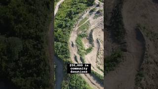
        open trail in app

        Download Trail

        Save to wishlist, Garmin & download.
        save the trail

        Find Related Routes

        Find routes and users activities that include this trail.
        find routes for this trail

        You must enter a description before submitting.