more stats
608 ft
Distance
-89 ft
Descent
00:01:35
Avg time
-89 ft
Altitude change
146 ft
Altitude min
235 ft
Altitude max
235 ft
Altitude start
146 ft
Altitude end
-14.633%
Grade
-17.187%
Grade max
-6.569%
Grade min
608 ft
Distance down
00:01:35
Avg time

The Gooch Details

  • Activities
    • Mountain Bike
    • Hike
    • Trail Running
  • Riding Area
    Delta Watershed
    Delta, British Columbia
  • Difficulty Rating
  • Voted Difficulty
    Blue (4 votes)
  • Local Popularity
    80 in Mountain Biking [+]
    • 40 in Trail Running
    • 50 in Hiking
  • Global Ranking
    #66015 in Mountain Biking [+]
    • #126028 in Trail Running
    • #113714 in Hiking
  • Trail Type
    Singletrack
  • Bike Type
    AM, XC
  • Direction
    Downhill Primary
  • Climb Difficulty
    Blue
  • Physical Rating
    Easy
  • Trail Visibility
    Always easy to follow
  • Dogs Allowed
    Yes
  • TTFs on Trail
    Jump, Gap Jump, Ladder Bridge, Log Ride

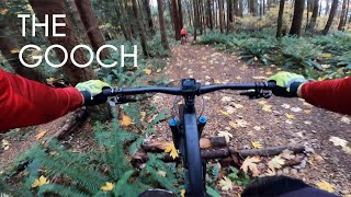
A fun trail but harder to find, there are multiple mini trails in the middle with different features on each path. There is a tiny log ride to the far left which is low and easy for beginner riders. At the very end of the trail, there is a pretty tight berm that is tons of fun to ride as you go pretty sideways and pretty fast. I wouldn't really call this trail a black but it is lots of fun to ride and one of the more fun fast trails in the watershed.

Local Trail Association

Recent Activity on Trail

Past Week
  • 0 rides
  •  
6 Months
  • 48 rides
  • 9 miles avg distance
All
  • 558 rides
  • Last: Jun 13, 2026
c1c2c3c4
January
February
March
April
May
June
July
August
September
October
November
December
Status:
on Jun 6, 2026
Ideal
Avg: 4.35 (5 votes)
Your vote: 0

view (4,240)
close
3D
Trail Conditions
  • Unknown
  • Snow Groomed
  • Snow Packed
  • Snow Covered
  • Snow Cover Partial
  • Freeze/thaw Cycle
  • Icy
  • Prevalent Mud
  • Wet
  • Variable
  • Ideal
  • Dry
  • Very Dry
Trail Flow (Ridden Direction)
Trailforks scans users ridelogs to determine the most popular direction each trail is ridden. A good flowing trail network will have most trails flowing in a single direction according to their intension.
The colour categories are based on what percentage of riders are riding a trail in its intended direction.
  • > 96%
  • > 90%
  • > 80%
  • > 70%
  • > 50%
  • < 50%
  • bi-directional trail
  • no data
Trail Last Ridden
Trailforks scans ridelogs to determine the last time a trail was ridden.
  • < 2 days
  • < 1 week
  • < 2 weeks
  • < 1 month
  • < 6 months
  • > 6 months
Trail Ridden Direction
The intended direction a trail should be ridden.
  • Downhill Only
  • Downhill Primary
  • Both Directions
  • Uphill Primary
  • Uphill Only
  • One Direction
Contribute Details
Colors indicate trail is missing specified detail.
  • Description
  • Photos
  • Description & Photos
  • Videos
Trail Popularity ?
Trailforks scans ridelogs to determine which trails are ridden the most in the last 9 months. Trails are compared with nearby trails in the same city region with a possible 25 colour shades. Think of this as a heatmap, more rides = more kinetic energy = warmer colors.
  • most popular
  • popular
  • less popular
  • not popular
ATV/ORV/OHV Filter
Max Vehicle Width
inches
US Cell Coverage
Legend
cell carrier legend

Radar Time
Activity Recordings
Trailforks uses anonymized public activity data. ?
Activity Recordings
Trailforks uses anonymized public activity data. ?
Personal Heatmap
Activity Types
all / none
Options
2
Date range month
Winter Trails
Warning A routing network for winter maps does not exist. Selecting trails using the winter trails layer has been disabled.
Missing Trails
Most Popular
Least Popular
Trails are colored based on popularity. The more popular a trail is, the more red. Less popular trails trend towards green.
Jump Magnitude Heatmap
Heatmap of where riders jump on trails. Zoom in to see individual jumps, click circles to view jump details.
BC Backroad Status

Service Road Atlas is a free to use, community-driven service for viewing and creating reports on the numerous back-country service roads around B.C. and Alberta.

map legend
Slope Aspect
Direction the slope faces
Flat N NE E SE S SW W NW
Trails Deemphasized
Trails are shown in grey.
disable
Only show trails with no bike usage.
Enable
Suggested Layers
Based on selected activity type

    Save the current map location and zoom level as your default home location whenever this page is loaded.

    Save
        Directions to the-gooch trailhead (49.116720, -122.909240)

        Photos

        16 more »
        271 |
        Mar 5, 2019 @ 8:50pm
        Mar 5, 2019
        185 |
        Mar 5, 2019 @ 8:47pm
        Mar 5, 2019
        357 |
        Mar 5, 2019 @ 8:51pm
        Mar 5, 2019
        102 |
        Oct 10, 2020 @ 3:02pm
        Oct 10, 2020

        Videos

        1 more »
        youtuber The Gooch - Delta Watershed
        0:38 | 563 | Nov 6, 2020 , Delta

        3 Reviews & Comments


        We hope you've been enjoying Trailforks!

        Create a FREE account to view trail comments and much more.

        • By canadakaTF Pro Trailforks & contributors
        • #171532 - 2,370 views

        Frequently Asked Questions About The Gooch

        Where is The Gooch located?
        The Gooch is located in Delta Watershed, Delta, British Columbia, Canada. It is part of the Delta Watershed trail network. The trailhead is located at coordinates 49.11672, -122.90924.
        How hard is The Gooch?
        The Gooch is rated as Blue difficulty. The physical rating is Easy. The average grade is 14.633%. The climb difficulty is rated Blue.
        What is the elevation gain for The Gooch?
        The trail has 89 ft of elevation descent. The elevation ranges from 146 ft to 235 ft.
        Is The Gooch a point to point trail?
        The Gooch is not a point to point trail. The direction is Downhill Primary. The trail type is singletrack.

        Hit the Trail

        Open in App

        Get this trail on your phone instantly.
        open trail in app

        Download Trail

        Save to wishlist, Garmin & download.
        save the trail

        Find Related Routes

        Find routes and users activities that include this trail.
        find routes for this trail

        You must enter a description before submitting.