more stats
3.5 miles
Distance
616 ft
Climb
-631 ft
Descent
00:53:47
Avg time
-15 ft
Altitude change
3,480 ft
Altitude min
4,021 ft
Altitude max
3,514 ft
Altitude start
3,498 ft
Altitude end
-0.084%
Grade
-19.535%
Grade max
23.693%
Grade min
1 mile
Distance climb
2 miles
Distance down
227 ft
Distance flat
00:53:47
Avg time

The Hurl Details

  • Activities
    • Mountain Bike
    • Hike
    • Trail Running
  • Riding Area
    Cottonwood Valley
    Las Vegas, Nevada
  • Difficulty Rating
  • Voted Difficulty
    Black Diamond (2 votes)
  • Local Popularity
    55 in Mountain Biking [+]
    • 70 in Trail Running
    • 55 in Hiking
  • Global Ranking
    #88789 in Mountain Biking [+]
    • #66671 in Trail Running
    • #92852 in Hiking
  • Trail Type
    Singletrack
  • Dogs Allowed
    Yes

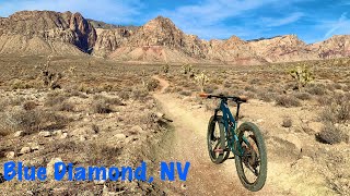
The most technically demanding trail in the BD system, the Hurl is a badge of honor and a fun trail overall. Riding it outbound from BD, you get a nice warm up, but the pitch increases quickly, and combined with loose rock, most riders dismount here and there. Once on top, the views are fantastic and the DH is twisty, rocky, and fun. If reversed, the climb is 100% rideable with practice and the DH into BD is shorter and steeper.

Trail Supporters
  • BLM
    BLM
    Land Manager
Local Trail Association

Recent Activity on Trail

Past Week
  • 1 rides
  • 8 miles average
6 Months
  • 10 rides
  • 11 miles avg distance
All
  • 82 rides
  • Last: Jun 20, 2026
c1c2c3c4
January
February
March
April
May
June
July
August
September
October
November
December
update trails status or condition

The Hurl Trail Reports

statusdatedescription
Jun 17, 2023 @ 5:45pm
Jun 17, 2023
Very loose and dry
Apr 2, 2023 @ 5:02pm
Apr 2, 2023
Accidentally rode this backwards but was still fun. Description is correct 100% rideable in reverse with a fun climb with some punchy technical...
Mar 20, 2022 @ 6:11pm
Mar 20, 2022
Dry and still steep!
Aug 7, 2021 @ 6:43am
Aug 7, 2021
Feb 12, 2021 @ 10:32am
Feb 12, 2021
more »
Status:
on Jun 17, 2023
Dry
Avg: 3.81 (21 votes)
Your vote: 0

view (415)
close
3D
Trail Conditions
  • Unknown
  • Snow Groomed
  • Snow Packed
  • Snow Covered
  • Snow Cover Partial
  • Freeze/thaw Cycle
  • Icy
  • Prevalent Mud
  • Wet
  • Variable
  • Ideal
  • Dry
  • Very Dry
Trail Flow (Ridden Direction)
Trailforks scans users ridelogs to determine the most popular direction each trail is ridden. A good flowing trail network will have most trails flowing in a single direction according to their intension.
The colour categories are based on what percentage of riders are riding a trail in its intended direction.
  • > 96%
  • > 90%
  • > 80%
  • > 70%
  • > 50%
  • < 50%
  • bi-directional trail
  • no data
Trail Last Ridden
Trailforks scans ridelogs to determine the last time a trail was ridden.
  • < 2 days
  • < 1 week
  • < 2 weeks
  • < 1 month
  • < 6 months
  • > 6 months
Trail Ridden Direction
The intended direction a trail should be ridden.
  • Downhill Only
  • Downhill Primary
  • Both Directions
  • Uphill Primary
  • Uphill Only
  • One Direction
Contribute Details
Colors indicate trail is missing specified detail.
  • Description
  • Photos
  • Description & Photos
  • Videos
Trail Popularity ?
Trailforks scans ridelogs to determine which trails are ridden the most in the last 9 months. Trails are compared with nearby trails in the same city region with a possible 25 colour shades. Think of this as a heatmap, more rides = more kinetic energy = warmer colors.
  • most popular
  • popular
  • less popular
  • not popular
ATV/ORV/OHV Filter
Max Vehicle Width
inches
US Cell Coverage
Legend
cell carrier legend

Radar Time
Activity Recordings
Trailforks uses anonymized public activity data. ?
Activity Recordings
Trailforks uses anonymized public activity data. ?
Personal Heatmap
Activity Types
all / none
Options
2
Date range month
Winter Trails
Warning A routing network for winter maps does not exist. Selecting trails using the winter trails layer has been disabled.
Missing Trails
Most Popular
Least Popular
Trails are colored based on popularity. The more popular a trail is, the more red. Less popular trails trend towards green.
Jump Magnitude Heatmap
Heatmap of where riders jump on trails. Zoom in to see individual jumps, click circles to view jump details.
BC Backroad Status

Service Road Atlas is a free to use, community-driven service for viewing and creating reports on the numerous back-country service roads around B.C. and Alberta.

map legend
Slope Aspect
Direction the slope faces
Flat N NE E SE S SW W NW
Trails Deemphasized
Trails are shown in grey.
disable
Only show trails with no bike usage.
Enable
Suggested Layers
Based on selected activity type

    Save the current map location and zoom level as your default home location whenever this page is loaded.

    Save
        Directions to the-hurl trailhead (36.039920, -115.400190)

        Photos

        38 more »
        566 |
        Jan 18, 2016 @ 9:09am
        Jan 18, 2016
        778 |
        Jan 18, 2016 @ 9:08am
        Jan 18, 2016
        40 |
        Mar 25, 2025 @ 1:03pm
        Mar 25, 2025
        42 |
        Mar 25, 2025 @ 1:03pm
        Mar 25, 2025

        Videos

        7 more »
        Blue diamond trials Nevada hear Las Vegas
        3:30 | 83 | Jun 29, 2025 , Las Vegas
        The Hurl
        10:10 | 98 | Apr 3, 2025 , Las Vegas
        The Hurl From The Top
        13:24 | 157 | Oct 4, 2024 , Las Vegas
        Blue Diamond Trails: Rocks + Cactus & LOTS...
        24:47 | 373 | Feb 24, 2023 , Las Vegas

        8 Reviews & Comments


        We hope you've been enjoying Trailforks!

        Create a FREE account to view trail comments and much more.

        Frequently Asked Questions About The Hurl

        Where is The Hurl located?
        The Hurl is located in Cottonwood Valley, Las Vegas, Nevada, United States. It is part of the Cottonwood Valley trail network. The trailhead is located at coordinates 36.03992, -115.40019.
        How hard is The Hurl?
        The Hurl is rated as Black Diamond difficulty. The average grade is 0.084%.
        What is the elevation gain for The Hurl?
        The Hurl has 616 ft of elevation gain. The trail has 631 ft of elevation descent. The elevation ranges from 3,480 ft to 4,021 ft.
        How long is The Hurl?
        The Hurl is 3.5 miles long. The trail type is singletrack.

        Hit the Trail

        Open in App

        Get this trail on your phone instantly.
        open trail in app

        Download Trail

        Save to wishlist, Garmin & download.
        save the trail

        Find Related Routes

        Find routes and users activities that include this trail.
        find routes for this trail

        You must enter a description before submitting.