more stats
6.2 miles
Distance
1,029 ft
Climb
-1,032 ft
Descent
01:04:38
Avg time
-2 ft
Altitude change
2,958 ft
Altitude min
3,183 ft
Altitude max
3,149 ft
Altitude start
3,146 ft
Altitude end
-0%
Grade
-33.8%
Grade max
35.8%
Grade min
3 miles
Distance climb
2 miles
Distance down
1 mile
Distance flat
01:04:38
Avg time

The Johnson Details

  • Activities
    • Mountain Bike
    • Winter Fat Bike
    • Hike
    • Trail Running
  • Riding Area
    Lillian Lake
    Invermere, British Columbia
  • Difficulty Rating
  • Voted Difficulty
    Blue (6 votes)
  • Local Popularity
    90 in Mountain Biking [+]
    • 90 in Trail Running
    • 80 in Hiking
  • Global Ranking
    #13766 in Mountain Biking [+]
    • #319 in Trail Running
    • #1422 in Hiking
  • Hiking SAC Scale
    T1 Hiking
  • Trail Type
    Singletrack
  • Bike Type
    AM, XC, Fat
  • Direction
    Downhill Primary
  • Climb Difficulty
    Blue
  • Physical Rating
    Moderate
  • Trail Visibility
    Always easy to follow
  • Dogs Allowed
    Yes
  • Land Owner
    RSTBC

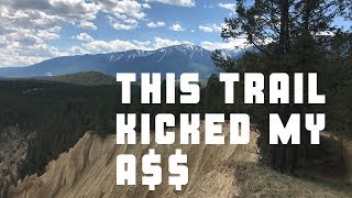
This is a classic loop with spectacular views. If you like fast and flowy singletrack, this trail is going to be up your alley. This may be an intermediate level trail, but user should be aware of numerous sections with exposure to cliff edges. This is definitely not a beginner trail and requires mandatory travel on sections of narrow exposed trail where a fall may result in serious injury.

This is a multiuse trail. Please give the right of way to hikers. Also, please stay on the trail and avoid damaging sensitive grass and habitat.

Local Trail Association
Traditionally Indigenous Territory

Recent Activity on Trail

Past Week
  • 1 rides
  • 15 miles average
6 Months
  • 22 rides
  • 10 miles avg distance
All
  • 345 rides
  • Last: Jun 20, 2026
c1c2c3c4
January
February
March
April
May
June
July
August
September
October
November
December
update trails status or condition

The Johnson Trail Reports

statusdatedescription
Apr 10, 2026 @ 4:36pm (America/Edmonton)
Apr 10, 2026
95% dry, only damp spots are closer to the road
Aug 28, 2025 @ 9:21pm
Aug 28, 2025
Great conditions. Dry overall but still so smooth, like butta!
Jul 16, 2025 @ 10:54am
Jul 16, 2025
Jun 11, 2025 @ 10:34am
Jun 11, 2025
Apr 19, 2025 @ 10:53am
Apr 19, 2025
more »
Status:
on Apr 10, 2026
Dry
Avg: 4.23 (37 votes)
Your vote: 0

view (1,986)
close
3D
Trail Conditions
  • Unknown
  • Snow Groomed
  • Snow Packed
  • Snow Covered
  • Snow Cover Partial
  • Freeze/thaw Cycle
  • Icy
  • Prevalent Mud
  • Wet
  • Variable
  • Ideal
  • Dry
  • Very Dry
Trail Flow (Ridden Direction)
Trailforks scans users ridelogs to determine the most popular direction each trail is ridden. A good flowing trail network will have most trails flowing in a single direction according to their intension.
The colour categories are based on what percentage of riders are riding a trail in its intended direction.
  • > 96%
  • > 90%
  • > 80%
  • > 70%
  • > 50%
  • < 50%
  • bi-directional trail
  • no data
Trail Last Ridden
Trailforks scans ridelogs to determine the last time a trail was ridden.
  • < 2 days
  • < 1 week
  • < 2 weeks
  • < 1 month
  • < 6 months
  • > 6 months
Trail Ridden Direction
The intended direction a trail should be ridden.
  • Downhill Only
  • Downhill Primary
  • Both Directions
  • Uphill Primary
  • Uphill Only
  • One Direction
Contribute Details
Colors indicate trail is missing specified detail.
  • Description
  • Photos
  • Description & Photos
  • Videos
Trail Popularity ?
Trailforks scans ridelogs to determine which trails are ridden the most in the last 9 months. Trails are compared with nearby trails in the same city region with a possible 25 colour shades. Think of this as a heatmap, more rides = more kinetic energy = warmer colors.
  • most popular
  • popular
  • less popular
  • not popular
ATV/ORV/OHV Filter
Max Vehicle Width
inches
US Cell Coverage
Legend
cell carrier legend

Radar Time
Activity Recordings
Trailforks uses anonymized public activity data. ?
Activity Recordings
Trailforks uses anonymized public activity data. ?
Personal Heatmap
Activity Types
all / none
Options
2
Date range month
Winter Trails
Warning A routing network for winter maps does not exist. Selecting trails using the winter trails layer has been disabled.
Missing Trails
Most Popular
Least Popular
Trails are colored based on popularity. The more popular a trail is, the more red. Less popular trails trend towards green.
Jump Magnitude Heatmap
Heatmap of where riders jump on trails. Zoom in to see individual jumps, click circles to view jump details.
BC Backroad Status

Service Road Atlas is a free to use, community-driven service for viewing and creating reports on the numerous back-country service roads around B.C. and Alberta.

map legend
Slope Aspect
Direction the slope faces
Flat N NE E SE S SW W NW
Trails Deemphasized
Trails are shown in grey.
disable
Only show trails with no bike usage.
Enable
Suggested Layers
Based on selected activity type

    Save the current map location and zoom level as your default home location whenever this page is loaded.

    Save
        Directions to the-johnson trailhead (50.503740, -116.095610)

        Photos

        82 more »
        819 |
        Jun 7, 2020 @ 7:38am
        Jun 7, 2020
        1,090 |
        Aug 19, 2018 @ 9:46pm
        Aug 19, 2018
        98 |
        Jul 8, 2024 @ 8:42am
        Jul 8, 2024
        18 |
        Jun 26, 2024 @ 4:08pm
        Jun 26, 2024

        Videos

        3 more »
        This trail kicked my A$$ -{The Johnson /...
        18:13 | 1848 | May 26, 2019 , Invermere
        Getting Lost & Finding Flow ::: Mountain...
        9:50 | 2084 | Jul 3, 2018 , Invermere
        May Long Weekend | Invermere, BC |
        1424 | Jun 1, 2017 , Invermere

        Trail Lists

        Routes with this trail

        3.3 10 miles 1,269 ft 22 Loop
        A great sampling of what Invermere has to offer. Fast & flowy, great climbs, some techy bits to keep you...

        11 Reviews & Comments


        We hope you've been enjoying Trailforks!

        Create a FREE account to view trail comments and much more.

        • By captain-sandbag & contributors
        • #17324 - 28,205 views

        Frequently Asked Questions About The Johnson

        Where is The Johnson located?
        The Johnson is located in Lillian Lake, Invermere, British Columbia, Canada. It is part of the Lillian Lake trail network. The trailhead is located at coordinates 50.50374, -116.09561.
        How hard is The Johnson?
        The Johnson is rated as Black Diamond difficulty. The physical rating is Moderate. The climb difficulty is rated Blue.
        What is the elevation gain for The Johnson?
        The Johnson has 1,029 ft of elevation gain. The trail has 1,032 ft of elevation descent. The elevation ranges from 2,958 ft to 3,183 ft.
        Is The Johnson a point to point trail?
        The Johnson is not a point to point trail. The direction is Downhill Primary. The trail type is singletrack.

        Hit the Trail

        Open in App

        Get this trail on your phone instantly.
        open trail in app

        Download Trail

        Save to wishlist, Garmin & download.
        save the trail

        Find Related Routes

        Find routes and users activities that include this trail.
        find routes for this trail

        You must enter a description before submitting.