more stats
2,910 ft
Distance
19 ft
Climb
-310 ft
Descent
00:11:10
Avg time
-292 ft
Altitude change
2,109 ft
Altitude min
2,401 ft
Altitude max
2,401 ft
Altitude start
2,110 ft
Altitude end
-10%
Grade
-37.9%
Grade max
10.4%
Grade min
322 ft
Distance climb
2,438 ft
Distance down
151 ft
Distance flat
00:11:10
Avg time

The Mantle Details

  • Activities
    • Mountain Bike
    • E-Bike
  • Riding Area
    Predator Ridge
    Vernon, British Columbia
  • Difficulty Rating
  • Voted Difficulty
    Black Diamond (6 votes)
  • Local Popularity
    80 in Mountain Biking [+]
    • 75 in E-Biking
  • Global Ranking
    #31381 in Mountain Biking [+]
    • #15639 in E-Biking
  • Trail Type
    Singletrack
  • Bike Type
    AM
  • Dogs Allowed
    Yes
  • eBike Allowed
    Yes up to Class 1
  • TTFs on Trail
    Rock Face, Rock Garden

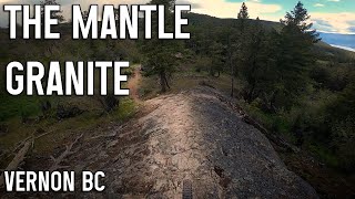
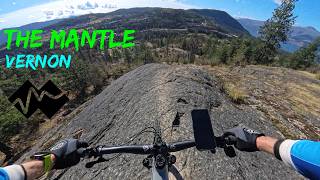
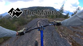
One of Predator's more technical trails. It's a tight and tricky climb to get up to the top. Once you are up there, get your fill of Moab-style rock rides and some steep slabs. Finishes with a steep and loose section that can be avoided by choosing the "easy way" off to the right.

Recent Activity on Trail

Past Week
  • 3 rides
  • 6 miles average
6 Months
  • 26 rides
  • 9 miles avg distance
All
  • 352 rides
  • Last: Jun 14, 2026
c1c2c3c4
January
February
March
April
May
June
July
August
September
October
November
December
update trails status or condition

The Mantle Trail Reports

statusdatedescription
May 27, 2026 @ 1:39pm (America/Creston)
May 27, 2026
Nov 4, 2025 @ 5:39am (America/Vancouver)
Nov 4, 2025
reporter Predator Ridge closes their mountain bike trails every fall in preparation for the freeze-thaw cycle. This is for two reasons: preservation of the...
Oct 30, 2025 @ 3:36pm (America/Vancouver)
Oct 30, 2025
May 15, 2025 @ 10:48pm
May 15, 2025
Mar 27, 2025 @ 4:09pm
Mar 27, 2025
reporter The Predator Ridge bike trails are now open for the season! Please respect all closures and detours as development continues at the resort.
more »
Status:
on May 27, 2026
Ideal
Avg: 4.39 (22 votes)
Your vote: 0

view (2,037)
close
3D
Trail Conditions
  • Unknown
  • Snow Groomed
  • Snow Packed
  • Snow Covered
  • Snow Cover Partial
  • Freeze/thaw Cycle
  • Icy
  • Prevalent Mud
  • Wet
  • Variable
  • Ideal
  • Dry
  • Very Dry
Trail Flow (Ridden Direction)
Trailforks scans users ridelogs to determine the most popular direction each trail is ridden. A good flowing trail network will have most trails flowing in a single direction according to their intension.
The colour categories are based on what percentage of riders are riding a trail in its intended direction.
  • > 96%
  • > 90%
  • > 80%
  • > 70%
  • > 50%
  • < 50%
  • bi-directional trail
  • no data
Trail Last Ridden
Trailforks scans ridelogs to determine the last time a trail was ridden.
  • < 2 days
  • < 1 week
  • < 2 weeks
  • < 1 month
  • < 6 months
  • > 6 months
Trail Ridden Direction
The intended direction a trail should be ridden.
  • Downhill Only
  • Downhill Primary
  • Both Directions
  • Uphill Primary
  • Uphill Only
  • One Direction
Contribute Details
Colors indicate trail is missing specified detail.
  • Description
  • Photos
  • Description & Photos
  • Videos
Trail Popularity ?
Trailforks scans ridelogs to determine which trails are ridden the most in the last 9 months. Trails are compared with nearby trails in the same city region with a possible 25 colour shades. Think of this as a heatmap, more rides = more kinetic energy = warmer colors.
  • most popular
  • popular
  • less popular
  • not popular
ATV/ORV/OHV Filter
Max Vehicle Width
inches
US Cell Coverage
Legend
cell carrier legend

Radar Time
Activity Recordings
Trailforks uses anonymized public activity data. ?
Activity Recordings
Trailforks uses anonymized public activity data. ?
Personal Heatmap
Activity Types
all / none
Options
2
Date range month
Winter Trails
Warning A routing network for winter maps does not exist. Selecting trails using the winter trails layer has been disabled.
Missing Trails
Most Popular
Least Popular
Trails are colored based on popularity. The more popular a trail is, the more red. Less popular trails trend towards green.
Jump Magnitude Heatmap
Heatmap of where riders jump on trails. Zoom in to see individual jumps, click circles to view jump details.
BC Backroad Status

Service Road Atlas is a free to use, community-driven service for viewing and creating reports on the numerous back-country service roads around B.C. and Alberta.

map legend
Slope Aspect
Direction the slope faces
Flat N NE E SE S SW W NW
Trails Deemphasized
Trails are shown in grey.
disable
Only show trails with no bike usage.
Enable
Suggested Layers
Based on selected activity type

    Save the current map location and zoom level as your default home location whenever this page is loaded.

    Save
        Directions to the-mantle trailhead (50.192840, -119.403700)

        Photos

        33 more »
        66 |
        Oct 6, 2023 @ 3:26pm
        Oct 6, 2023
        227 |
        Nov 4, 2021 @ 8:14am
        Nov 4, 2021
        234 |
        Nov 4, 2021 @ 8:14am
        Nov 4, 2021
        221 |
        Nov 4, 2021 @ 8:14am
        Nov 4, 2021

        Videos

        9 more »
        youtuber We Found a Hidden Gem for MTB in BC...
        15:39 | 504 | Aug 13, 2023 , Vernon
        youtuber The Mantle & Granite - Vernon Mountain...
        14:38 | 718 | Jun 18, 2022 , Vernon
        The Mantle (Predator Ridge) - Vernon
        11:06 | 35 | Mar 12, 2026 , Vernon
        The Mantle - Predator ridge
        3:40 | 114 | May 13, 2025 , Vernon

        Routes with this trail

        5.0 10 miles 1,784 ft 12
        Huge shoutout to Predator and Contour trails for building a new climb trail “the nest”. More trails...
        5.0 82 miles 9,995 ft 91
        100% self supported, no lifts, no shuttles. Let's play.
        1 mile 71 ft 1
        NOCS 2023 Predator Downhill Mantle/Predator

        11 Reviews & Comments


        We hope you've been enjoying Trailforks!

        Create a FREE account to view trail comments and much more.

        • By ThatDanTF Pro & contributors
        • #182084 - 6,283 views

        Frequently Asked Questions About The Mantle

        Where is The Mantle located?
        The Mantle is located in Predator Ridge, Vernon, British Columbia, Canada. It is part of the Predator Ridge trail network. The trailhead is located at coordinates 50.19284, -119.4037.
        How hard is The Mantle?
        The Mantle is rated as Double Black Diamond difficulty. The average grade is 10%.
        What is the elevation gain for The Mantle?
        The Mantle has 6 m of elevation gain. The trail has 95 m of elevation descent. The elevation ranges from 643 m to 732 m.
        How long is The Mantle?
        The Mantle is 887.0 m long. The trail type is singletrack.

        Hit the Trail

        Open in App

        Get this trail on your phone instantly.
        open trail in app

        Download Trail

        Save to wishlist, Garmin & download.
        save the trail

        Find Related Routes

        Find routes and users activities that include this trail.
        find routes for this trail

        You must enter a description before submitting.