more stats
3,783 ft
Distance
-845 ft
Descent
00:10:47
Avg time
-845 ft
Altitude change
614 ft
Altitude min
1,460 ft
Altitude max
1,460 ft
Altitude start
614 ft
Altitude end
-22.3%
Grade
-52.4%
Grade max
-0.9%
Grade min
3,724 ft
Distance down
23 ft
Distance flat
00:10:47
Avg time

The Schist Details

  • Activities
    • Mountain Bike
  • Riding Area
    Thunder Mountain Bike Park
    Charlemont, Massachusetts
  • Difficulty Rating
  • Local Popularity
    45 in Mountain Biking
  • Global Ranking
    #7938 in Mountain Biking
  • Trail Type
    Singletrack
  • Bike Type
    DH
  • Direction
    Downhill Only
    Popular Direction Shown
  • Physical Rating
    Moderate
  • eBike Allowed
  • TTFs on Trail
    Berm, Jump, Rock Garden, Other
  • Land Owner
    Jon Schaefer

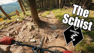
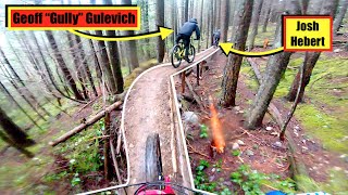
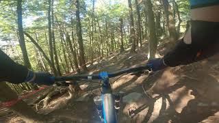
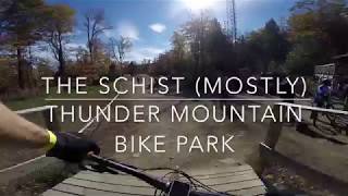
Trail starts of fast with some fun woodwork, then takes you through the trees for some technical steep sections. Mostly straight down through the forest. If you like old school tech, you'll love this.

In the winter, 100% of this MTB trail can be skied w/ sufficient snow coverage. It represents a fun tree run that starts in the Tomahawk Glade and parallels the Triple Chair. Single diamond difficulty, in the winter.

Bike Park

Local Trail Association
Traditionally Indigenous Territory

Recent Activity on Trail

Past Week
  • 3 rides
  • 22 miles average
6 Months
  • 13 rides
  • 27 miles avg distance
All
  • 249 rides
  • Last: Jun 21, 2026
c1c2c3c4
January
February
March
April
May
June
July
August
September
October
November
December
Status:
on Aug 8, 2025
Dry
Avg: 4.47 (11 votes)
Your vote: 0

view (2,346)
close
3D
Trail Conditions
  • Unknown
  • Snow Groomed
  • Snow Packed
  • Snow Covered
  • Snow Cover Partial
  • Freeze/thaw Cycle
  • Icy
  • Prevalent Mud
  • Wet
  • Variable
  • Ideal
  • Dry
  • Very Dry
Trail Flow (Ridden Direction)
Trailforks scans users ridelogs to determine the most popular direction each trail is ridden. A good flowing trail network will have most trails flowing in a single direction according to their intension.
The colour categories are based on what percentage of riders are riding a trail in its intended direction.
  • > 96%
  • > 90%
  • > 80%
  • > 70%
  • > 50%
  • < 50%
  • bi-directional trail
  • no data
Trail Last Ridden
Trailforks scans ridelogs to determine the last time a trail was ridden.
  • < 2 days
  • < 1 week
  • < 2 weeks
  • < 1 month
  • < 6 months
  • > 6 months
Trail Ridden Direction
The intended direction a trail should be ridden.
  • Downhill Only
  • Downhill Primary
  • Both Directions
  • Uphill Primary
  • Uphill Only
  • One Direction
Contribute Details
Colors indicate trail is missing specified detail.
  • Description
  • Photos
  • Description & Photos
  • Videos
Trail Popularity ?
Trailforks scans ridelogs to determine which trails are ridden the most in the last 9 months. Trails are compared with nearby trails in the same city region with a possible 25 colour shades. Think of this as a heatmap, more rides = more kinetic energy = warmer colors.
  • most popular
  • popular
  • less popular
  • not popular
ATV/ORV/OHV Filter
Max Vehicle Width
inches
US Cell Coverage
Legend
cell carrier legend

Radar Time
Activity Recordings
Trailforks uses anonymized public activity data. ?
Activity Recordings
Trailforks uses anonymized public activity data. ?
Personal Heatmap
Activity Types
all / none
Options
2
Date range month
Winter Trails
Warning A routing network for winter maps does not exist. Selecting trails using the winter trails layer has been disabled.
Missing Trails
Most Popular
Least Popular
Trails are colored based on popularity. The more popular a trail is, the more red. Less popular trails trend towards green.
Jump Magnitude Heatmap
Heatmap of where riders jump on trails. Zoom in to see individual jumps, click circles to view jump details.
BC Backroad Status

Service Road Atlas is a free to use, community-driven service for viewing and creating reports on the numerous back-country service roads around B.C. and Alberta.

map legend
Slope Aspect
Direction the slope faces
Flat N NE E SE S SW W NW
Trails Deemphasized
Trails are shown in grey.
disable
Only show trails with no bike usage.
Enable
Suggested Layers
Based on selected activity type

    Save the current map location and zoom level as your default home location whenever this page is loaded.

    Save
        Directions to the-schist trailhead (42.615100, -72.869490)

        Photos

        20 more »
        99 |
        Dec 25, 2024 @ 5:50pm
        Dec 25, 2024
        85 |
        Dec 25, 2024 @ 5:50pm
        Dec 25, 2024
        101 |
        Sep 22, 2023 @ 10:48am
        Sep 22, 2023
        98 |
        Nov 28, 2021 @ 1:16pm
        Nov 28, 2021

        Videos

        13 more »
        youtuber Getting in Over Our Heads on This Double Black...
        7:49 | 355 | Dec 12, 2022 , Charlemont
        youtuber Most INSANE Moments of 2022! (Pt. 3) - 'Land...
        11:01 | 94 | Mar 9, 2023 , Charlemont
        Thunder Mountain - The Schist, September 6th, 2020
        6:03 | 244 | Jul 11, 2022 , Charlemont
        WRONG TRAIL! The Schist   Thunder Mountain
        4:51 | 466 | Oct 22, 2018 , Charlemont

        Trail Lists

        1 Review & Comments


        We hope you've been enjoying Trailforks!

        Create a FREE account to view trail comments and much more.

        • By mtbzineTF Pro & contributors
        • #61658 - 3,304 views

        Frequently Asked Questions About The Schist

        Where is The Schist located?
        The Schist is located in Thunder Mountain Bike Park, Charlemont, Massachusetts, United States. It is part of the Thunder Mountain Bike Park trail network. The trailhead is located at coordinates 42.6151, -72.86949.
        How hard is The Schist?
        The Schist is rated as Double Black Diamond difficulty. The physical rating is Moderate. The average grade is 22.3%.
        What is the elevation gain for The Schist?
        The trail has 845 ft of elevation descent. The elevation ranges from 614 ft to 1,460 ft.
        Is The Schist a point to point trail?
        Yes, The Schist is a point to point trail. The direction is Downhill Only. The trail type is singletrack.

        Hit the Trail

        Open in App

        Get this trail on your phone instantly.
        open trail in app

        Download Trail

        Save to wishlist, Garmin & download.
        save the trail

        Find Related Routes

        Find routes and users activities that include this trail.
        find routes for this trail

        You must enter a description before submitting.