more stats
5,233 ft
Distance
159 ft
Climb
-41 ft
Descent
00:09:24
Avg time
118 ft
Altitude change
1,281 ft
Altitude min
1,418 ft
Altitude max
1,285 ft
Altitude start
1,404 ft
Altitude end
2.3%
Grade
-6.9%
Grade max
14.4%
Grade min
3,012 ft
Distance climb
1,237 ft
Distance down
984 ft
Distance flat
00:09:24
Avg time

The Tickler Details

  • Activities
    • Mountain Bike
    • E-Bike
  • Riding Area
  • Difficulty Rating
  • Local Popularity
    90 in Mountain Biking [+]
    • 95 in E-Biking
  • Global Ranking
    #1251 in Mountain Biking [+]
    • #2828 in E-Biking
  • Trail Type
    Singletrack
  • Direction
    Downhill Only
    Popular Direction Shown
  • Dogs Allowed
    Yes
  • eBike Allowed
    Yes up to Class 1

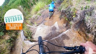
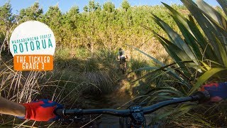
The Tickler has a fast section at the start, dropping down to the creek. This section was revised in September 2012, to bypass the original entrance section. This was technical and suffered from rain and braking ruts making it harder than the grade 3 designation of the trail.

Shortly after the creek crossing there is a short but tricky pinch climb to a clearing with a few of the remaining Californian Redwoods from the orignal stand of forest. Take a moment here and keep your eyes and ears open. One of the NZ native falcons released in 2013 has been making itself at home in this area.

The next stage follows the profile and style of the original trail which was lost in the 2011 harvesting activity. It is a gradual climb from the stand of Redwoods – no steep sections, just a gradual climb that winds its way up.
Normally handles wet weather well. The occasional hard frost in the middle of winter can make it slippery as the frozen surface softens during the day.

source: Ride Rotorua
Access Info

Starting from the skid site at the end of Spruce Rd (you get there via Katore Jumps or another favorite, Paddy's Run (formerly called A Trail).

Local Trail Association

Recent Activity on Trail

Past Week
  • 10 rides
  • 17 miles average
6 Months
  • 329 rides
  • 19 miles avg distance
All
  • 2,738 rides
  • Last: Jun 22, 2026
c1c2c3c4
January
February
March
April
May
June
July
August
September
October
November
December
update trails status or condition

The Tickler Trail Reports

statusdatedescription
Jun 7, 2026 @ 2:46pm (Pacific/Auckland)
Jun 6, 2026
reporter Someone else did the hard yards but a bit of a tidy up done, tree down in previous report has been cleared
Jun 4, 2026 @ 4:42pm (Pacific/Auckland)
Jun 3, 2026
Treeact across trail, 150mm thick , can't get around.
May 14, 2026 @ 8:30am (Pacific/Auckland)
May 13, 2026
Apr 11, 2026 @ 7:13am (Pacific/Auckland)
Apr 10, 2026
Mar 14, 2026 @ 9:27am (Pacific/Auckland)
Mar 13, 2026
more »
Status:
on Jun 7, 2026
Wet
Avg: 3.23 (24 votes)
Your vote: 0

view (16,968)
close
3D
Trail Conditions
  • Unknown
  • Snow Groomed
  • Snow Packed
  • Snow Covered
  • Snow Cover Partial
  • Freeze/thaw Cycle
  • Icy
  • Prevalent Mud
  • Wet
  • Variable
  • Ideal
  • Dry
  • Very Dry
Trail Flow (Ridden Direction)
Trailforks scans users ridelogs to determine the most popular direction each trail is ridden. A good flowing trail network will have most trails flowing in a single direction according to their intension.
The colour categories are based on what percentage of riders are riding a trail in its intended direction.
  • > 96%
  • > 90%
  • > 80%
  • > 70%
  • > 50%
  • < 50%
  • bi-directional trail
  • no data
Trail Last Ridden
Trailforks scans ridelogs to determine the last time a trail was ridden.
  • < 2 days
  • < 1 week
  • < 2 weeks
  • < 1 month
  • < 6 months
  • > 6 months
Trail Ridden Direction
The intended direction a trail should be ridden.
  • Downhill Only
  • Downhill Primary
  • Both Directions
  • Uphill Primary
  • Uphill Only
  • One Direction
Contribute Details
Colors indicate trail is missing specified detail.
  • Description
  • Photos
  • Description & Photos
  • Videos
Trail Popularity ?
Trailforks scans ridelogs to determine which trails are ridden the most in the last 9 months. Trails are compared with nearby trails in the same city region with a possible 25 colour shades. Think of this as a heatmap, more rides = more kinetic energy = warmer colors.
  • most popular
  • popular
  • less popular
  • not popular
ATV/ORV/OHV Filter
Max Vehicle Width
inches
US Cell Coverage
Legend
cell carrier legend

Radar Time
Activity Recordings
Trailforks uses anonymized public activity data. ?
Activity Recordings
Trailforks uses anonymized public activity data. ?
Personal Heatmap
Activity Types
all / none
Options
2
Date range month
Winter Trails
Warning A routing network for winter maps does not exist. Selecting trails using the winter trails layer has been disabled.
Missing Trails
Most Popular
Least Popular
Trails are colored based on popularity. The more popular a trail is, the more red. Less popular trails trend towards green.
Jump Magnitude Heatmap
Heatmap of where riders jump on trails. Zoom in to see individual jumps, click circles to view jump details.
BC Backroad Status

Service Road Atlas is a free to use, community-driven service for viewing and creating reports on the numerous back-country service roads around B.C. and Alberta.

map legend
Slope Aspect
Direction the slope faces
Flat N NE E SE S SW W NW
Trails Deemphasized
Trails are shown in grey.
disable
Only show trails with no bike usage.
Enable
Suggested Layers
Based on selected activity type

    Save the current map location and zoom level as your default home location whenever this page is loaded.

    Save
        Directions to the-tickler trailhead (-38.168310, 176.284630)

        Photos

        37 more »
        73 |
        Feb 18, 2019 @ 10:46am
        Feb 18, 2019
        23 |
        Dec 27, 2024 @ 1:14pm
        Dec 27, 2024
        31 |
        May 10, 2023 @ 4:16pm
        May 10, 2023
        29 |
        May 22, 2022 @ 2:37pm
        May 22, 2022

        Videos

        3 more »
        Tickler - Redwoods 24.2.24
        7:21 | 275 | Feb 24, 2024 , Rotorua
        The Tickler, Rotorua - The ORIGINAL line at...
        0:14 | 825 | Oct 30, 2019 , Rotorua
        Tickler, Rotorua - Not your normal tickle
        2:07 | 685 | Aug 22, 2019 , Rotorua

        Trail Lists

        Routes with this trail

        4.0 18 miles 3,050 ft 42 Loop
        A good intermediate - upper intermediate loop. A couple of good solid climbs but you will always be...
        4.0 17 miles 2,894 ft 29 Loop
        Not sure what trails to ride in Whakarewarea Forest. Well these are a solid set of trails that offer...
        5.0 20 miles 3,052 ft 19 Point to Point Race
        Embark on an unforgettable journey through New Zealand’s most iconic mountain biking landscapes....

        1 Review & Comments


        We hope you've been enjoying Trailforks!

        Create a FREE account to view trail comments and much more.

        Frequently Asked Questions About The Tickler

        Where is The Tickler located?
        The Tickler is located in Whakarewarewa Forest, Rotorua, New Zealand. It is part of the Whakarewarewa Forest trail network. The trailhead is located at coordinates -38.16831, 176.28463.
        How hard is The Tickler?
        The Tickler is rated as Blue difficulty. The average grade is 2.3%.
        What is the elevation gain for The Tickler?
        The Tickler has 159 ft of elevation gain. The trail has 41 ft of elevation descent. The elevation ranges from 1,281 ft to 1,418 ft.
        Is The Tickler a point to point trail?
        Yes, The Tickler is a point to point trail. The direction is Downhill Only. The trail type is singletrack.

        Hit the Trail

        Open in App

        Get this trail on your phone instantly.
        open trail in app

        Download Trail

        Save to wishlist, Garmin & download.
        save the trail

        Find Related Routes

        Find routes and users activities that include this trail.
        find routes for this trail

        You must enter a description before submitting.