more stats
3,488 ft
Distance
47 ft
Climb
-14 ft
Descent
00:04:47
Avg time
8 ft
Altitude change
926 ft
Altitude min
973 ft
Altitude max
926 ft
Altitude start
935 ft
Altitude end
0.2%
Grade
-8.8%
Grade max
11%
Grade min
522 ft
Distance climb
476 ft
Distance down
2,477 ft
Distance flat
00:04:47
Avg time

Thing 2 Details

  • Activities
    • Mountain Bike
    • E-Bike
    • Winter Fat Bike
    • Hike
    • Trail Running
    • Snowshoe
  • Riding Area
    Boyne Forest Trails
    Boyne City, Michigan
  • Difficulty Rating
  • Local Popularity
    80 in Mountain Biking [+]
    • 65 in E-Biking
    • 5 in Trail Running
    • 70 in Hiking
  • Global Ranking
    #120292 in Mountain Biking [+]
    • #220679 in Trail Running
    • #86149 in Hiking
  • Trail Type
    Singletrack
  • Snow Grooming
    Backcountry
  • Bike Type
    AM, XC, Fat
  • Direction
    Both Directions[+]
    Popular In Reverse
    • Both Directions for Snowshoeing
  • Dogs Allowed
    Yes
  • eBike Allowed
    Yes up to Class 1
  • Lighting
    No

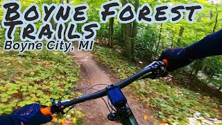
Thing 2 built by TOMMBA to connect east BFT section of Hog Wild and Loop 2 to Double Dog loop and new main parking lot on Old Horton Bay Rd. This is a bi-directional trail to allow users to connect to both sides of the trail system.

Local Trail Association
Traditionally Indigenous Territory

Recent Activity on Trail

Past Week
  • 4 rides
  • 10 miles average
6 Months
  • 46 rides
  • 10 miles avg distance
All
  • 552 rides
  • Last: Jun 16, 2026
c1c2c3c4
January
February
March
April
May
June
July
August
September
October
November
December
update trails status or condition

Thing 2 Trail Reports

statusdatedescription
Feb 6, 2026 @ 1:59pm (America/Detroit)
Feb 6, 2026
reporter Trail last groomed - 2-6-2026. Conditions are still a little soft. Keep tire pressures low (2-5 psi).
Jan 28, 2026 @ 11:01pm (America/Detroit)
Jan 28, 2026
reporter TRail last groomed - 1-28-26. Conditions are soft. Keep pressures low (2-5 psi).
Jan 20, 2026 @ 9:22pm (America/Detroit)
Jan 20, 2026
reporter Fresh groom and fresh snow. The groomers are making multiple grooming passes and the snow is still coming down. Expect groomed soft conditions. ...
Jan 10, 2026 @ 11:33am (America/Detroit)
Jan 10, 2026
reporter Trail is frozen hard. Snow expected today (1/10). Grooming to follow.
Jan 8, 2026 @ 1:24pm (America/Detroit)
Jan 8, 2026
reporter Closed due to soft conditions - Hope to reopen January 10 or 11.
more »
Status:
on Feb 6, 2026
Snow Groomed
Avg: 3.99 (2 votes)
Your vote: 0

view (2,801)
close
3D
Trail Conditions
  • Unknown
  • Snow Groomed
  • Snow Packed
  • Snow Covered
  • Snow Cover Partial
  • Freeze/thaw Cycle
  • Icy
  • Prevalent Mud
  • Wet
  • Variable
  • Ideal
  • Dry
  • Very Dry
Trail Flow (Ridden Direction)
Trailforks scans users ridelogs to determine the most popular direction each trail is ridden. A good flowing trail network will have most trails flowing in a single direction according to their intension.
The colour categories are based on what percentage of riders are riding a trail in its intended direction.
  • > 96%
  • > 90%
  • > 80%
  • > 70%
  • > 50%
  • < 50%
  • bi-directional trail
  • no data
Trail Last Ridden
Trailforks scans ridelogs to determine the last time a trail was ridden.
  • < 2 days
  • < 1 week
  • < 2 weeks
  • < 1 month
  • < 6 months
  • > 6 months
Trail Ridden Direction
The intended direction a trail should be ridden.
  • Downhill Only
  • Downhill Primary
  • Both Directions
  • Uphill Primary
  • Uphill Only
  • One Direction
Contribute Details
Colors indicate trail is missing specified detail.
  • Description
  • Photos
  • Description & Photos
  • Videos
Trail Popularity ?
Trailforks scans ridelogs to determine which trails are ridden the most in the last 9 months. Trails are compared with nearby trails in the same city region with a possible 25 colour shades. Think of this as a heatmap, more rides = more kinetic energy = warmer colors.
  • most popular
  • popular
  • less popular
  • not popular
ATV/ORV/OHV Filter
Max Vehicle Width
inches
US Cell Coverage
Legend
cell carrier legend

Radar Time
Activity Recordings
Trailforks uses anonymized public activity data. ?
Activity Recordings
Trailforks uses anonymized public activity data. ?
Personal Heatmap
Activity Types
all / none
Options
2
Date range month
Winter Trails
Warning A routing network for winter maps does not exist. Selecting trails using the winter trails layer has been disabled.
Missing Trails
Most Popular
Least Popular
Trails are colored based on popularity. The more popular a trail is, the more red. Less popular trails trend towards green.
Jump Magnitude Heatmap
Heatmap of where riders jump on trails. Zoom in to see individual jumps, click circles to view jump details.
BC Backroad Status

Service Road Atlas is a free to use, community-driven service for viewing and creating reports on the numerous back-country service roads around B.C. and Alberta.

map legend
Slope Aspect
Direction the slope faces
Flat N NE E SE S SW W NW
Trails Deemphasized
Trails are shown in grey.
disable
Only show trails with no bike usage.
Enable
Suggested Layers
Based on selected activity type

    Save the current map location and zoom level as your default home location whenever this page is loaded.

    Save
        Directions to thing-2-407254 trailhead (45.259680, -85.018830)

        Photos

        No photos have been added for Thing 2 yet, add a photo.

        Videos

        1 more »
        Tour of the Boyne School Forest Mtb trails,...
        6:24 | 277 | Feb 22, 2022 , Boyne City

        Reviews / Comments

        No reviews yet, be the first to write a review or ask a question.
        Use trail reports to comment on trail conditions.


        We hope you've been enjoying Trailforks!

        Create a FREE account to view trail comments and much more.

        • By CJBensonTF Pro TOMMBA & contributors
        • #407254 - 1,009 views

        Frequently Asked Questions About Thing 2

        Where is Thing 2 located?
        Thing 2 is located in Boyne Forest Trails, Boyne City, Michigan, United States. It is part of the Boyne Forest Trails trail network. The trailhead is located at coordinates 45.25968, -85.01883.
        How hard is Thing 2?
        Thing 2 is rated as Green difficulty. The average grade is 0.2%.
        What is the elevation gain for Thing 2?
        Thing 2 has 47 ft of elevation gain. The trail has 14 ft of elevation descent. The elevation ranges from 926 ft to 973 ft.
        Is Thing 2 a point to point trail?
        Thing 2 is not a point to point trail. The direction is Both Directions. The trail type is singletrack.

        Hit the Trail

        Open in App

        Get this trail on your phone instantly.
        open trail in app

        Download Trail

        Save to wishlist, Garmin & download.
        save the trail

        Find Related Routes

        Find routes and users activities that include this trail.
        find routes for this trail

        You must enter a description before submitting.