more stats
1,398 ft
Distance
21 ft
Climb
-85 ft
Descent
00:05:53
Avg time
-67 ft
Altitude change
2,669 ft
Altitude min
2,736 ft
Altitude max
2,736 ft
Altitude start
2,671 ft
Altitude end
-4.8%
Grade
-29.6%
Grade max
13%
Grade min
240 ft
Distance climb
699 ft
Distance down
459 ft
Distance flat
00:05:53
Avg time

Three Birds Details

  • Activities
    • Mountain Bike
    • E-Bike
    • Hike
    • Trail Running
  • Riding Area
    Westside - Sproatt
    Whistler, British Columbia
  • Difficulty Rating
  • Voted Difficulty
    Black Diamond (1 vote)
  • Local Popularity
    80 in Mountain Biking [+]
    • 70 in E-Biking
    • 40 in Trail Running
    • 35 in Hiking
  • Global Ranking
    #54228 in Mountain Biking [+]
    • #56830 in E-Biking
    • #121109 in Trail Running
    • #117674 in Hiking
  • Hiking SAC Scale
    T2 Mountain Hiking
  • Trail Type
    Singletrack
  • Bike Type
    AM, XC
  • Direction
    Downhill Primary
    Popular Direction Shown
  • Climb Difficulty
    Black Diamond
  • Physical Rating
    Moderate
  • Trail Visibility
    Always easy to follow
  • Dogs Allowed
    Yes
  • eBike Allowed
    Yes up to Class 1
  • TTFs on Trail
    Rock Face

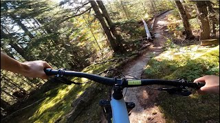
A short trail that can be added on to Flank descents such as High Society and Working Class, and links quite nicely with lower trails such as AC DC and Middle Danimal. Can also be accessed from Lower Sproat. The trail contains several short fun rock rolls and a couple punchy but climbable ups.

Stay left at the split 20m in, as going right is for Yoda's.

Access Info

For those climbing Lower Sproat - on the right after finishing A La Mode.
For those finishing High Society or Working Class - go left along the High Society/Industrial Connector back to Sproat, then turn right on Lower Sproat for approximately 30m.

Local Trail Association

Recent Activity on Trail

Past Week
  • 5 rides
  • 12 miles average
6 Months
  • 76 rides
  • 12 miles avg distance
All
  • 999 rides
  • Last: Jun 22, 2026
c1c2c3c4
January
February
March
April
May
June
July
August
September
October
November
December
update trails status or condition

Three Birds Trail Reports

statusdatedescription
Jun 16, 2026 @ 2:37pm (America/Vancouver)
Jun 16, 2026
May 30, 2026 @ 10:13am (America/Vancouver)
May 30, 2026
Apr 4, 2026 @ 7:59pm (America/Vancouver)
Apr 4, 2026
Came in with hand saw just a couple hours after you Timmo and cleared out the tree. No more decapitation. Just the leftover snow to contend with now.
Apr 4, 2026 @ 4:00pm (America/Vancouver)
Apr 4, 2026
Small tree down capable of decapitation. Easy to walk under. The snow patch in the depression at the bottom of the big rockroll is still there,...
Mar 8, 2026 @ 3:20pm (America/Vancouver)
Mar 8, 2026
Okay, okay I was too optimistic there's big patches of snow in the low sections where you're definitely hiking a bike
more »
Status:
on Jun 16, 2026
Ideal
Avg: 3.69 (20 votes)
Your vote: 0

view (5,673)
close
3D
Trail Conditions
  • Unknown
  • Snow Groomed
  • Snow Packed
  • Snow Covered
  • Snow Cover Partial
  • Freeze/thaw Cycle
  • Icy
  • Prevalent Mud
  • Wet
  • Variable
  • Ideal
  • Dry
  • Very Dry
Trail Flow (Ridden Direction)
Trailforks scans users ridelogs to determine the most popular direction each trail is ridden. A good flowing trail network will have most trails flowing in a single direction according to their intension.
The colour categories are based on what percentage of riders are riding a trail in its intended direction.
  • > 96%
  • > 90%
  • > 80%
  • > 70%
  • > 50%
  • < 50%
  • bi-directional trail
  • no data
Trail Last Ridden
Trailforks scans ridelogs to determine the last time a trail was ridden.
  • < 2 days
  • < 1 week
  • < 2 weeks
  • < 1 month
  • < 6 months
  • > 6 months
Trail Ridden Direction
The intended direction a trail should be ridden.
  • Downhill Only
  • Downhill Primary
  • Both Directions
  • Uphill Primary
  • Uphill Only
  • One Direction
Contribute Details
Colors indicate trail is missing specified detail.
  • Description
  • Photos
  • Description & Photos
  • Videos
Trail Popularity ?
Trailforks scans ridelogs to determine which trails are ridden the most in the last 9 months. Trails are compared with nearby trails in the same city region with a possible 25 colour shades. Think of this as a heatmap, more rides = more kinetic energy = warmer colors.
  • most popular
  • popular
  • less popular
  • not popular
ATV/ORV/OHV Filter
Max Vehicle Width
inches
US Cell Coverage
Legend
cell carrier legend

Radar Time
Activity Recordings
Trailforks uses anonymized public activity data. ?
Activity Recordings
Trailforks uses anonymized public activity data. ?
Personal Heatmap
Activity Types
all / none
Options
2
Date range month
Winter Trails
Warning A routing network for winter maps does not exist. Selecting trails using the winter trails layer has been disabled.
Missing Trails
Most Popular
Least Popular
Trails are colored based on popularity. The more popular a trail is, the more red. Less popular trails trend towards green.
Jump Magnitude Heatmap
Heatmap of where riders jump on trails. Zoom in to see individual jumps, click circles to view jump details.
BC Backroad Status

Service Road Atlas is a free to use, community-driven service for viewing and creating reports on the numerous back-country service roads around B.C. and Alberta.

map legend
Slope Aspect
Direction the slope faces
Flat N NE E SE S SW W NW
Trails Deemphasized
Trails are shown in grey.
disable
Only show trails with no bike usage.
Enable
Suggested Layers
Based on selected activity type

    Save the current map location and zoom level as your default home location whenever this page is loaded.

    Save
        Directions to three-birds trailhead (50.100730, -123.008760)

        Photos

        16 more »
        2 |
        Jun 15, 2026 @ 5:11pm
        Jun 15, 2026
        4 |
        Jun 15, 2026 @ 3:57pm
        Jun 15, 2026
        6 |
        Jun 15, 2026 @ 3:57pm
        Jun 15, 2026
        1 |
        Jun 15, 2026 @ 3:56pm
        Jun 15, 2026

        Videos

        7 more »
        youtuber THREE BIRDS | Black trail | Whistler
        2:24 | 188 | Nov 27, 2023 , Whistler
        youtuber Why Is Deciding What Trail So Hard Sometimes?
        6:30 | 18 | May 25, 2026 , Whistler
        youtuber The Best Gnarly Whistler Westside Slab Trails...
        8:53 | 90 | Jul 28, 2025 , Whistler
        youtuber Bleeding Out Of What Hole ?!?
        9:41 | 166 | Apr 21, 2024 , Whistler

        Trail Lists

        Routes with this trail

        4.2 13 miles 1,896 ft 41 Loop
        A Sample of Whistler's Westside is an advanced technical trail featuring several rockfaces, difficult...
        3.0 1 mile 19 ft 5
        WORCA Virtual Thriller Monday, August 12- Saturday, August 17 Collect your badge to earn your Apres deal...
        2.0 6 miles 2,089 ft 6
        Stage 1: "Hardly Working" This is the most XC feeling stage of the race and a nice way to start the day!...

        Trail Products

        2 Reviews & Comments


        We hope you've been enjoying Trailforks!

        Create a FREE account to view trail comments and much more.

        Frequently Asked Questions About Three Birds

        Where is Three Birds located?
        Three Birds is located in Westside - Sproatt, Whistler, British Columbia, Canada. It is part of the Westside - Sproatt trail network. The trailhead is located at coordinates 50.10073, -123.00876.
        How hard is Three Birds?
        Three Birds is rated as Black Diamond difficulty. The physical rating is Moderate. The average grade is 4.8%. The climb difficulty is rated Black Diamond.
        What is the elevation gain for Three Birds?
        Three Birds has 6 m of elevation gain. The trail has 26 m of elevation descent. The elevation ranges from 814 m to 834 m.
        Is Three Birds a point to point trail?
        Three Birds is not a point to point trail. The direction is Downhill Primary. The trail type is singletrack.

        Hit the Trail

        Open in App

        Get this trail on your phone instantly.
        open trail in app

        Download Trail

        Save to wishlist, Garmin & download.
        save the trail

        Find Related Routes

        Find routes and users activities that include this trail.
        find routes for this trail

        You must enter a description before submitting.