more stats
3.0 miles
Distance
837 ft
Climb
-298 ft
Descent
00:34:41
Avg time
541 ft
Altitude change
5,708 ft
Altitude min
6,267 ft
Altitude max
5,726 ft
Altitude start
6,266 ft
Altitude end
3.5%
Grade
-31.7%
Grade max
31.9%
Grade min
2 miles
Distance climb
3,658 ft
Distance down
1,135 ft
Distance flat
00:34:41
Avg time

Three Falls Details

  • Activities
    • Mountain Bike
    • E-Bike
    • Hike
    • Trail Running
  • Riding Area
    Lambert Park
    Alpine, Utah
  • Difficulty Rating
  • Local Popularity
    85 in Mountain Biking [+]
    • 95 in E-Biking
    • 95 in Trail Running
    • 100 in Hiking
  • Global Ranking
    #31657 in Mountain Biking [+]
    • #2351 in E-Biking
    • #494 in Trail Running
    • #1381 in Hiking
  • Trail Type
    Singletrack
  • Direction
    Both Directions
  • Climb Difficulty
    Blue
  • Physical Rating
    Moderate
  • Dogs Allowed
    Yes
  • eBike Allowed
    Yes up to Class 1
  • Year Opened
    2017

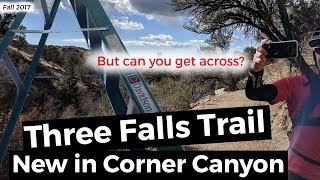
New Trail in Corner Canyon, may not be officially open yet, and terminates near the sliding rock because of a missing bridge. Hopefully this trail will punch through to Alpine soon. Update: The bridge is in place and open as of 4/10/2018

Trail Supporters
Traditionally Indigenous Territory

Recent Activity on Trail

Past Week
  • 5 rides
  • 24 miles average
6 Months
  • 58 rides
  • 21 miles avg distance
All
  • 581 rides
  • Last: Jun 19, 2026
c1c2c3c4
January
February
March
April
May
June
July
August
September
October
November
December
update trails status or condition

Three Falls Trail Reports

statusdatedescription
May 25, 2026 @ 4:19pm (America/Denver)
May 25, 2026
Very dry and dusty. Watch for hikers around the waterfalls, especially as you're coming down some of the steeper spots.
May 11, 2026 @ 8:01pm (America/Denver)
May 11, 2026
Back to its normal dry, gravelly self
Apr 4, 2026 @ 8:19pm (America/Denver)
Apr 4, 2026
Top mile still snotty
Mar 16, 2026 @ 10:37pm (America/Denver)
Mar 16, 2026
In great shape except for a muddy mess about a mile before the top. Please don’t ride that spot but otherwise it’s prime.
Jun 17, 2025 @ 5:32pm
Jun 17, 2025
more »
Status:
on May 25, 2026
Very Dry
Avg: 4.38 (23 votes)
Your vote: 0

view (6,171)
close
3D
Trail Conditions
  • Unknown
  • Snow Groomed
  • Snow Packed
  • Snow Covered
  • Snow Cover Partial
  • Freeze/thaw Cycle
  • Icy
  • Prevalent Mud
  • Wet
  • Variable
  • Ideal
  • Dry
  • Very Dry
Trail Flow (Ridden Direction)
Trailforks scans users ridelogs to determine the most popular direction each trail is ridden. A good flowing trail network will have most trails flowing in a single direction according to their intension.
The colour categories are based on what percentage of riders are riding a trail in its intended direction.
  • > 96%
  • > 90%
  • > 80%
  • > 70%
  • > 50%
  • < 50%
  • bi-directional trail
  • no data
Trail Last Ridden
Trailforks scans ridelogs to determine the last time a trail was ridden.
  • < 2 days
  • < 1 week
  • < 2 weeks
  • < 1 month
  • < 6 months
  • > 6 months
Trail Ridden Direction
The intended direction a trail should be ridden.
  • Downhill Only
  • Downhill Primary
  • Both Directions
  • Uphill Primary
  • Uphill Only
  • One Direction
Contribute Details
Colors indicate trail is missing specified detail.
  • Description
  • Photos
  • Description & Photos
  • Videos
Trail Popularity ?
Trailforks scans ridelogs to determine which trails are ridden the most in the last 9 months. Trails are compared with nearby trails in the same city region with a possible 25 colour shades. Think of this as a heatmap, more rides = more kinetic energy = warmer colors.
  • most popular
  • popular
  • less popular
  • not popular
ATV/ORV/OHV Filter
Max Vehicle Width
inches
US Cell Coverage
Legend
cell carrier legend

Radar Time
Activity Recordings
Trailforks uses anonymized public activity data. ?
Activity Recordings
Trailforks uses anonymized public activity data. ?
Personal Heatmap
Activity Types
all / none
Options
2
Date range month
Winter Trails
Warning A routing network for winter maps does not exist. Selecting trails using the winter trails layer has been disabled.
Missing Trails
Most Popular
Least Popular
Trails are colored based on popularity. The more popular a trail is, the more red. Less popular trails trend towards green.
Jump Magnitude Heatmap
Heatmap of where riders jump on trails. Zoom in to see individual jumps, click circles to view jump details.
BC Backroad Status

Service Road Atlas is a free to use, community-driven service for viewing and creating reports on the numerous back-country service roads around B.C. and Alberta.

map legend
Slope Aspect
Direction the slope faces
Flat N NE E SE S SW W NW
Trails Deemphasized
Trails are shown in grey.
disable
Only show trails with no bike usage.
Enable
Suggested Layers
Based on selected activity type

    Save the current map location and zoom level as your default home location whenever this page is loaded.

    Save
        Directions to three-falls trailhead (40.489610, -111.773080)

        Photos

        58 more »
        417 |
        May 11, 2018 @ 2:39pm
        May 11, 2018
        431 |
        Jul 1, 2017 @ 1:21pm
        Jul 1, 2017
        394 |
        Jul 4, 2019 @ 5:03pm
        Jul 4, 2019
        404 |
        Jun 16, 2018 @ 9:35pm
        Jun 16, 2018

        Videos

        4 more »
        Three Falls descent from Peak View
        7:16 | 139 | Oct 7, 2024 , Alpine
        Three Falls | Corner Canyon, UT
        9:32 | 1108 | May 15, 2020 , Alpine
        MTB Three Falls Trail | But can you get across...
        1090 | Nov 30, 2017 , Alpine
        Three Falls and Peak View
        702 | Nov 30, 2017 , Alpine

        Routes with this trail

        22 miles 3,756 ft 10 Point to Point
        This route is a cross-country tour across the Corner Canyon riding area from Alpine to Traverse Mountain...
        10 miles 1,642 ft 7 Loop
        Route around the new Alpine area trails.
        11 miles 1,947 ft 5
        circle of trees -> longview -> peacemaker -> peak view then down 3 falls -> fort canyon ->...

        9 Reviews & Comments


        We hope you've been enjoying Trailforks!

        Create a FREE account to view trail comments and much more.

        • By toddTF Pro Trailforks & contributors
        • #94592 - 12,680 views

        Frequently Asked Questions About Three Falls

        Where is Three Falls located?
        Three Falls is located in Lambert Park, Alpine, Utah, United States. It is part of the Lambert Park trail network. The trailhead is located at coordinates 40.48961, -111.77308.
        How hard is Three Falls?
        Three Falls is rated as Blue difficulty. The physical rating is Moderate. The average grade is 3.5%. The climb difficulty is rated Blue.
        What is the elevation gain for Three Falls?
        Three Falls has 255 m of elevation gain. The trail has 91 m of elevation descent. The elevation ranges from 1,740 m to 1,910 m.
        Is Three Falls a point to point trail?
        Three Falls is not a point to point trail. The direction is Both Directions. The trail type is singletrack.

        Hit the Trail

        Open in App

        Get this trail on your phone instantly.
        open trail in app

        Download Trail

        Save to wishlist, Garmin & download.
        save the trail

        Find Related Routes

        Find routes and users activities that include this trail.
        find routes for this trail

        You must enter a description before submitting.