more stats
4.8 miles
Distance
618 ft
Climb
-461 ft
Descent
00:39:05
Avg time
158 ft
Altitude change
5,684 ft
Altitude min
6,057 ft
Altitude max
5,838 ft
Altitude start
5,997 ft
Altitude end
0.6%
Grade
-19%
Grade max
24.7%
Grade min
2 miles
Distance climb
1 mile
Distance down
1 mile
Distance flat
00:39:05
Avg time

Three Peaks Details

  • Activities
    • Mountain Bike
    • Hike
    • Trail Running
  • Riding Area
    Three Peaks Trail System
    Cedar City, Utah
  • Difficulty Rating
  • Voted Difficulty
    Blue (1 vote)
  • Local Popularity
    65 in Mountain Biking [+]
    • 5 in Trail Running
    • 5 in Hiking
  • Global Ranking
    #106298 in Mountain Biking [+]
    • #136445 in Trail Running
    • #130087 in Hiking
  • Trail Type
    Singletrack
  • Dogs Allowed
    Yes

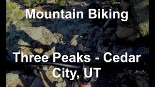
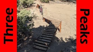
Desert type riding in a BLM multi-use area. Numerous slick rock options and regular single track trails through some beautiful juniper covered canyons. Sandy areas have really fun raised bridge options and some trails are super technical rock gardens.

Trail Supporters
  • BLM
    BLM
    Land Manager
Local Trail Association
Traditionally Indigenous Territory

Recent Activity on Trail

Past Week
  • 1 rides
  • 12 miles average
6 Months
  • 24 rides
  • 14 miles avg distance
All
  • 115 rides
  • Last: Jun 16, 2026
c1c2c3c4
January
February
March
April
May
June
July
August
September
October
November
December
update trails status or condition

Three Peaks Trail Reports

statusdatedescription
Jun 16, 2026 @ 7:55am (America/Phoenix)
3 days
First Wooden Bridge south of Petrified Whales starting to fall off of base.
Jun 4, 2026 @ 9:50am (America/Denver)
Jun 4, 2026
reporter Brackets are broken
Apr 8, 2026 @ 2:11pm (America/Denver)
Apr 8, 2026
Feb 25, 2026 @ 6:34pm (America/Denver)
Feb 25, 2026
Mostly dry. A few soft spots here and there.
Feb 4, 2026 @ 10:20am (America/Denver)
Feb 4, 2026
Please avoid soft/muddy trails
more »
Status:
on Jun 16, 2026
Ideal
Avg: 3.91 (7 votes)
Your vote: 0

view (445)
close
3D
Trail Conditions
  • Unknown
  • Snow Groomed
  • Snow Packed
  • Snow Covered
  • Snow Cover Partial
  • Freeze/thaw Cycle
  • Icy
  • Prevalent Mud
  • Wet
  • Variable
  • Ideal
  • Dry
  • Very Dry
Trail Flow (Ridden Direction)
Trailforks scans users ridelogs to determine the most popular direction each trail is ridden. A good flowing trail network will have most trails flowing in a single direction according to their intension.
The colour categories are based on what percentage of riders are riding a trail in its intended direction.
  • > 96%
  • > 90%
  • > 80%
  • > 70%
  • > 50%
  • < 50%
  • bi-directional trail
  • no data
Trail Last Ridden
Trailforks scans ridelogs to determine the last time a trail was ridden.
  • < 2 days
  • < 1 week
  • < 2 weeks
  • < 1 month
  • < 6 months
  • > 6 months
Trail Ridden Direction
The intended direction a trail should be ridden.
  • Downhill Only
  • Downhill Primary
  • Both Directions
  • Uphill Primary
  • Uphill Only
  • One Direction
Contribute Details
Colors indicate trail is missing specified detail.
  • Description
  • Photos
  • Description & Photos
  • Videos
Trail Popularity ?
Trailforks scans ridelogs to determine which trails are ridden the most in the last 9 months. Trails are compared with nearby trails in the same city region with a possible 25 colour shades. Think of this as a heatmap, more rides = more kinetic energy = warmer colors.
  • most popular
  • popular
  • less popular
  • not popular
ATV/ORV/OHV Filter
Max Vehicle Width
inches
US Cell Coverage
Legend
cell carrier legend

Radar Time
Activity Recordings
Trailforks uses anonymized public activity data. ?
Activity Recordings
Trailforks uses anonymized public activity data. ?
Personal Heatmap
Activity Types
all / none
Options
2
Date range month
Winter Trails
Warning A routing network for winter maps does not exist. Selecting trails using the winter trails layer has been disabled.
Missing Trails
Most Popular
Least Popular
Trails are colored based on popularity. The more popular a trail is, the more red. Less popular trails trend towards green.
Jump Magnitude Heatmap
Heatmap of where riders jump on trails. Zoom in to see individual jumps, click circles to view jump details.
BC Backroad Status

Service Road Atlas is a free to use, community-driven service for viewing and creating reports on the numerous back-country service roads around B.C. and Alberta.

map legend
Slope Aspect
Direction the slope faces
Flat N NE E SE S SW W NW
Trails Deemphasized
Trails are shown in grey.
disable
Only show trails with no bike usage.
Enable
Suggested Layers
Based on selected activity type

    Save the current map location and zoom level as your default home location whenever this page is loaded.

    Save
        Directions to three-peaks trailhead (37.774700, -113.198900)

        Photos

        26 more »
        19 |
        Jun 4, 2026 @ 11:05am
        Jun 4, 2026
        29 |
        Jun 4, 2026 @ 8:54am
        Jun 4, 2026
        24 |
        Jun 4, 2026 @ 8:51am
        Jun 4, 2026
        16 |
        Jun 4, 2026 @ 8:48am
        Jun 4, 2026

        Videos

        3 more »
        youtuber Three peaks recreation area has ROCKS!
        7:50 | 641 | Oct 10, 2019 , Cedar City
        Mountain Biking Three Peaks Loop
        19:23 | 235 | Aug 19, 2022 , Cedar City
        Three Peaks Best Wood & Rock Features!
        14:03 | 235 | Feb 8, 2021 , Cedar City

        Routes with this trail

        4.2 11 miles 841 ft 14 Loop
        You want the full experience? Well, take the time and ride this loop. Get ready for some tough climbs and...
        4.0 17 miles 1,746 ft 14 Loop
        Three Peaks loop of advanced trails.
        12 miles 918 ft 43 Loop
        This is a fun loop in the area. It starts off with some moderate tech, then more advanced tech riding on...

        Reviews / Comments

        No reviews yet, be the first to write a review or ask a question.
        Use trail reports to comment on trail conditions.


        We hope you've been enjoying Trailforks!

        Create a FREE account to view trail comments and much more.

        • By toddTF Pro Trailforks & contributors
        • #11807 - 6,029 views

        Frequently Asked Questions About Three Peaks

        Where is Three Peaks located?
        Three Peaks is located in Three Peaks Trail System, Cedar City, Utah, United States. It is part of the Three Peaks Trail System trail network. The trailhead is located at coordinates 37.7747, -113.1989.
        How hard is Three Peaks?
        Three Peaks is rated as Blue difficulty. The average grade is 0.6%.
        What is the elevation gain for Three Peaks?
        Three Peaks has 618 ft of elevation gain. The trail has 461 ft of elevation descent. The elevation ranges from 5,684 ft to 6,057 ft.
        How long is Three Peaks?
        Three Peaks is 4.8 miles long. The trail type is singletrack.

        Hit the Trail

        Open in App

        Get this trail on your phone instantly.
        open trail in app

        Download Trail

        Save to wishlist, Garmin & download.
        save the trail

        Find Related Routes

        Find routes and users activities that include this trail.
        find routes for this trail

        You must enter a description before submitting.