more stats
4,908 ft
Distance
17 ft
Climb
-29 ft
Descent
00:11:00
Avg time
-13 ft
Altitude change
80 ft
Altitude min
98 ft
Altitude max
97 ft
Altitude start
85 ft
Altitude end
-0.3%
Grade
-6%
Grade max
6.5%
Grade min
771 ft
Distance climb
1,385 ft
Distance down
2,753 ft
Distance flat
00:11:00
Avg time

Thrilla Details

  • Activities
    • Mountain Bike
    • Winter Fat Bike
    • Hike
    • Trail Running
  • Riding Area
    Cunningham Park
    Queens, New York
  • Difficulty Rating
  • Voted Difficulty
    Black Diamond (2 votes)
  • Local Popularity
    80 in Mountain Biking [+]
    • 95 in Trail Running
    • 60 in Hiking
  • Global Ranking
    #31870 in Mountain Biking [+]
    • #20508 in Trail Running
    • #22783 in Hiking
  • Trail Type
    Singletrack
  • Bike Type
    AM, XC, Fat
  • Direction
    One Direction
    Popular Direction Shown
  • Climb Difficulty
    Black Diamond
  • Physical Rating
    Hard
  • Trail Visibility
    Sometimes hard to follow
  • Dogs Allowed
    Yes
  • eBike Allowed
  • TTFs on Trail
    Jump, Log Ride
  • Land Owner
    New York Citi Parks

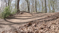
Thrilla starts with a few ramps to launch or roll then twists it's way through the jungle of greenery constantly going up and down a few tiny hills which brings you to the play station where there are three different sized jumps to practice on and a log ride. After that it swoops through the terrain crossing the west side connector bring you to a few more drops until you reach the pump tracks, one small for beginners and one large of experts. Please don't pedal on the pump track, you need to pump your bike for flow. After that you head up and out then down another jump and log rollover before joining the green loop.

Disclaimer

Use trails at your own risk. Hidden hazards may exist.

Local Trail Association
Traditionally Indigenous Territory

Recent Activity on Trail

Past Week
  • 3 rides
  • 6 miles average
6 Months
  • 99 rides
  • 8 miles avg distance
All
  • 2,246 rides
  • Last: Jun 21, 2026
c1c2c3c4
January
February
March
April
May
June
July
August
September
October
November
December
update trails status or condition

Thrilla Trail Reports

statusdatedescription
May 1, 2026 @ 4:03pm (America/New_York)
May 1, 2026
Re-installed signs that were ripped out. Used concrete to hold them in place.
Dec 23, 2025 @ 3:52pm (America/New_York)
Dec 23, 2025
Dug new drains at PlayStation
Nov 20, 2025 @ 1:13pm (America/New_York)
Nov 20, 2025
Leafy
Jan 2, 2025 @ 3:39am
Jan 2, 2025
Build up a roller on the pump track. First trail work of 2025 !
Dec 23, 2024 @ 9:53am
Dec 23, 2024
The main trunk & branch are still there... not sure if this is a planned new log-over.
more »
Status:
on May 1, 2026
Avg: 4.13 (9 votes)
Your vote: 0

view (7,541)
close
3D
Trail Conditions
  • Unknown
  • Snow Groomed
  • Snow Packed
  • Snow Covered
  • Snow Cover Partial
  • Freeze/thaw Cycle
  • Icy
  • Prevalent Mud
  • Wet
  • Variable
  • Ideal
  • Dry
  • Very Dry
Trail Flow (Ridden Direction)
Trailforks scans users ridelogs to determine the most popular direction each trail is ridden. A good flowing trail network will have most trails flowing in a single direction according to their intension.
The colour categories are based on what percentage of riders are riding a trail in its intended direction.
  • > 96%
  • > 90%
  • > 80%
  • > 70%
  • > 50%
  • < 50%
  • bi-directional trail
  • no data
Trail Last Ridden
Trailforks scans ridelogs to determine the last time a trail was ridden.
  • < 2 days
  • < 1 week
  • < 2 weeks
  • < 1 month
  • < 6 months
  • > 6 months
Trail Ridden Direction
The intended direction a trail should be ridden.
  • Downhill Only
  • Downhill Primary
  • Both Directions
  • Uphill Primary
  • Uphill Only
  • One Direction
Contribute Details
Colors indicate trail is missing specified detail.
  • Description
  • Photos
  • Description & Photos
  • Videos
Trail Popularity ?
Trailforks scans ridelogs to determine which trails are ridden the most in the last 9 months. Trails are compared with nearby trails in the same city region with a possible 25 colour shades. Think of this as a heatmap, more rides = more kinetic energy = warmer colors.
  • most popular
  • popular
  • less popular
  • not popular
ATV/ORV/OHV Filter
Max Vehicle Width
inches
US Cell Coverage
Legend
cell carrier legend

Radar Time
Activity Recordings
Trailforks uses anonymized public activity data. ?
Activity Recordings
Trailforks uses anonymized public activity data. ?
Personal Heatmap
Activity Types
all / none
Options
2
Date range month
Winter Trails
Warning A routing network for winter maps does not exist. Selecting trails using the winter trails layer has been disabled.
Missing Trails
Most Popular
Least Popular
Trails are colored based on popularity. The more popular a trail is, the more red. Less popular trails trend towards green.
Jump Magnitude Heatmap
Heatmap of where riders jump on trails. Zoom in to see individual jumps, click circles to view jump details.
BC Backroad Status

Service Road Atlas is a free to use, community-driven service for viewing and creating reports on the numerous back-country service roads around B.C. and Alberta.

map legend
Slope Aspect
Direction the slope faces
Flat N NE E SE S SW W NW
Trails Deemphasized
Trails are shown in grey.
disable
Only show trails with no bike usage.
Enable
Suggested Layers
Based on selected activity type

    Save the current map location and zoom level as your default home location whenever this page is loaded.

    Save
        Directions to thrilla trailhead (40.739210, -73.767170)

        Photos

        62 more »
        157 |
        Jun 9, 2023 @ 2:33pm
        Jun 9, 2023
        172 |
        Oct 11, 2022 @ 8:37am
        Oct 11, 2022
        238 |
        Oct 11, 2022 @ 8:37am
        Oct 11, 2022
        191 |
        Oct 11, 2022 @ 8:37am
        Oct 11, 2022

        Videos

        3 more »
        no bagels
        0:09 | | Apr 24, 2019 , Queens
        no bagels
        0:09 | | Apr 23, 2019 , Queens
        no bagels
        0:09 | | Apr 23, 2019 , Queens

        Routes with this trail

        5.0 8 miles 280 ft 16 Loop
        This route included ALL trails at Cunningham Park.

        1 Review & Comments


        We hope you've been enjoying Trailforks!

        Create a FREE account to view trail comments and much more.

        Frequently Asked Questions About Thrilla

        Where is Thrilla located?
        Thrilla is located in Cunningham Park, Queens, New York, United States. It is part of the Cunningham Park trail network. The trailhead is located at coordinates 40.73921, -73.76717.
        How hard is Thrilla?
        Thrilla is rated as Black Diamond difficulty. The physical rating is Hard. The average grade is 0.3%. The climb difficulty is rated Black Diamond.
        What is the elevation gain for Thrilla?
        Thrilla has 17 ft of elevation gain. The trail has 29 ft of elevation descent. The elevation ranges from 80 ft to 98 ft.
        Is Thrilla a point to point trail?
        Yes, Thrilla is a point to point trail. The direction is One Direction. The trail type is singletrack.

        Hit the Trail

        Open in App

        Get this trail on your phone instantly.
        open trail in app

        Download Trail

        Save to wishlist, Garmin & download.
        save the trail

        Find Related Routes

        Find routes and users activities that include this trail.
        find routes for this trail

        You must enter a description before submitting.