more stats
2.4 miles
Distance
18 ft
Climb
-1,611 ft
Descent
00:19:33
Avg time
-1,593 ft
Altitude change
1,278 ft
Altitude min
2,883 ft
Altitude max
2,870 ft
Altitude start
1,280 ft
Altitude end
-12.6%
Grade
-36.3%
Grade max
10.6%
Grade min
295 ft
Distance climb
2 miles
Distance down
807 ft
Distance flat
00:19:33
Avg time

Thrillium Details

  • Activities
    • Mountain Bike
  • Riding Area
    Yacolt Burn State Forest
    Battle Ground, Washington
  • Difficulty Rating
  • Voted Difficulty
    Black Diamond (1 vote)
  • Local Popularity
    90 in Mountain Biking
  • Global Ranking
    #1412 in Mountain Biking
  • Trail Type
    Singletrack
  • Bike Type
    DH, AM
  • Direction
    Downhill Primary
    Popular Direction Shown
  • Physical Rating
    Hard
  • Trail Visibility
    Always easy to follow
  • Season
    Year Round, Snow closures do exist.
  • Dogs Allowed
    Yes
  • eBike Allowed
  • TTFs on Trail
    Berm, Jump, Rock Garden
  • Ride in Rain
    Yes
  • Year Opened
    2012
  • Land Owner

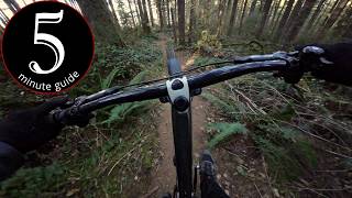
Thrillium is one of the Pacific Northwest's premier DH trails. It features high speed berms and many large tabled jumps that "intermediate" skilled riders can roll. It is a popular trail to shuttle, but the top can also be accessed from the Yacolt Burn TH parking area. Note that during winter the gate 300' below the lot is locked. The trail will not be closed, but vehicle access is prohibited to the lot.

Access Info

Google Map URL https://goo.gl/maps/BZp6s

Disclaimer

The trail invites speed so riders are encouraged to make the first descent with caution and thoroughly scout all features.

Local Trail Association
Traditionally Indigenous Territory

Recent Activity on Trail

Past Week
  • 14 rides
  • 21 miles average
6 Months
  • 45 rides
  • 17 miles avg distance
All
  • 331 rides
  • Last: Jun 29, 2026
c1c2c3c4
January
February
March
April
May
June
July
August
September
October
November
December
update trails status or condition

Thrillium Trail Reports

statusdatedescription
May 28, 2026 @ 11:05am (America/Vancouver)
May 28, 2026
May 18, 2026 @ 3:55pm (America/Los_Angeles)
May 18, 2026
It's great top to bottom
May 9, 2026 @ 1:41pm (America/Vancouver)
May 9, 2026
Apr 7, 2026 @ 7:39pm (America/Los_Angeles)
Apr 7, 2026
Absolutely perfect - rode from the top to L1050 which is my normal route, hard to find a better section of trail then this
Feb 5, 2026 @ 5:29pm (America/Los_Angeles)
Feb 5, 2026
Riding perfect on the top half!
more »
Status:
on May 28, 2026
Ideal
Avg: 4.67 (41 votes)
Your vote: 0

view (2,617)
close
3D
Trail Conditions
  • Unknown
  • Snow Groomed
  • Snow Packed
  • Snow Covered
  • Snow Cover Partial
  • Freeze/thaw Cycle
  • Icy
  • Prevalent Mud
  • Wet
  • Variable
  • Ideal
  • Dry
  • Very Dry
Trail Flow (Ridden Direction)
Trailforks scans users ridelogs to determine the most popular direction each trail is ridden. A good flowing trail network will have most trails flowing in a single direction according to their intension.
The colour categories are based on what percentage of riders are riding a trail in its intended direction.
  • > 96%
  • > 90%
  • > 80%
  • > 70%
  • > 50%
  • < 50%
  • bi-directional trail
  • no data
Trail Last Ridden
Trailforks scans ridelogs to determine the last time a trail was ridden.
  • < 2 days
  • < 1 week
  • < 2 weeks
  • < 1 month
  • < 6 months
  • > 6 months
Trail Ridden Direction
The intended direction a trail should be ridden.
  • Downhill Only
  • Downhill Primary
  • Both Directions
  • Uphill Primary
  • Uphill Only
  • One Direction
Contribute Details
Colors indicate trail is missing specified detail.
  • Description
  • Photos
  • Description & Photos
  • Videos
Trail Popularity ?
Trailforks scans ridelogs to determine which trails are ridden the most in the last 9 months. Trails are compared with nearby trails in the same city region with a possible 25 colour shades. Think of this as a heatmap, more rides = more kinetic energy = warmer colors.
  • most popular
  • popular
  • less popular
  • not popular
ATV/ORV/OHV Filter
Max Vehicle Width
inches
US Cell Coverage
Legend
cell carrier legend

Radar Time
Activity Recordings
Trailforks uses anonymized public activity data. ?
Activity Recordings
Trailforks uses anonymized public activity data. ?
Personal Heatmap
Activity Types
all / none
Options
2
Date range month
Winter Trails
Warning A routing network for winter maps does not exist. Selecting trails using the winter trails layer has been disabled.
Missing Trails
Most Popular
Least Popular
Trails are colored based on popularity. The more popular a trail is, the more red. Less popular trails trend towards green.
Jump Magnitude Heatmap
Heatmap of where riders jump on trails. Zoom in to see individual jumps, click circles to view jump details.
BC Backroad Status

Service Road Atlas is a free to use, community-driven service for viewing and creating reports on the numerous back-country service roads around B.C. and Alberta.

map legend
Slope Aspect
Direction the slope faces
Flat N NE E SE S SW W NW
Trails Deemphasized
Trails are shown in grey.
disable
Only show trails with no bike usage.
Enable
Suggested Layers
Based on selected activity type

    Save the current map location and zoom level as your default home location whenever this page is loaded.

    Save
        Directions to thrillium trailhead (45.722270, -122.313710)

        Photos

        250 more »
        1,668 |
        Jul 5, 2016 @ 3:13pm
        Jul 5, 2016
        1,390 |
        Jul 26, 2015 @ 11:13pm
        Jul 26, 2015
        2,032 |
        Jan 8, 2017 @ 9:01am
        Jan 8, 2017
        8,900 |
        May 27, 2015 @ 1:47am
        May 27, 2015

        Videos

        66 more »
        youtuber 5 minute guide to THE Thrillium!
        5:00 | 546 | Apr 7, 2025 , Battle Ground
        youtuber Best DH Trail In Southwest Washington? (Thrillium)
        12:03 | 1873 | Jan 3, 2021 , Battle Ground
        youtuber Thrillium 2019 (Battle Ground, Washington)...
        12:55 | 2058 | Jul 7, 2019 , Battle Ground
        Short and Rugged | Upper Thrillium
        84 | Jun 25, 2025 , Battle Ground

        Routes with this trail

        5.0 45 miles 9,258 ft 12 Loop
        This is a tough route that I experimented with, failing after the first day as it was dumping rain and our...
        24 miles 5,458 ft 12
        21 miles 4,809 ft 11

        16 Reviews & Comments


        We hope you've been enjoying Trailforks!

        Create a FREE account to view trail comments and much more.

        • By northwestdhdad EMBA-SW & contributors
        • #3333 - 47,032 views

        Frequently Asked Questions About Thrillium

        Where is Thrillium located?
        Thrillium is located in Yacolt Burn State Forest, Battle Ground, Washington, United States. It is part of the Yacolt Burn State Forest trail network. The trailhead is located at coordinates 45.72227, -122.31371.
        How hard is Thrillium?
        Thrillium is rated as Black Diamond difficulty. The physical rating is Hard. The average grade is 12.6%.
        What is the elevation gain for Thrillium?
        Thrillium has 18 ft of elevation gain. The trail has 1,611 ft of elevation descent. The elevation ranges from 1,278 ft to 2,883 ft.
        Is Thrillium a point to point trail?
        Thrillium is not a point to point trail. The direction is Downhill Primary. The trail type is singletrack.

        Hit the Trail

        Open in App

        Get this trail on your phone instantly.
        open trail in app

        Download Trail

        Save to wishlist, Garmin & download.
        save the trail

        Find Related Routes

        Find routes and users activities that include this trail.
        find routes for this trail

        You must enter a description before submitting.