more stats
4,902 ft
Distance
-563 ft
Descent
00:03:14
Avg time
-564 ft
Altitude change
9,772 ft
Altitude min
10,336 ft
Altitude max
10,336 ft
Altitude start
9,770 ft
Altitude end
-11.5%
Grade
-42.6%
Grade max
-0.8%
Grade min
4,777 ft
Distance down
121 ft
Distance flat
00:03:14
Avg time

Timeline Details

  • Activities
    • Mountain Bike
  • Riding Area
    Crested Butte Mountain Bike Park
    Crested Butte, Colorado
  • Difficulty Rating
  • Voted Difficulty
    Double Black Diamond (1 vote)
  • Local Popularity
    50 in Mountain Biking
  • Global Ranking
    #103637 in Mountain Biking
  • Trail Type
    Singletrack
  • Bike Type
    DH
  • Season
    June-Sept
  • Dogs Allowed
    Yes
  • TTFs on Trail
    Bridge, Jump, Rock Face, Wallride
  • Ride in Rain
    Yes

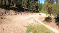
This trail has been upgraded as of 2025 with bigger and better jumps. The entire run finishes as Timeline, but you now have the option to do the really big pro level jumps on Time Warp. The tables are amazing, sculpted, with a lot of variety. The revamped the lower section which used to be called Time Table, to be a continuation of this trail with three big table tops. The first 2 are straight on and flow well, the last one is a bit of a left turn and boots you higher then the first two.

Access Info

Ride the Red Lady Express. The start of the trail will be well-marked at the top (to the left).

Trail Supporters

  • USFS
    Land Manager

Bike Park

Traditionally Indigenous Territory

Recent Activity on Trail

Past Week
  • 1 rides
  • 31 miles average
6 Months
  • 1 rides
  • 31 miles avg distance
All
  • 92 rides
  • Last: Jun 14, 2026
c1c2c3c4
January
February
March
April
May
June
July
August
September
October
November
December
update trails status or condition

Timeline Trail Reports

statusdatedescription
May 14, 2024 @ 9:51am
May 14, 2024
May 14, 2024 @ 9:08am
May 14, 2024
Jun 27, 2022 @ 1:25pm
Jun 27, 2022
Dec 17, 2019 @ 7:52pm
Dec 17, 2019
Bike Park closed for the season, see you in 2020! :)
Dec 17, 2019 @ 7:38pm
Dec 17, 2019
Bike Park closed for the season, see you in 2020! :)
more »
Status:
on May 14, 2024
Avg: 4.26 (5 votes)
Your vote: 0

view (1,037)
close
3D
Trail Conditions
  • Unknown
  • Snow Groomed
  • Snow Packed
  • Snow Covered
  • Snow Cover Partial
  • Freeze/thaw Cycle
  • Icy
  • Prevalent Mud
  • Wet
  • Variable
  • Ideal
  • Dry
  • Very Dry
Trail Flow (Ridden Direction)
Trailforks scans users ridelogs to determine the most popular direction each trail is ridden. A good flowing trail network will have most trails flowing in a single direction according to their intension.
The colour categories are based on what percentage of riders are riding a trail in its intended direction.
  • > 96%
  • > 90%
  • > 80%
  • > 70%
  • > 50%
  • < 50%
  • bi-directional trail
  • no data
Trail Last Ridden
Trailforks scans ridelogs to determine the last time a trail was ridden.
  • < 2 days
  • < 1 week
  • < 2 weeks
  • < 1 month
  • < 6 months
  • > 6 months
Trail Ridden Direction
The intended direction a trail should be ridden.
  • Downhill Only
  • Downhill Primary
  • Both Directions
  • Uphill Primary
  • Uphill Only
  • One Direction
Contribute Details
Colors indicate trail is missing specified detail.
  • Description
  • Photos
  • Description & Photos
  • Videos
Trail Popularity ?
Trailforks scans ridelogs to determine which trails are ridden the most in the last 9 months. Trails are compared with nearby trails in the same city region with a possible 25 colour shades. Think of this as a heatmap, more rides = more kinetic energy = warmer colors.
  • most popular
  • popular
  • less popular
  • not popular
ATV/ORV/OHV Filter
Max Vehicle Width
inches
US Cell Coverage
Legend
cell carrier legend

Radar Time
Activity Recordings
Trailforks uses anonymized public activity data. ?
Activity Recordings
Trailforks uses anonymized public activity data. ?
Personal Heatmap
Activity Types
all / none
Options
2
Date range month
Winter Trails
Warning A routing network for winter maps does not exist. Selecting trails using the winter trails layer has been disabled.
Missing Trails
Most Popular
Least Popular
Trails are colored based on popularity. The more popular a trail is, the more red. Less popular trails trend towards green.
Jump Magnitude Heatmap
Heatmap of where riders jump on trails. Zoom in to see individual jumps, click circles to view jump details.
BC Backroad Status

Service Road Atlas is a free to use, community-driven service for viewing and creating reports on the numerous back-country service roads around B.C. and Alberta.

map legend
Slope Aspect
Direction the slope faces
Flat N NE E SE S SW W NW
Trails Deemphasized
Trails are shown in grey.
disable
Only show trails with no bike usage.
Enable
Suggested Layers
Based on selected activity type

    Save the current map location and zoom level as your default home location whenever this page is loaded.

    Save
        Directions to timeline trailhead (38.897610, -106.945790)

        Photos

        26 more »
        186 |
        Jun 26, 2018 @ 9:22pm
        Jun 26, 2018
        164 |
        Jun 26, 2018 @ 9:22pm
        Jun 26, 2018
        172 |
        Jun 26, 2018 @ 9:23pm
        Jun 26, 2018
        272 |
        Jun 26, 2018 @ 9:23pm
        Jun 26, 2018

        Videos

        8 more »
        youtuber 2 Steps Forward, 1 Step Back - Evolution Bike...
        9:24 | 431 | Oct 17, 2018 , Crested Butte
        John's crash at Crested Butte bike park
        0:10 | 158 | Aug 29, 2021 , Crested Butte
        RAW | Timeline Trail - Crested Butte, CO
        0:58 | 248 | Nov 7, 2019 , Crested Butte
        Red Mcintosh- One Ripping S.O.B.
        0:43 | 276 | Aug 21, 2015 , Crested Butte

        Routes with this trail

        3 miles 923 ft 3

        3 Reviews & Comments


        We hope you've been enjoying Trailforks!

        Create a FREE account to view trail comments and much more.

        • By crestedbuttemountainbikepark & contributors
        • #7541 - 3,331 views

        Frequently Asked Questions About Timeline

        Where is Timeline located?
        Timeline is located in CBMR/Evolution Bike Park, Crested Butte, Colorado, United States. It is part of the CBMR/Evolution Bike Park trail network. The trailhead is located at coordinates 38.89761, -106.94579.
        How hard is Timeline?
        Timeline is rated as Double Black Diamond difficulty. The average grade is 11.5%.
        What is the elevation gain for Timeline?
        The trail has 563 ft of elevation descent. The elevation ranges from 9,772 ft to 10,336 ft.
        How long is Timeline?
        Timeline is 4,902 ft long. The trail type is singletrack.

        Hit the Trail

        Open in App

        Get this trail on your phone instantly.
        open trail in app

        Download Trail

        Save to wishlist, Garmin & download.
        save the trail

        Find Related Routes

        Find routes and users activities that include this trail.
        find routes for this trail

        You must enter a description before submitting.