more stats
2.4 miles
Distance
200 ft
Climb
-381 ft
Descent
00:38:21
Avg time
-182 ft
Altitude change
4,602 ft
Altitude min
4,887 ft
Altitude max
4,787 ft
Altitude start
4,606 ft
Altitude end
-1.4%
Grade
-31%
Grade max
25.5%
Grade min
4,278 ft
Distance climb
1 mile
Distance down
2,487 ft
Distance flat
00:38:21
Avg time

Topp Notch Details

  • Activities
    • Mountain Bike
    • E-Bike
    • Hike
    • Trail Running
  • Riding Area
  • Difficulty Rating
  • Voted Difficulty
    Black Diamond (1 vote)
  • Local Popularity
    95 in Mountain Biking [+]
    • 100 in E-Biking
    • 80 in Trail Running
    • 75 in Hiking
  • Global Ranking
    #296 in Mountain Biking [+]
    • #244 in Trail Running
    • #1271 in Hiking
  • Trail Type
    Singletrack
  • Bike Type
    AM, XC
  • Direction
    Downhill Primary
    Popular Direction Shown
  • Physical Rating
    Moderate
  • Dogs Allowed
    Yes
  • eBike Allowed
  • TTFs on Trail
    Berm, Bridge, Drop, Jump, Rock Face, Rock Garden, Skinny
  • Year Opened
    2014
  • Land Owner
    Banff National Park

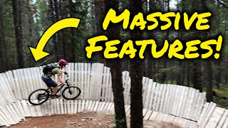
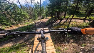
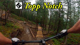
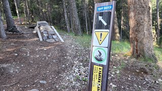
Topp Notch begins with a squirrel catcher [mandatory feature] meant to weed out the less experienced. If you cannot ride this feature, head back down to Star Wars. Once past the entry on Topp Notch, the trail will climb several switchbacks towards the first large feature, the Big Daddy corner. What follows next can only be described as incredible flow along some challenging technical trail features (TTFs). Most TTFs are pretty wide, and very well built. Some new features require jumping skills but all have a "ride around" and are marked with black and blue arrows. The end of the trail rolls right into Return of the Jedi so you can climb back up.

Built entirely by hand over 3 years with 3500+ hours of volunteer labour, this trail is named after Doug Topp, former president of the Bow Valley Mountain Bike Alliance and all-around good guy. Buy him a beer.

Access Info

The access to Topp Notch is found west of the Star Wars trailhead, accessible from Tunnel Mountain Road and located across (south) from Buffalo Mountain Lodge. As you approach the trailhead for Star Wars (30 metres in), continue right (west) and past the entry to Star Wars up the trail. From here, there are markers and arrows pointing you in the direction of Topp Notch.

Local Trail Association

Recent Activity on Trail

Past Week
  • 6 rides
  • 6 miles average
6 Months
  • 34 rides
  • 10 miles avg distance
All
  • 517 rides
  • Last: Jun 19, 2026
c1c2c3c4
January
February
March
April
May
June
July
August
September
October
November
December
update trails status or condition

Topp Notch Trail Reports

statusdatedescription
Jun 14, 2026 @ 12:03pm (America/Creston)
Jun 14, 2026
Jun 4, 2026 @ 12:10am (America/Edmonton)
Jun 3, 2026
Small tree down across trail, can navigate over or around
May 8, 2026 @ 3:33pm (America/Edmonton)
May 8, 2026
raked clean for most of the trail by a VERY fantastic trail volunteer. thanks!
May 7, 2026 @ 9:10am (America/Edmonton)
May 7, 2026
All clear! Expect ongoing trail work this spring.
May 3, 2026 @ 3:32pm (America/Edmonton)
May 3, 2026
Some ice patches - better off walking to avoid cutting up the wet soil. Tree down - needs a proper saw, it required some commitment to bunny hop it.
more »
Status:
on Jun 14, 2026
Ideal
Avg: 4.17 (65 votes)
Your vote: 0

view (3,586)
close
3D
Trail Conditions
  • Unknown
  • Snow Groomed
  • Snow Packed
  • Snow Covered
  • Snow Cover Partial
  • Freeze/thaw Cycle
  • Icy
  • Prevalent Mud
  • Wet
  • Variable
  • Ideal
  • Dry
  • Very Dry
Trail Flow (Ridden Direction)
Trailforks scans users ridelogs to determine the most popular direction each trail is ridden. A good flowing trail network will have most trails flowing in a single direction according to their intension.
The colour categories are based on what percentage of riders are riding a trail in its intended direction.
  • > 96%
  • > 90%
  • > 80%
  • > 70%
  • > 50%
  • < 50%
  • bi-directional trail
  • no data
Trail Last Ridden
Trailforks scans ridelogs to determine the last time a trail was ridden.
  • < 2 days
  • < 1 week
  • < 2 weeks
  • < 1 month
  • < 6 months
  • > 6 months
Trail Ridden Direction
The intended direction a trail should be ridden.
  • Downhill Only
  • Downhill Primary
  • Both Directions
  • Uphill Primary
  • Uphill Only
  • One Direction
Contribute Details
Colors indicate trail is missing specified detail.
  • Description
  • Photos
  • Description & Photos
  • Videos
Trail Popularity ?
Trailforks scans ridelogs to determine which trails are ridden the most in the last 9 months. Trails are compared with nearby trails in the same city region with a possible 25 colour shades. Think of this as a heatmap, more rides = more kinetic energy = warmer colors.
  • most popular
  • popular
  • less popular
  • not popular
ATV/ORV/OHV Filter
Max Vehicle Width
inches
US Cell Coverage
Legend
cell carrier legend

Radar Time
Activity Recordings
Trailforks uses anonymized public activity data. ?
Activity Recordings
Trailforks uses anonymized public activity data. ?
Personal Heatmap
Activity Types
all / none
Options
2
Date range month
Winter Trails
Warning A routing network for winter maps does not exist. Selecting trails using the winter trails layer has been disabled.
Missing Trails
Most Popular
Least Popular
Trails are colored based on popularity. The more popular a trail is, the more red. Less popular trails trend towards green.
Jump Magnitude Heatmap
Heatmap of where riders jump on trails. Zoom in to see individual jumps, click circles to view jump details.
BC Backroad Status

Service Road Atlas is a free to use, community-driven service for viewing and creating reports on the numerous back-country service roads around B.C. and Alberta.

map legend
Slope Aspect
Direction the slope faces
Flat N NE E SE S SW W NW
Trails Deemphasized
Trails are shown in grey.
disable
Only show trails with no bike usage.
Enable
Suggested Layers
Based on selected activity type

    Save the current map location and zoom level as your default home location whenever this page is loaded.

    Save
        Directions to topp-notch trailhead (51.181840, -115.552820)

        Photos

        75 more »
        1,976 |
        Jun 25, 2016 @ 6:58pm
        Jun 25, 2016
        1,963 |
        Jun 25, 2016 @ 6:58pm
        Jun 25, 2016
        190 |
        Sep 13, 2024 @ 7:24pm
        Sep 13, 2024
        226 |
        Jun 13, 2024 @ 9:28am
        Jun 13, 2024

        Videos

        14 more »
        youtuber Banff's Best Mountain Bike Trails (Topp Notch...
        9:26 | 1475 | Aug 24, 2021 , Banff
        Flow, Tech, and Big Features: Topp Notch...
        7:49 | 178 | Aug 4, 2025 , Banff
        youtuber Maybe the best MTB trail in Alberta? Topp Notch
        11:50 | 335 | Sep 13, 2024 , Banff
        Topp Notch ◇ at Banff
        22:04 | 524 | Sep 22, 2022 , Banff

        Trail Lists

        Routes with this trail

        18 miles 1,118 ft 11 Point to Point
        Hopefully a good guide to riding all the tunnel bench trails in terms of the best/most fun direction to...
        14 miles 946 ft 8
        A Solid ~25k loop in Banff! Great to do if you're staying in town or camping
        1.0 162 miles 19,314 ft 106 Loop
        Think you've got what it takes to tackle this monster ride? This is the ultimate link-up of single track...

        33 Reviews & Comments


        We hope you've been enjoying Trailforks!

        Create a FREE account to view trail comments and much more.

        • By megandTF Pro & contributors
        • #10026 - 36,405 views

        Frequently Asked Questions About Topp Notch

        Where is Topp Notch located?
        Topp Notch is located in Tunnel Mountain Bench Area, Banff, Alberta, Canada. It is part of the Tunnel Mountain Bench Area trail network. The trailhead is located at coordinates 51.18184, -115.55282.
        How hard is Topp Notch?
        Topp Notch is rated as Black Diamond difficulty. The physical rating is Moderate. The average grade is 1.4%.
        What is the elevation gain for Topp Notch?
        Topp Notch has 61 m of elevation gain. The trail has 116 m of elevation descent. The elevation ranges from 1,403 m to 1,490 m.
        Is Topp Notch a point to point trail?
        Topp Notch is not a point to point trail. The direction is Downhill Primary. The trail type is singletrack.

        Hit the Trail

        Open in App

        Get this trail on your phone instantly.
        open trail in app

        Download Trail

        Save to wishlist, Garmin & download.
        save the trail

        Find Related Routes

        Find routes and users activities that include this trail.
        find routes for this trail

        You must enter a description before submitting.