more stats
2.4 miles
Distance
322 ft
Climb
-1,781 ft
Descent
00:32:59
Avg time
-1,460 ft
Altitude change
2,724 ft
Altitude min
4,203 ft
Altitude max
4,199 ft
Altitude start
2,740 ft
Altitude end
-11.378%
Grade
-68.983%
Grade max
43.959%
Grade min
2,618 ft
Distance climb
2 miles
Distance down
274 ft
Distance flat
00:32:59
Avg time

Trabuco Details

  • Activities
    • Mountain Bike
    • Hike
    • Trail Running
  • Riding Area
    Cleveland National Forest
    Mission Viejo, California
  • Difficulty Rating
  • Local Popularity
    5 in Mountain Biking [+]
    • 5 in Trail Running
    • 5 in Hiking
  • Global Ranking
    #153106 in Mountain Biking [+]
    • #137582 in Trail Running
    • #131200 in Hiking
  • Trail Type
    Singletrack
  • Bike Type
    AM, XC
  • Direction
    Both Directions
  • Climb Difficulty
    Black Diamond
  • Physical Rating
    Hard
  • Season
    Jan-Dec
  • Dogs Allowed
    Yes
  • Land Owner
    United States Forest Service

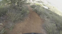
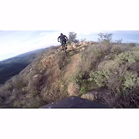
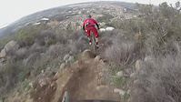
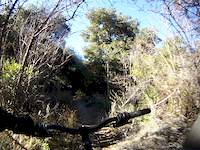
Singletrack trail that has a lot of loose rock in the middle part. the upper part is still fairly loose, but is also in the trees. Can be used as a climb or a downhill.

Access Info

From Holy jim parking lot: follow the road that continues up to the right. go over the bar across the single track at the next parking area. follow that single track until you see a sign for west horse their and trabuco. take the trabuco split. It will take you up to the main divide. From main divide: trabuco starts just to the right of the bar across the los pinos trail.

Trail Supporters

  • USFS
    Land Manager
Local Trail Association
Traditionally Indigenous Territory

Recent Activity on Trail

Past Week
  • 0 rides
  •  
6 Months
  • 0 rides
  •  
All
  • 5 rides
  • Last: Nov 18, 2023
c1c2c3c4
January
February
March
April
May
June
July
August
September
October
November
December
update trails status or condition

Trabuco Trail Reports

statusdatedescription
Aug 26, 2025 @ 8:58pm
Aug 26, 2025
Trail is closed as a result of the September 8 2024 Airport Fire
Apr 7, 2024 @ 7:35pm
Apr 7, 2024
Lotsa Poison OAK, trail closed still, no time for re opening
Apr 8, 2023 @ 9:12pm
Apr 8, 2023
04/01/2023 Trail remains CLOSED due to the Holy Jim Fire 2018. Trail is heavily damaged to non existent due to debris and water flows from 4 years...
Dec 22, 2021 @ 12:33pm
Dec 22, 2021
Trail still closed as of Dec 21, 2021
Apr 21, 2021 @ 1:20pm
Apr 21, 2021
reporter Remains closed due to Holy Fire until October 2021
more »
Status:
on Aug 26, 2025
Avg: 3.99 (4 votes)
Your vote: 0

view (126)
close
3D
Trail Conditions
  • Unknown
  • Snow Groomed
  • Snow Packed
  • Snow Covered
  • Snow Cover Partial
  • Freeze/thaw Cycle
  • Icy
  • Prevalent Mud
  • Wet
  • Variable
  • Ideal
  • Dry
  • Very Dry
Trail Flow (Ridden Direction)
Trailforks scans users ridelogs to determine the most popular direction each trail is ridden. A good flowing trail network will have most trails flowing in a single direction according to their intension.
The colour categories are based on what percentage of riders are riding a trail in its intended direction.
  • > 96%
  • > 90%
  • > 80%
  • > 70%
  • > 50%
  • < 50%
  • bi-directional trail
  • no data
Trail Last Ridden
Trailforks scans ridelogs to determine the last time a trail was ridden.
  • < 2 days
  • < 1 week
  • < 2 weeks
  • < 1 month
  • < 6 months
  • > 6 months
Trail Ridden Direction
The intended direction a trail should be ridden.
  • Downhill Only
  • Downhill Primary
  • Both Directions
  • Uphill Primary
  • Uphill Only
  • One Direction
Contribute Details
Colors indicate trail is missing specified detail.
  • Description
  • Photos
  • Description & Photos
  • Videos
Trail Popularity ?
Trailforks scans ridelogs to determine which trails are ridden the most in the last 9 months. Trails are compared with nearby trails in the same city region with a possible 25 colour shades. Think of this as a heatmap, more rides = more kinetic energy = warmer colors.
  • most popular
  • popular
  • less popular
  • not popular
ATV/ORV/OHV Filter
Max Vehicle Width
inches
US Cell Coverage
Legend
cell carrier legend

Radar Time
Activity Recordings
Trailforks uses anonymized public activity data. ?
Activity Recordings
Trailforks uses anonymized public activity data. ?
Personal Heatmap
Activity Types
all / none
Options
2
Date range month
Winter Trails
Warning A routing network for winter maps does not exist. Selecting trails using the winter trails layer has been disabled.
Missing Trails
Most Popular
Least Popular
Trails are colored based on popularity. The more popular a trail is, the more red. Less popular trails trend towards green.
Jump Magnitude Heatmap
Heatmap of where riders jump on trails. Zoom in to see individual jumps, click circles to view jump details.
BC Backroad Status

Service Road Atlas is a free to use, community-driven service for viewing and creating reports on the numerous back-country service roads around B.C. and Alberta.

map legend
Slope Aspect
Direction the slope faces
Flat N NE E SE S SW W NW
Trails Deemphasized
Trails are shown in grey.
disable
Only show trails with no bike usage.
Enable
Suggested Layers
Based on selected activity type

    Save the current map location and zoom level as your default home location whenever this page is loaded.

    Save
        Directions to trabuco trailhead (33.671450, -117.460200)

        Photos

        1 more »
        310 |
        May 30, 2015 @ 2:34pm
        May 30, 2015

        Videos

        5 more »
        Socal Mtb
        2:13 | 213 | Jan 22, 2016 , Mission Viejo
        Orange county mtb
        2:00 | 200 | Jan 22, 2016 , Mission Viejo
        Ripping some local steeps
        0:50 | 405 | Jan 21, 2016 , Mission Viejo
        Mid-Section of W. Horsethief
        2:37 | 110 | Jan 27, 2012 , Mission Viejo

        Routes with this trail

        4.0 20 miles 4,031 ft 8 Loop
        The loop consists of about 4,500 feet of climbing with several Hike-A-Bike sections. The whole loop will...
        5.0 9 miles 2,956 ft 8 Loop
        2-4 hour loop of one of the steepest trails in Southern California
        4.0 26 miles 4,697 ft 2 Loop
        Great loop in the Santa Ana's. Best done clockwise but either direction is possible.

        1 Review & Comments


        We hope you've been enjoying Trailforks!

        Create a FREE account to view trail comments and much more.

        • By iamenduro14 & contributors
        • #30410 - 2,655 views

        Frequently Asked Questions About Trabuco

        Where is Trabuco located?
        Trabuco is located in Cleveland National Forest, Mission Viejo, California, United States. It is part of the Cleveland National Forest trail network. The trailhead is located at coordinates 33.67145, -117.4602.
        How hard is Trabuco?
        Trabuco is rated as Blue difficulty. The physical rating is Hard. The average grade is 11.378%. The climb difficulty is rated Black Diamond.
        What is the elevation gain for Trabuco?
        Trabuco has 322 ft of elevation gain. The trail has 1,781 ft of elevation descent. The elevation ranges from 2,724 ft to 4,203 ft.
        Is Trabuco a point to point trail?
        Trabuco is not a point to point trail. The direction is Both Directions. The trail type is singletrack.

        Hit the Trail

        Open in App

        Get this trail on your phone instantly.
        open trail in app

        Download Trail

        Save to wishlist, Garmin & download.
        save the trail

        Find Related Routes

        Find routes and users activities that include this trail.
        find routes for this trail

        You must enter a description before submitting.