more stats
1,757 ft
Distance
61 ft
Climb
00:12:46
Avg time
61 ft
Altitude change
3,412 ft
Altitude min
3,473 ft
Altitude max
3,412 ft
Altitude start
3,473 ft
Altitude end
3.49%
Grade
-0.951%
Grade max
18.165%
Grade min
689 ft
Distance climb
1,068 ft
Distance flat
00:12:46
Avg time

Trail 10b Details

  • Activities
    • Mountain Bike
    • E-Bike
    • Horse
    • Hike
    • Trail Running
    • Snowshoe
  • Riding Area
    Jasper National Park
    Jasper, Alberta
  • Difficulty Rating
  • Local Popularity
    75 in Mountain Biking [+]
    • 5 in E-Biking
    • 80 in Trail Running
    • 90 in Hiking
    • 5 in Horseback
    • 5 in Snowshoeing
  • Global Ranking
    #154628 in Mountain Biking [+]
    • #76653 in Trail Running
    • #38489 in Hiking
    • #10264 in Horseback
    • #9673 in Snowshoeing
  • Blaze Color
  • Trail Type
    Singletrack
  • Bike Type
    AM, XC
  • Direction
    Both Directions
  • Climb Difficulty
    Black Diamond
  • Physical Rating
    Hard
  • Season
    May - Oct
  • Dogs Allowed
    Yes
  • eBike Allowed
    Yes up to Class 1
  • Land Owner

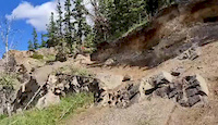
Alternate access to the Overlander trail via the Morro slabs. Starts with a sandy hike a bike about 15m up from the parking lot and then work your way through the goat and social trails across small technical rock features until the trail connects with Trail 10 - Overlander

Local Trail Association

Recent Activity on Trail

Past Week
  • 1 rides
  • 13 miles average
6 Months
  • 1 rides
  • 13 miles avg distance
All
  • 40 rides
  • Last: Jun 21, 2026
c1c2c3c4
January
February
March
April
May
June
July
August
September
October
November
December
update trails status or condition

Trail 10b Trail Reports

statusdatedescription
Sep 16, 2023 @ 4:24am
Sep 16, 2023
Heads up that there is an inconveniently placed tree down c*ck$ucker hill, will need a chainsaw it's big. Otherwise in great shape.
Aug 13, 2023 @ 11:30am
Aug 13, 2023
Trail was in excellent shape, no mub, all runoff areas were clear and dry.
Apr 24, 2022 @ 12:03pm
Apr 24, 2022
reporter Needs another couple weeks or ride in the morning when the mud is frozen.
May 16, 2021 @ 10:19am
May 16, 2021
So good! Perfect conditions and all the downed trees have been cleared.
Apr 18, 2021 @ 4:46pm
Apr 18, 2021
reporter Tread was in excellent shape today but that was complicated by the entire herd of sheep that were parked on the trail.
more »
Status:
on Sep 16, 2023
Dry
no votes yet
Your vote: 0

view (395)
close
3D
Trail Conditions
  • Unknown
  • Snow Groomed
  • Snow Packed
  • Snow Covered
  • Snow Cover Partial
  • Freeze/thaw Cycle
  • Icy
  • Prevalent Mud
  • Wet
  • Variable
  • Ideal
  • Dry
  • Very Dry
Trail Flow (Ridden Direction)
Trailforks scans users ridelogs to determine the most popular direction each trail is ridden. A good flowing trail network will have most trails flowing in a single direction according to their intension.
The colour categories are based on what percentage of riders are riding a trail in its intended direction.
  • > 96%
  • > 90%
  • > 80%
  • > 70%
  • > 50%
  • < 50%
  • bi-directional trail
  • no data
Trail Last Ridden
Trailforks scans ridelogs to determine the last time a trail was ridden.
  • < 2 days
  • < 1 week
  • < 2 weeks
  • < 1 month
  • < 6 months
  • > 6 months
Trail Ridden Direction
The intended direction a trail should be ridden.
  • Downhill Only
  • Downhill Primary
  • Both Directions
  • Uphill Primary
  • Uphill Only
  • One Direction
Contribute Details
Colors indicate trail is missing specified detail.
  • Description
  • Photos
  • Description & Photos
  • Videos
Trail Popularity ?
Trailforks scans ridelogs to determine which trails are ridden the most in the last 9 months. Trails are compared with nearby trails in the same city region with a possible 25 colour shades. Think of this as a heatmap, more rides = more kinetic energy = warmer colors.
  • most popular
  • popular
  • less popular
  • not popular
ATV/ORV/OHV Filter
Max Vehicle Width
inches
US Cell Coverage
Legend
cell carrier legend

Radar Time
Activity Recordings
Trailforks uses anonymized public activity data. ?
Activity Recordings
Trailforks uses anonymized public activity data. ?
Personal Heatmap
Activity Types
all / none
Options
2
Date range month
Winter Trails
Warning A routing network for winter maps does not exist. Selecting trails using the winter trails layer has been disabled.
Missing Trails
Most Popular
Least Popular
Trails are colored based on popularity. The more popular a trail is, the more red. Less popular trails trend towards green.
Jump Magnitude Heatmap
Heatmap of where riders jump on trails. Zoom in to see individual jumps, click circles to view jump details.
BC Backroad Status

Service Road Atlas is a free to use, community-driven service for viewing and creating reports on the numerous back-country service roads around B.C. and Alberta.

map legend
Slope Aspect
Direction the slope faces
Flat N NE E SE S SW W NW
Trails Deemphasized
Trails are shown in grey.
disable
Only show trails with no bike usage.
Enable
Suggested Layers
Based on selected activity type

    Save the current map location and zoom level as your default home location whenever this page is loaded.

    Save
        Directions to trail-10b trailhead (53.041910, -118.087878)

        Photos

        1 more »
        75 |
        Jul 28, 2020 @ 1:04am
        Jul 28, 2020

        Videos

        1 more »
        Rockface and Drop off at Trail 10b, Overlander...
        0:15 | 66 | Jul 28, 2020 , Jasper

        Reviews / Comments

        No reviews yet, be the first to write a review or ask a question.
        Use trail reports to comment on trail conditions.


        We hope you've been enjoying Trailforks!

        Create a FREE account to view trail comments and much more.

        • By andrewfromjasperTF Pro VARDA JPCA & contributors
        • #92246 - 1,604 views

        Frequently Asked Questions About Trail 10b

        Where is Trail 10b located?
        Trail 10b is located in Jasper National Park, Jasper, Alberta, Canada. It is part of the Jasper National Park trail network. The trailhead is located at coordinates 53.04191, -118.08788.
        How hard is Trail 10b?
        Trail 10b is rated as Black Diamond difficulty. The physical rating is Hard. The average grade is 3.49%. The climb difficulty is rated Black Diamond.
        What is the elevation gain for Trail 10b?
        Trail 10b has 61 ft of elevation gain. The elevation ranges from 3,412 ft to 3,473 ft.
        Is Trail 10b a point to point trail?
        Trail 10b is not a point to point trail. The direction is Both Directions. The trail type is singletrack.

        Hit the Trail

        Open in App

        Get this trail on your phone instantly.
        open trail in app

        Download Trail

        Save to wishlist, Garmin & download.
        save the trail

        Find Related Routes

        Find routes and users activities that include this trail.
        find routes for this trail

        You must enter a description before submitting.