more stats
2.0 miles
Distance
27 ft
Climb
-1,224 ft
Descent
00:15:26
Avg time
-1,197 ft
Altitude change
3,219 ft
Altitude min
4,421 ft
Altitude max
4,421 ft
Altitude start
3,225 ft
Altitude end
-11.2%
Grade
-52.3%
Grade max
16.7%
Grade min
456 ft
Distance climb
2 miles
Distance down
82 ft
Distance flat
00:15:26
Avg time

Trail 4-1 Details

  • Activities
    • Mountain Bike
    • E-Bike
    • Horse
    • Hike
    • Trail Running
    • Dirtbike/Moto
  • Riding Area
    Rock Creek
    Georgetown, California
  • Difficulty Rating
  • Local Popularity
    90 in Mountain Biking [+]
    • 85 in E-Biking
    • 5 in Trail Running
    • 95 in Hiking
    • 20 in Dirtbiking
    • 5 in Horseback
  • Global Ranking
    #57145 in Mountain Biking [+]
    • #32870 in E-Biking
    • #136832 in Trail Running
    • #4254 in Hiking
    • #3198 in Dirtbiking
    • #1404 in Horseback
  • Trail Type
    Singletrack
  • Bike Type
    AM, XC
  • Direction
    Downhill Primary
    Popular Direction Shown
  • Dogs Allowed
    Yes
  • eBike Allowed
    Yes up to Class 1
  • Land Owner
    USFS

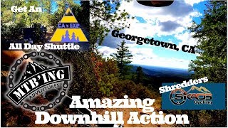
This is one of the best true DH trails in this area. Almost no pedaling required. Lots of chunk, berms, and water bars. Would not be a good trail to ride up.

Trail Supporters
  • Sponsor

  • USFS
    Land Manager
Traditionally Indigenous Territory

Recent Activity on Trail

Past Week
  • 1 rides
  • 45 miles average
6 Months
  • 4 rides
  • 45 miles avg distance
All
  • 70 rides
  • Last: Jun 14, 2026
c1c2c3c4
January
February
March
April
May
June
July
August
September
October
November
December
update trails status or condition

Trail 4-1 Trail Reports

statusdatedescription
Jun 14, 2026 @ 12:44pm (America/Los_Angeles)
Jun 14, 2026
Lots of trees down at the bottom before the bridge. And a couple trees down on the section after you cross the road.
May 30, 2026 @ 9:33am (America/Los_Angeles)
May 30, 2026
Some trees down if I remember correctly
Apr 13, 2022 @ 10:30am
Apr 13, 2022
Mar 24, 2022 @ 11:48am
Mar 24, 2022
reporter
Feb 21, 2022 @ 9:20pm
Feb 21, 2022
Rutted out glorified fire road and double track moto trail
more »
Status:
on Jun 14, 2026
Ideal
Avg: 4.11 (12 votes)
Your vote: 0

view (521)
close
3D
Trail Conditions
  • Unknown
  • Snow Groomed
  • Snow Packed
  • Snow Covered
  • Snow Cover Partial
  • Freeze/thaw Cycle
  • Icy
  • Prevalent Mud
  • Wet
  • Variable
  • Ideal
  • Dry
  • Very Dry
Trail Flow (Ridden Direction)
Trailforks scans users ridelogs to determine the most popular direction each trail is ridden. A good flowing trail network will have most trails flowing in a single direction according to their intension.
The colour categories are based on what percentage of riders are riding a trail in its intended direction.
  • > 96%
  • > 90%
  • > 80%
  • > 70%
  • > 50%
  • < 50%
  • bi-directional trail
  • no data
Trail Last Ridden
Trailforks scans ridelogs to determine the last time a trail was ridden.
  • < 2 days
  • < 1 week
  • < 2 weeks
  • < 1 month
  • < 6 months
  • > 6 months
Trail Ridden Direction
The intended direction a trail should be ridden.
  • Downhill Only
  • Downhill Primary
  • Both Directions
  • Uphill Primary
  • Uphill Only
  • One Direction
Contribute Details
Colors indicate trail is missing specified detail.
  • Description
  • Photos
  • Description & Photos
  • Videos
Trail Popularity ?
Trailforks scans ridelogs to determine which trails are ridden the most in the last 9 months. Trails are compared with nearby trails in the same city region with a possible 25 colour shades. Think of this as a heatmap, more rides = more kinetic energy = warmer colors.
  • most popular
  • popular
  • less popular
  • not popular
ATV/ORV/OHV Filter
Max Vehicle Width
inches
US Cell Coverage
Legend
cell carrier legend

Radar Time
Activity Recordings
Trailforks uses anonymized public activity data. ?
Activity Recordings
Trailforks uses anonymized public activity data. ?
Personal Heatmap
Activity Types
all / none
Options
2
Date range month
Winter Trails
Warning A routing network for winter maps does not exist. Selecting trails using the winter trails layer has been disabled.
Missing Trails
Most Popular
Least Popular
Trails are colored based on popularity. The more popular a trail is, the more red. Less popular trails trend towards green.
Jump Magnitude Heatmap
Heatmap of where riders jump on trails. Zoom in to see individual jumps, click circles to view jump details.
BC Backroad Status

Service Road Atlas is a free to use, community-driven service for viewing and creating reports on the numerous back-country service roads around B.C. and Alberta.

map legend
Slope Aspect
Direction the slope faces
Flat N NE E SE S SW W NW
Trails Deemphasized
Trails are shown in grey.
disable
Only show trails with no bike usage.
Enable
Suggested Layers
Based on selected activity type

    Save the current map location and zoom level as your default home location whenever this page is loaded.

    Save
        Directions to trail-41 trailhead (38.902170, -120.698390)

        Photos

        7 more »
        506 |
        Apr 20, 2019 @ 10:07pm
        Apr 20, 2019
        492 |
        Apr 20, 2019 @ 9:54pm
        Apr 20, 2019
        469 |
        Jul 8, 2020 @ 12:12pm
        Jul 8, 2020
        470 |
        Apr 20, 2019 @ 10:03pm
        Apr 20, 2019

        Videos

        6 more »
        youtuber Georgetown Shuttles: Pt. 2 of 3 - Rock Creek...
        11:18 | 979 | Dec 10, 2017 , Georgetown
        youtuber BUILDING MY 2019 RACE BIKE
        9:59 | 537 | Dec 19, 2018 , Georgetown
        youtuber Georgetown, CA All Day Downhill Fun - Mountain...
        12:37 | 780 | Oct 13, 2018 , Georgetown
        youtuber Georgetown (El Dorado County, CA) Mountain Biking
        12:23 | 731 | Feb 7, 2018 , Georgetown

        Routes with this trail

        3.7 13 miles 2,186 ft 7 Point to Point
        This is a classic point to point with three good DH runs. There is a Hike a Bike section in the middle....
        5.0 11 miles 2,308 ft 14 Loop
        Classic Georgetown moto trail drop with a little climbing and a mellow climb back out on a lightly used...
        5.0 8 miles 1,677 ft 19 Loop
        Mellow climbs and long no pedal dowhhill sections on loose and gnarly moto trail. Great for e-bike laps...

        1 Review & Comments


        We hope you've been enjoying Trailforks!

        Create a FREE account to view trail comments and much more.

        • By DaveySImonTF Pro & contributors
        • #57360 - 5,343 views

        Frequently Asked Questions About Trail 4-1

        Where is Trail 4-1 located?
        Trail 4-1 is located in Rock Creek, Georgetown, California, United States. It is part of the Rock Creek trail network. The trailhead is located at coordinates 38.90217, -120.69839.
        How hard is Trail 4-1?
        Trail 4-1 is rated as Black Diamond difficulty. The average grade is 11.2%.
        What is the elevation gain for Trail 4-1?
        Trail 4-1 has 27 ft of elevation gain. The trail has 1,224 ft of elevation descent. The elevation ranges from 3,219 ft to 4,421 ft.
        Is Trail 4-1 a point to point trail?
        Trail 4-1 is not a point to point trail. The direction is Downhill Primary. The trail type is singletrack.

        Hit the Trail

        Open in App

        Get this trail on your phone instantly.
        open trail in app

        Download Trail

        Save to wishlist, Garmin & download.
        save the trail

        Find Related Routes

        Find routes and users activities that include this trail.
        find routes for this trail

        You must enter a description before submitting.