more stats
3.8 miles
Distance
490 ft
Climb
-539 ft
Descent
00:26:33
Avg time
-51 ft
Altitude change
499 ft
Altitude min
937 ft
Altitude max
853 ft
Altitude start
801 ft
Altitude end
-0.3%
Grade
-42%
Grade max
30.2%
Grade min
2 miles
Distance climb
2 miles
Distance down
1,509 ft
Distance flat
00:26:33
Avg time

Trail 47 Details

  • Activities
    • Mountain Bike
    • E-Bike
    • Adaptive Bike
    • Horse
    • Hike
    • Trail Running
  • Riding Area
    Fort Ord National Monument
    Monterey, California
  • AKA
    Couch Canyon
  • Difficulty Rating
  • Local Popularity
    30 in Mountain Biking [+]
    • 45 in E-Biking
    • 60 in Trail Running
    • 40 in Hiking
    • 5 in Horseback
  • Global Ranking
    #109352 in Mountain Biking [+]
    • #80538 in E-Biking
    • #91152 in Trail Running
    • #111603 in Hiking
    • #1407 in Horseback
  • Trail Type
    Mixed
  • Bike Type
    AM, XC, Adaptive MTB
  • Direction
    Both Directions
  • Climb Difficulty
    Blue
  • Physical Rating
    Hard
  • Season
    All year
  • Dogs Allowed
    Yes
  • eBike Allowed
    Yes up to Class 1
  • Land Owner

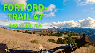
CYCLIST NOTES: Starting from Skyline Road, climb up the hill toward Laguna Seca and look for the trail to split off to your left. The initial descent behind turn 6 of Laguna Seca Raceway is fun and flows well. After the descent, climb a bit and pass the entrance/exit to the Grand Prix Campground and then start a long descent down the hillside through the Fort Ord Grasslands. Look for a split in the trail. Straight ahead is Trail 47 which re-connects with Trail 48 after a short distance.

For a little longer ride some nice views and a drop further down the hill take Trail 48 to the right. After another climb, follow the trail around a hill and then drop down into the bottom of Couch Canyon. After crossing a dry stream bed gradually climb up and out toward Skyline Road. Before you get there face "Hurl Hill" for a possible hike-a-bike.

NATIONAL MONUMENT NOTES:
This BLM managed trail is open from dawn to dusk to cyclists, hikers/joggers, and equestrians. The trail is two-way directional, and cyclists must yield to all other users; hikers/joggers must yield to equestrians. Maximum passing speed limit is less than 5 mph for cyclists for oncoming trail users and when passing those that have slowed/stopped and moved to edge of trail. Please leash your pet.

Access Info

Access via Skyline Rd heading South OR Guidotti Rd heading South

Adaptive Bike Info
aMTB Green Rating: Beginner features and moderate terrain.

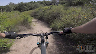
Some slight off-camber, but most adaptive riders will be good

Trail Supporters
  • BLM
    BLM
    Land Manager
Local Trail Association
Traditionally Indigenous Territory

Recent Activity on Trail

Past Week
  • 2 rides
  • 24 miles average
6 Months
  • 14 rides
  • 28 miles avg distance
All
  • 129 rides
  • Last: Jun 22, 2026
c1c2c3c4
January
February
March
April
May
June
July
August
September
October
November
December
update trails status or condition

Trail 47 Trail Reports

statusdatedescription
Mar 28, 2025 @ 9:55am
Mar 28, 2025
There is some tall grass next to some of the narrow trails. It is a fun route.
May 29, 2024 @ 3:08pm
May 29, 2024
Getting pretty over grown and hard to pass through.
Feb 23, 2024 @ 10:27am
Feb 23, 2024
Very muddy in several spots. Probably best to avoid for a couple weeks and let it dry up
Sep 22, 2023 @ 8:42am
Sep 22, 2023
Half of the trail has been cleared. Still some overgrown parts. The bridge at the bottom is coming along nicely.
Jun 19, 2023 @ 10:54pm
Jun 19, 2023
Don’t ride here, the trail is super overgrown and the only rideable part is the start, don’t go here
more »
Status:
on Mar 28, 2025
Dry
Avg: 4.06 (10 votes)
Your vote: 0

view (1,372)
close
3D
Trail Conditions
  • Unknown
  • Snow Groomed
  • Snow Packed
  • Snow Covered
  • Snow Cover Partial
  • Freeze/thaw Cycle
  • Icy
  • Prevalent Mud
  • Wet
  • Variable
  • Ideal
  • Dry
  • Very Dry
Trail Flow (Ridden Direction)
Trailforks scans users ridelogs to determine the most popular direction each trail is ridden. A good flowing trail network will have most trails flowing in a single direction according to their intension.
The colour categories are based on what percentage of riders are riding a trail in its intended direction.
  • > 96%
  • > 90%
  • > 80%
  • > 70%
  • > 50%
  • < 50%
  • bi-directional trail
  • no data
Trail Last Ridden
Trailforks scans ridelogs to determine the last time a trail was ridden.
  • < 2 days
  • < 1 week
  • < 2 weeks
  • < 1 month
  • < 6 months
  • > 6 months
Trail Ridden Direction
The intended direction a trail should be ridden.
  • Downhill Only
  • Downhill Primary
  • Both Directions
  • Uphill Primary
  • Uphill Only
  • One Direction
Contribute Details
Colors indicate trail is missing specified detail.
  • Description
  • Photos
  • Description & Photos
  • Videos
Trail Popularity ?
Trailforks scans ridelogs to determine which trails are ridden the most in the last 9 months. Trails are compared with nearby trails in the same city region with a possible 25 colour shades. Think of this as a heatmap, more rides = more kinetic energy = warmer colors.
  • most popular
  • popular
  • less popular
  • not popular
ATV/ORV/OHV Filter
Max Vehicle Width
inches
US Cell Coverage
Legend
cell carrier legend

Radar Time
Activity Recordings
Trailforks uses anonymized public activity data. ?
Activity Recordings
Trailforks uses anonymized public activity data. ?
Personal Heatmap
Activity Types
all / none
Options
2
Date range month
Winter Trails
Warning A routing network for winter maps does not exist. Selecting trails using the winter trails layer has been disabled.
Missing Trails
Most Popular
Least Popular
Trails are colored based on popularity. The more popular a trail is, the more red. Less popular trails trend towards green.
Jump Magnitude Heatmap
Heatmap of where riders jump on trails. Zoom in to see individual jumps, click circles to view jump details.
BC Backroad Status

Service Road Atlas is a free to use, community-driven service for viewing and creating reports on the numerous back-country service roads around B.C. and Alberta.

map legend
Slope Aspect
Direction the slope faces
Flat N NE E SE S SW W NW
Trails Deemphasized
Trails are shown in grey.
disable
Only show trails with no bike usage.
Enable
Suggested Layers
Based on selected activity type

    Save the current map location and zoom level as your default home location whenever this page is loaded.

    Save
        Directions to trail-47 trailhead (36.589650, -121.743050)

        Photos

        17 more »
        95 |
        Oct 27, 2023 @ 9:24pm
        Oct 27, 2023
        91 |
        Oct 27, 2023 @ 9:24pm
        Oct 27, 2023
        122 |
        Sep 26, 2021 @ 7:11pm
        Sep 26, 2021
        134 |
        Sep 26, 2021 @ 7:11pm
        Sep 26, 2021

        Videos

        3 more »
        UNCUT Trail 47 - Adaptive MTB - Fort Ord -...
        5:07 | 349 | May 23, 2022 , Monterey
        Mountain Biking Fort Ord - Trail 47 | Salinas, CA
        5:19 | 452 | Jan 9, 2022 , Monterey
        Trail 47 Highlights
        5:25 | 500 | May 29, 2019 , Monterey

        Routes with this trail

        20 miles 2,709 ft 19 Loop
        This is a route that I like to do when starting from Creekside Terrace.
        16 miles 2,270 ft 7
        Inside Trail 25K Loop (Orange, Purple, and Orange)
        5.0 19 miles 2,665 ft 22 Loop Race
        Cat 2/3 course for Sea Otter Classic XC 2018

        5 Reviews & Comments


        We hope you've been enjoying Trailforks!

        Create a FREE account to view trail comments and much more.

        Frequently Asked Questions About Trail 47

        Where is Trail 47 located?
        Trail 47 is located in Fort Ord National Monument, Monterey, California, United States. It is part of the Fort Ord National Monument trail network. The trailhead is located at coordinates 36.58965, -121.74305.
        How hard is Trail 47?
        Trail 47 is rated as Blue difficulty. The physical rating is Hard. The average grade is 0.3%. The climb difficulty is rated Blue.
        What is the elevation gain for Trail 47?
        Trail 47 has 490 ft of elevation gain. The trail has 539 ft of elevation descent. The elevation ranges from 499 ft to 937 ft.
        Is Trail 47 a point to point trail?
        Trail 47 is not a point to point trail. The direction is Both Directions. The trail type is mixed.

        Hit the Trail

        Open in App

        Get this trail on your phone instantly.
        open trail in app

        Download Trail

        Save to wishlist, Garmin & download.
        save the trail

        Find Related Routes

        Find routes and users activities that include this trail.
        find routes for this trail

        You must enter a description before submitting.