more stats
1.3 miles
Distance
3 ft
Climb
-751 ft
Descent
00:02:16
Avg time
-748 ft
Altitude change
3,654 ft
Altitude min
4,402 ft
Altitude max
4,402 ft
Altitude start
3,655 ft
Altitude end
-10.8%
Grade
-53.4%
Grade max
3.1%
Grade min
128 ft
Distance climb
1 mile
Distance down
62 ft
Distance flat
00:02:16
Avg time

Trail Dogs Details

  • Activities
    • Mountain Bike
    • E-Bike
    • Adaptive Bike
    • Winter Fat Bike
  • Riding Area
    Fernie
    , British Columbia
  • Difficulty Rating
  • Voted Difficulty
    Blue (1 vote)
  • Local Popularity
    95 in Mountain Biking [+]
    • 100 in E-Biking
  • Global Ranking
    #613 in Mountain Biking [+]
    • #2212 in E-Biking
  • Trail Type
    Machine Groomed
  • Bike Type
    DH, AM, XC, DJ, Fat, Adaptive MTB
  • Direction
    Downhill Only
    Popular Direction Shown
  • Trail Visibility
    Always easy to follow
  • Dogs Allowed
    Yes
  • eBike Allowed
    Yes up to Class 1
  • TTFs on Trail
    Berm, Jump
  • Year Opened
    2021

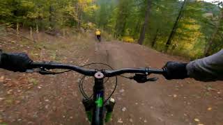
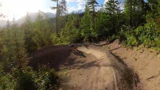
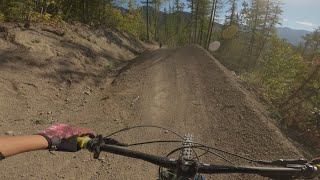
Trail Dogs is a blue flow trail with jumps, berms, rollers and more. It is a ton of fun for all riders This is an easier option to Contra but still be sure to do an initial Pre-ride and Re-ride before you Free-ride / send it.

The portion below Contra opened in 2021 and in 2024 the upper portion paralleling Contra was completed. It can be ridden from the top or accessed from the switchback in the road at the bottom of Contra.

The trail was named in honour of Pippa, and all the good dogs who get excited when you put your helmet on, who shred harder than us, and whose love and joy make every ride special. We love you trail dogs.

Access Info

For self propelled access take Up Dog from the bottom. You can get onto Trail Dogs 1/3 of the way up where Contra ends or continue to the very top. It is possible to shuttle but the road is steep and rough with very limited space to turn around at the top. Please don't leave a vehicle parked at the top as there just isn't much space.

Local Trail Association
Traditionally Indigenous Territory

Recent Activity on Trail

Past Week
  • 14 rides
  • 8 miles average
6 Months
  • 144 rides
  • 12 miles avg distance
All
  • 880 rides
  • Last: Jun 25, 2026
c1c2c3c4
January
February
March
April
May
June
July
August
September
October
November
December
update trails status or condition

Trail Dogs Trail Reports

statusdatedescription
May 18, 2026 @ 9:41am (America/Creston)
May 18, 2026
reporter
May 8, 2026 @ 9:12am (America/Creston)
May 8, 2026
reporter Trail was fully raked on FTA dig night May 7
Apr 28, 2026 @ 8:03pm (America/Edmonton)
Apr 28, 2026
Apr 21, 2026 @ 6:51pm (America/Edmonton)
Apr 21, 2026
reporter Upper Trail Dogs is open again. We fixed the jump where there was a slump and unsafe landing. There is still water seeping from the left bank...
Apr 19, 2026 @ 12:50pm (America/Edmonton)
Apr 19, 2026
reporter Trail Dogs and Contra remain closed at the top due to erosion issues on some landings that are a safety concern. They are both open from a mid...
more »
Status:
on May 18, 2026
Ideal
Avg: 4.62 (15 votes)
Your vote: 0

view (6,048)
close
3D
Trail Conditions
  • Unknown
  • Snow Groomed
  • Snow Packed
  • Snow Covered
  • Snow Cover Partial
  • Freeze/thaw Cycle
  • Icy
  • Prevalent Mud
  • Wet
  • Variable
  • Ideal
  • Dry
  • Very Dry
Trail Flow (Ridden Direction)
Trailforks scans users ridelogs to determine the most popular direction each trail is ridden. A good flowing trail network will have most trails flowing in a single direction according to their intension.
The colour categories are based on what percentage of riders are riding a trail in its intended direction.
  • > 96%
  • > 90%
  • > 80%
  • > 70%
  • > 50%
  • < 50%
  • bi-directional trail
  • no data
Trail Last Ridden
Trailforks scans ridelogs to determine the last time a trail was ridden.
  • < 2 days
  • < 1 week
  • < 2 weeks
  • < 1 month
  • < 6 months
  • > 6 months
Trail Ridden Direction
The intended direction a trail should be ridden.
  • Downhill Only
  • Downhill Primary
  • Both Directions
  • Uphill Primary
  • Uphill Only
  • One Direction
Contribute Details
Colors indicate trail is missing specified detail.
  • Description
  • Photos
  • Description & Photos
  • Videos
Trail Popularity ?
Trailforks scans ridelogs to determine which trails are ridden the most in the last 9 months. Trails are compared with nearby trails in the same city region with a possible 25 colour shades. Think of this as a heatmap, more rides = more kinetic energy = warmer colors.
  • most popular
  • popular
  • less popular
  • not popular
ATV/ORV/OHV Filter
Max Vehicle Width
inches
US Cell Coverage
Legend
cell carrier legend

Radar Time
Activity Recordings
Trailforks uses anonymized public activity data. ?
Activity Recordings
Trailforks uses anonymized public activity data. ?
Personal Heatmap
Activity Types
all / none
Options
2
Date range month
Winter Trails
Warning A routing network for winter maps does not exist. Selecting trails using the winter trails layer has been disabled.
Missing Trails
Most Popular
Least Popular
Trails are colored based on popularity. The more popular a trail is, the more red. Less popular trails trend towards green.
Jump Magnitude Heatmap
Heatmap of where riders jump on trails. Zoom in to see individual jumps, click circles to view jump details.
BC Backroad Status

Service Road Atlas is a free to use, community-driven service for viewing and creating reports on the numerous back-country service roads around B.C. and Alberta.

map legend
Slope Aspect
Direction the slope faces
Flat N NE E SE S SW W NW
Trails Deemphasized
Trails are shown in grey.
disable
Only show trails with no bike usage.
Enable
Suggested Layers
Based on selected activity type

    Save the current map location and zoom level as your default home location whenever this page is loaded.

    Save
        Directions to trail-dogs trailhead (49.507700, -115.020660)

        Photos

        25 more »
        80 |
        Oct 16, 2024 @ 1:34pm
        Oct 16, 2024
        81 |
        Oct 8, 2024 @ 6:52am
        Oct 8, 2024
        91 |
        Oct 8, 2024 @ 6:52am
        Oct 8, 2024
        77 |
        Oct 8, 2024 @ 6:52am
        Oct 8, 2024

        Videos

        4 more »
        youtuber Fernie's BEST New Trail! 6 More Days and Trail...
        281 | May 25, 2025 , Fernie
        Contra to Traildog, local trails in Fernie, BC
        8:38 | 342 | Dec 30, 2023 , Fernie
        Contra - Trail Dogs
        6:29 | 749 | Jul 28, 2022 , Fernie
        Trail Dogs (Fernie)
        0:21 | 547 | Oct 22, 2021 , Fernie

        Routes with this trail

        7 miles 1,115 ft 10
        easy climb through ridgemont with downhill on contra. loop back on heritage trail at end

        6 Reviews & Comments


        We hope you've been enjoying Trailforks!

        Create a FREE account to view trail comments and much more.

        • By Dannyzm1TF Pro & contributors
        • #439884 - 6,014 views

        Frequently Asked Questions About Trail Dogs

        Where is Trail Dogs located?
        Trail Dogs is located in Fernie, British Columbia, Canada. It is part of the Fernie trail network. The trailhead is located at coordinates 49.5077, -115.02066.
        How hard is Trail Dogs?
        Trail Dogs is rated as Blue difficulty. The average grade is 10.8%.
        What is the elevation gain for Trail Dogs?
        Trail Dogs has 3 ft of elevation gain. The trail has 751 ft of elevation descent. The elevation ranges from 3,654 ft to 4,402 ft.
        Is Trail Dogs a point to point trail?
        Yes, Trail Dogs is a point to point trail. The direction is Downhill Only. The trail type is machine groomed.

        Hit the Trail

        Open in App

        Get this trail on your phone instantly.
        open trail in app

        Download Trail

        Save to wishlist, Garmin & download.
        save the trail

        Find Related Routes

        Find routes and users activities that include this trail.
        find routes for this trail

        You must enter a description before submitting.