more stats
1.5 miles
Distance
330 ft
Climb
-40 ft
Descent
00:19:40
Avg time
290 ft
Altitude change
5,770 ft
Altitude min
6,062 ft
Altitude max
5,770 ft
Altitude start
6,060 ft
Altitude end
3.8%
Grade
-9.9%
Grade max
20.2%
Grade min
5,030 ft
Distance climb
1,650 ft
Distance down
1,017 ft
Distance flat
00:19:40
Avg time

Traildemic Details

  • Activities
    • Mountain Bike
    • E-Bike
    • Winter Fat Bike
    • Hike
    • Trail Running
  • Riding Area
    North Fork Park
    Eden, Utah
  • Difficulty Rating
  • Local Popularity
    90 in Mountain Biking [+]
    • 85 in E-Biking
    • 5 in Trail Running
    • 75 in Hiking
  • Global Ranking
    #8346 in Mountain Biking [+]
    • #38053 in E-Biking
    • #109638 in Trail Running
    • #56170 in Hiking
  • Hiking SAC Scale
    T1 Hiking
  • Trail Type
    Singletrack
  • Bike Type
    XC
  • Direction
    Both Directions
  • Season
    3.5
  • Dogs Allowed
    Yes
  • eBike Allowed
  • Year Opened
    2020
  • Land Owner
    Weber County

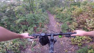
Traildemic was added to North Fork Park by Trails Foundation of Northern Utah. It's a fun ride/hike through trees and parallels Cutler Creek towards the bottom. Look for the hidden alternate lines if you want a challenge.

Trail Supporters

  • Trails Foundation of Northern Utah
    Sponsor
Local Trail Association
Traditionally Indigenous Territory

Recent Activity on Trail

Past Week
  • 5 rides
  • 10 miles average
6 Months
  • 43 rides
  • 12 miles avg distance
All
  • 648 rides
  • Last: Jun 21, 2026
c1c2c3c4
January
February
March
April
May
June
July
August
September
October
November
December
update trails status or condition

Traildemic Trail Reports

Status:
on May 21, 2026
Dry
Avg: 4.19 (4 votes)
Your vote: 0

view (2,594)
close
3D
Trail Conditions
  • Unknown
  • Snow Groomed
  • Snow Packed
  • Snow Covered
  • Snow Cover Partial
  • Freeze/thaw Cycle
  • Icy
  • Prevalent Mud
  • Wet
  • Variable
  • Ideal
  • Dry
  • Very Dry
Trail Flow (Ridden Direction)
Trailforks scans users ridelogs to determine the most popular direction each trail is ridden. A good flowing trail network will have most trails flowing in a single direction according to their intension.
The colour categories are based on what percentage of riders are riding a trail in its intended direction.
  • > 96%
  • > 90%
  • > 80%
  • > 70%
  • > 50%
  • < 50%
  • bi-directional trail
  • no data
Trail Last Ridden
Trailforks scans ridelogs to determine the last time a trail was ridden.
  • < 2 days
  • < 1 week
  • < 2 weeks
  • < 1 month
  • < 6 months
  • > 6 months
Trail Ridden Direction
The intended direction a trail should be ridden.
  • Downhill Only
  • Downhill Primary
  • Both Directions
  • Uphill Primary
  • Uphill Only
  • One Direction
Contribute Details
Colors indicate trail is missing specified detail.
  • Description
  • Photos
  • Description & Photos
  • Videos
Trail Popularity ?
Trailforks scans ridelogs to determine which trails are ridden the most in the last 9 months. Trails are compared with nearby trails in the same city region with a possible 25 colour shades. Think of this as a heatmap, more rides = more kinetic energy = warmer colors.
  • most popular
  • popular
  • less popular
  • not popular
ATV/ORV/OHV Filter
Max Vehicle Width
inches
US Cell Coverage
Legend
cell carrier legend

Radar Time
Activity Recordings
Trailforks uses anonymized public activity data. ?
Activity Recordings
Trailforks uses anonymized public activity data. ?
Personal Heatmap
Activity Types
all / none
Options
2
Date range month
Winter Trails
Warning A routing network for winter maps does not exist. Selecting trails using the winter trails layer has been disabled.
Missing Trails
Most Popular
Least Popular
Trails are colored based on popularity. The more popular a trail is, the more red. Less popular trails trend towards green.
Jump Magnitude Heatmap
Heatmap of where riders jump on trails. Zoom in to see individual jumps, click circles to view jump details.
BC Backroad Status

Service Road Atlas is a free to use, community-driven service for viewing and creating reports on the numerous back-country service roads around B.C. and Alberta.

map legend
Slope Aspect
Direction the slope faces
Flat N NE E SE S SW W NW
Trails Deemphasized
Trails are shown in grey.
disable
Only show trails with no bike usage.
Enable
Suggested Layers
Based on selected activity type

    Save the current map location and zoom level as your default home location whenever this page is loaded.

    Save
        Directions to traildemic trailhead (41.387560, -111.913030)

        Photos

        5 more »
        86 |
        Sep 18, 2021 @ 6:53pm
        Sep 18, 2021
        62 |
        Sep 23, 2022 @ 4:20pm
        Sep 23, 2022
        80 |
        Sep 6, 2021 @ 6:36pm
        Sep 6, 2021
        82 |
        Sep 6, 2021 @ 6:36pm
        Sep 6, 2021

        Videos

        1 more »
        Mountain Biking at North Fork Park, UT
        10:22 | 699 | Sep 9, 2021 , Eden

        Routes with this trail

        11 miles 1,647 ft 2
        Have a great night riding
        7 miles 1,013 ft 4
        NUT Festival Trails Foundation of Northern Utah 2022
        1.0 12 miles 2,065 ft 6
        North Fork Loop route through 365, Mule Ear, and Bicen and Cutler Twist. 12 miles.

        Reviews / Comments

        No reviews yet, be the first to write a review or ask a question.
        Use trail reports to comment on trail conditions.


        We hope you've been enjoying Trailforks!

        Create a FREE account to view trail comments and much more.

        • By Nalaw1TF Pro EVT & contributors
        • #441727 - 1,666 views

        Frequently Asked Questions About Traildemic

        Where is Traildemic located?
        Traildemic is located in North Fork Park, Eden, Utah, United States. It is part of the North Fork Park trail network. The trailhead is located at coordinates 41.38756, -111.91303.
        How hard is Traildemic?
        Traildemic is rated as Green difficulty. The average grade is 3.8%.
        What is the elevation gain for Traildemic?
        Traildemic has 330 ft of elevation gain. The trail has 40 ft of elevation descent. The elevation ranges from 5,770 ft to 6,062 ft.
        Is Traildemic a point to point trail?
        Traildemic is not a point to point trail. The direction is Both Directions. The trail type is singletrack.

        Hit the Trail

        Open in App

        Get this trail on your phone instantly.
        open trail in app

        Download Trail

        Save to wishlist, Garmin & download.
        save the trail

        Find Related Routes

        Find routes and users activities that include this trail.
        find routes for this trail

        You must enter a description before submitting.