more stats
636 ft
Distance
-39 ft
Descent
00:02:36
Avg time
-39 ft
Altitude change
463 ft
Altitude min
502 ft
Altitude max
502 ft
Altitude start
463 ft
Altitude end
-6.2%
Grade
-20.9%
Grade max
407 ft
Distance down
230 ft
Distance flat
00:02:36
Avg time

Transfer Line Details

  • Activities
    • Mountain Bike
    • E-Bike
    • Winter Fat Bike
    • Hike
    • Trail Running
  • Riding Area
    Woburn Bike Park
    Aspley Heath
  • Difficulty Rating
  • Local Popularity
    35 in Mountain Biking [+]
    • 95 in E-Biking
    • 50 in Trail Running
    • 100 in Hiking
  • Global Ranking
    #24257 in Mountain Biking [+]
    • #5494 in E-Biking
    • #98512 in Trail Running
    • #21998 in Hiking
  • Trail Type
    Singletrack
  • Bike Type
    DH, AM, XC, DJ, Fat
  • Direction
    Downhill Primary
  • Dogs Allowed
    Yes
  • eBike Allowed
    Yes up to Class 1
  • TTFs on Trail
    Berm, Jump, Gap Jump
  • Land Owner
    Greensands Trust

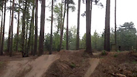
Nice big berms to hook into, jumps and a gap jump near the end that can be ridden around if needed.

Access Info

A pass is required to ride - Day & Annual passes available - covers both the Bike Park & XC trails https://www.greensandtrust.org/Event/aspley-bike-pass

Recent Activity on Trail

Past Week
  • 0 rides
  •  
6 Months
  • 1 rides
  • 11 miles avg distance
All
  • 91 rides
  • Last: May 29, 2026
c1c2c3c4
January
February
March
April
May
June
July
August
September
October
November
December
update trails status or condition

Transfer Line Trail Reports

Status:
on Jan 25, 2025
Ideal
Avg: 4.32 (3 votes)
Your vote: 0

view (9,200)
close
3D
Trail Conditions
  • Unknown
  • Snow Groomed
  • Snow Packed
  • Snow Covered
  • Snow Cover Partial
  • Freeze/thaw Cycle
  • Icy
  • Prevalent Mud
  • Wet
  • Variable
  • Ideal
  • Dry
  • Very Dry
Trail Flow (Ridden Direction)
Trailforks scans users ridelogs to determine the most popular direction each trail is ridden. A good flowing trail network will have most trails flowing in a single direction according to their intension.
The colour categories are based on what percentage of riders are riding a trail in its intended direction.
  • > 96%
  • > 90%
  • > 80%
  • > 70%
  • > 50%
  • < 50%
  • bi-directional trail
  • no data
Trail Last Ridden
Trailforks scans ridelogs to determine the last time a trail was ridden.
  • < 2 days
  • < 1 week
  • < 2 weeks
  • < 1 month
  • < 6 months
  • > 6 months
Trail Ridden Direction
The intended direction a trail should be ridden.
  • Downhill Only
  • Downhill Primary
  • Both Directions
  • Uphill Primary
  • Uphill Only
  • One Direction
Contribute Details
Colors indicate trail is missing specified detail.
  • Description
  • Photos
  • Description & Photos
  • Videos
Trail Popularity ?
Trailforks scans ridelogs to determine which trails are ridden the most in the last 9 months. Trails are compared with nearby trails in the same city region with a possible 25 colour shades. Think of this as a heatmap, more rides = more kinetic energy = warmer colors.
  • most popular
  • popular
  • less popular
  • not popular
ATV/ORV/OHV Filter
Max Vehicle Width
inches
US Cell Coverage
Legend
cell carrier legend

Radar Time
Activity Recordings
Trailforks uses anonymized public activity data. ?
Activity Recordings
Trailforks uses anonymized public activity data. ?
Personal Heatmap
Activity Types
all / none
Options
2
Date range month
Winter Trails
Warning A routing network for winter maps does not exist. Selecting trails using the winter trails layer has been disabled.
Missing Trails
Most Popular
Least Popular
Trails are colored based on popularity. The more popular a trail is, the more red. Less popular trails trend towards green.
Jump Magnitude Heatmap
Heatmap of where riders jump on trails. Zoom in to see individual jumps, click circles to view jump details.
BC Backroad Status

Service Road Atlas is a free to use, community-driven service for viewing and creating reports on the numerous back-country service roads around B.C. and Alberta.

map legend
Slope Aspect
Direction the slope faces
Flat N NE E SE S SW W NW
Trails Deemphasized
Trails are shown in grey.
disable
Only show trails with no bike usage.
Enable
Suggested Layers
Based on selected activity type

    Save the current map location and zoom level as your default home location whenever this page is loaded.

    Save
        Directions to transfer-line trailhead (52.004630, -0.646120)

        Photos

        76 more »
        78 |
        Apr 4, 2024 @ 8:55am
        Apr 4, 2024
        218 |
        Dec 11, 2021 @ 10:46am
        Dec 11, 2021
        664 |
        Dec 10, 2017 @ 9:26am
        Dec 10, 2017
        75 |
        Jan 4, 2010 @ 3:08pm
        Jan 4, 2010

        Videos

        17 more »
        Woburn Sands Bike Park, transition line
        769 | Nov 30, 2015 , Aspley Heath
        Messing about at Woburn
        0:04 | 376 | May 5, 2015 , Aspley Heath
        Following Will down Transfer
        0:36 | 147 | Sep 10, 2013 , Aspley Heath
        woburn sands
        0:06 | 865 | Oct 15, 2012 , Aspley Heath

        Reviews / Comments

        No reviews yet, be the first to write a review or ask a question.
        Use trail reports to comment on trail conditions.


        We hope you've been enjoying Trailforks!

        Create a FREE account to view trail comments and much more.

        • By PabloGTTF Pro & contributors
        • #76926 - 3,764 views

        Frequently Asked Questions About Transfer Line

        Where is Transfer Line located?
        Transfer Line is located in Woburn Bike Park, Aspley Heath, United Kingdom. It is part of the Woburn Bike Park trail network. The trailhead is located at coordinates 52.00463, -0.64612.
        How hard is Transfer Line?
        Transfer Line is rated as Red difficulty. The average grade is 6.2%.
        What is the elevation gain for Transfer Line?
        The trail has 12 m of elevation descent. The elevation ranges from 141 m to 153 m.
        Is Transfer Line a point to point trail?
        Transfer Line is not a point to point trail. The direction is Downhill Primary. The trail type is singletrack.

        Hit the Trail

        Open in App

        Get this trail on your phone instantly.
        open trail in app

        Download Trail

        Save to wishlist, Garmin & download.
        save the trail

        Find Related Routes

        Find routes and users activities that include this trail.
        find routes for this trail

        You must enter a description before submitting.