more stats
4,455 ft
Distance
-622 ft
Descent
00:19:57
Avg time
-622 ft
Altitude change
2,374 ft
Altitude min
2,995 ft
Altitude max
2,995 ft
Altitude start
2,375 ft
Altitude end
-14%
Grade
-46.5%
Grade max
-1.1%
Grade min
4,455 ft
Distance down
00:19:57
Avg time

Trdinka Details

  • Activities
    • Mountain Bike
    • Winter Fat Bike
  • Riding Area
    Gorjanci
    Novo mesto
  • Difficulty Rating
  • Voted Difficulty
    Double Black Diamond (3 votes)
  • Local Popularity
    85 in Mountain Biking
  • Global Ranking
    #59402 in Mountain Biking
  • Trail Type
    Singletrack
  • Bike Type
    DH, AM, Fat
  • Direction
    Downhill Only
    Popular Direction Shown
  • Physical Rating
    Hard
  • Trail Visibility
    Sometimes hard to follow
  • Season
    April - October
  • Dogs Allowed
    Yes
  • eBike Allowed
    Yes up to Class 1
  • TTFs on Trail
    Berm, Jump
  • Year Opened
    2019

No community description for Trdinka trail has been added yet!

AI Generated Description

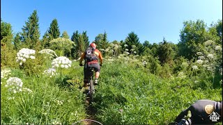
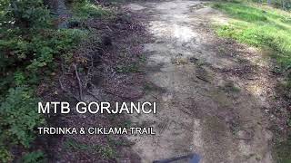
Trdinka is a 1 km popular black difficulty singletrack trail located near Novo mesto. This mountain bike primary trail can be used downhill only and has a hard overall physical rating. It features berm and jump. Trail visibility is sometimes hard to follow. On average it takes 19 minutes to complete this trail.

Access Info

Malo naprej od križišča za Trdinov vrh je odcep planinske poti za Gospodično. Dva metra pred planinsko oznako zaviješ desno v strmino. Je vidna prva banda in traila ni več težko slediti.

Recent Activity on Trail

Past Week
  • 0 rides
  •  
6 Months
  • 5 rides
  • 11 miles avg distance
All
  • 65 rides
  • Last: Apr 13, 2026
c1c2c3c4
January
February
March
April
May
June
July
August
September
October
November
December
update trails status or condition

Trdinka Trail Reports

statusdatedescription
Aug 18, 2024 @ 10:07am
Aug 18, 2024
All good, running great!
Jun 22, 2024 @ 4:48am
Jun 22, 2024
Apr 8, 2023 @ 5:58am
Apr 8, 2023
timber on trail for about 50m of the trail. you have to carry bike over the logs.
Jun 4, 2022 @ 11:51am
Jun 4, 2022
Na nekaterih mestih drseče, tudi nekaj mest z blatom. Drugače brez težav, gre razmeroma tekoče.
Apr 17, 2022 @ 2:13am
Apr 17, 2022
Leaves on few details, but excellent conditions and trail
more »
Status:
on Aug 18, 2024
Dry
Avg: 4.17 (5 votes)
Your vote: 0

view (326)
close
3D
Trail Conditions
  • Unknown
  • Snow Groomed
  • Snow Packed
  • Snow Covered
  • Snow Cover Partial
  • Freeze/thaw Cycle
  • Icy
  • Prevalent Mud
  • Wet
  • Variable
  • Ideal
  • Dry
  • Very Dry
Trail Flow (Ridden Direction)
Trailforks scans users ridelogs to determine the most popular direction each trail is ridden. A good flowing trail network will have most trails flowing in a single direction according to their intension.
The colour categories are based on what percentage of riders are riding a trail in its intended direction.
  • > 96%
  • > 90%
  • > 80%
  • > 70%
  • > 50%
  • < 50%
  • bi-directional trail
  • no data
Trail Last Ridden
Trailforks scans ridelogs to determine the last time a trail was ridden.
  • < 2 days
  • < 1 week
  • < 2 weeks
  • < 1 month
  • < 6 months
  • > 6 months
Trail Ridden Direction
The intended direction a trail should be ridden.
  • Downhill Only
  • Downhill Primary
  • Both Directions
  • Uphill Primary
  • Uphill Only
  • One Direction
Contribute Details
Colors indicate trail is missing specified detail.
  • Description
  • Photos
  • Description & Photos
  • Videos
Trail Popularity ?
Trailforks scans ridelogs to determine which trails are ridden the most in the last 9 months. Trails are compared with nearby trails in the same city region with a possible 25 colour shades. Think of this as a heatmap, more rides = more kinetic energy = warmer colors.
  • most popular
  • popular
  • less popular
  • not popular
ATV/ORV/OHV Filter
Max Vehicle Width
inches
US Cell Coverage
Legend
cell carrier legend

Radar Time
Activity Recordings
Trailforks uses anonymized public activity data. ?
Activity Recordings
Trailforks uses anonymized public activity data. ?
Personal Heatmap
Activity Types
all / none
Options
2
Date range month
Winter Trails
Warning A routing network for winter maps does not exist. Selecting trails using the winter trails layer has been disabled.
Missing Trails
Most Popular
Least Popular
Trails are colored based on popularity. The more popular a trail is, the more red. Less popular trails trend towards green.
Jump Magnitude Heatmap
Heatmap of where riders jump on trails. Zoom in to see individual jumps, click circles to view jump details.
BC Backroad Status

Service Road Atlas is a free to use, community-driven service for viewing and creating reports on the numerous back-country service roads around B.C. and Alberta.

map legend
Slope Aspect
Direction the slope faces
Flat N NE E SE S SW W NW
Trails Deemphasized
Trails are shown in grey.
disable
Only show trails with no bike usage.
Enable
Suggested Layers
Based on selected activity type

    Save the current map location and zoom level as your default home location whenever this page is loaded.

    Save
        Directions to trdinka trailhead (45.768440, 15.309230)

        Photos

        52 more »
        100 |
        Jun 27, 2024 @ 6:58am
        Jun 27, 2024
        87 |
        Jun 27, 2024 @ 6:58am
        Jun 27, 2024
        197 |
        Jun 27, 2024 @ 6:58am
        Jun 27, 2024
        101 |
        Jun 27, 2024 @ 6:58am
        Jun 27, 2024

        Videos

        4 more »
        Sveta Gera/Trdinov vrh: Trdinka + Ciklama +...
        13:37 | 791 | Jul 12, 2021 , Novo mesto
        Še preden se je Trdinki reklu Trdinka
        3:36 | 424 | Sep 19, 2020 , Novo mesto
        Nedeljsko lagano po teh stezicah
        7:00 | 541 | Sep 19, 2020 , Novo mesto
        SloEnduro Gorjanci 2023
        2:14 | 162 | Sep 5, 2023 , Novo mesto

        5 Reviews & Comments


        We hope you've been enjoying Trailforks!

        Create a FREE account to view trail comments and much more.

        • By Marczver & contributors
        • #204525 - 2,933 views

        Frequently Asked Questions About Trdinka

        Where is Trdinka located?
        Trdinka is located in Gorjanci, Novo mesto, Slovenia. It is part of the Gorjanci trail network. The trailhead is located at coordinates 45.76844, 15.30923.
        How hard is Trdinka?
        Trdinka is rated as Black difficulty. The physical rating is Hard. The average grade is 14%.
        What is the elevation gain for Trdinka?
        The trail has 190 m of elevation descent. The elevation ranges from 724 m to 913 m.
        Is Trdinka a point to point trail?
        Yes, Trdinka is a point to point trail. The direction is Downhill Only. The trail type is singletrack.

        Hit the Trail

        Open in App

        Get this trail on your phone instantly.
        open trail in app

        Download Trail

        Save to wishlist, Garmin & download.
        save the trail

        Find Related Routes

        Find routes and users activities that include this trail.
        find routes for this trail

        You must enter a description before submitting.