more stats
3,701 ft
Distance
129 ft
Climb
-501 ft
Descent
00:40:58
Avg time
-372 ft
Altitude change
870 ft
Altitude min
1,326 ft
Altitude max
1,243 ft
Altitude start
869 ft
Altitude end
-10.1%
Grade
-46.9%
Grade max
54.7%
Grade min
751 ft
Distance climb
2,749 ft
Distance down
200 ft
Distance flat
00:40:58
Avg time

Treasure Trail Details

  • Activities
    • Mountain Bike
    • E-Bike
  • Riding Area
    Alice Lake & Highlands
    Squamish, British Columbia
  • Difficulty Rating
  • Voted Difficulty
    Double Black Diamond (7 votes)
  • Local Popularity
    55 in Mountain Biking [+]
    • 55 in E-Biking
  • Global Ranking
    #1440 in Mountain Biking [+]
    • #4181 in E-Biking
  • Trail Type
    Singletrack
  • Bike Type
    DH, AM
  • Direction
    Downhill Only
    Popular Direction Shown
  • Climb Difficulty
    Black Diamond
  • Physical Rating
    Hard
  • Dogs Allowed
    Yes
  • eBike Allowed
    Yes up to Class 1
  • TTFs on Trail
    Drop, Jump, Rock Face, Skinny

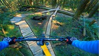
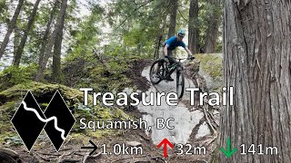
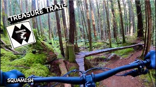
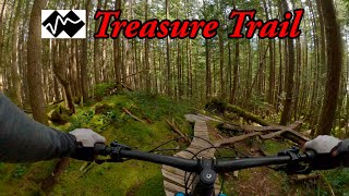
Bring your A-game. This trails is more of a route with bridges connecting rock faces with alternate gaps and jumps.

Local Trail Association
Traditionally Indigenous Territory

Recent Activity on Trail

Past Week
  • 0 rides
  •  
6 Months
  • 9 rides
  • 19.3 km avg distance
All
  • 258 rides
  • Last: Jun 13, 2026
c1c2c3c4
January
February
March
April
May
June
July
August
September
October
November
December
update trails status or condition

Treasure Trail Trail Reports

statusdatedescription
Feb 10, 2026 @ 4:21pm (America/Vancouver)
Feb 10, 2026
Trees all cleared - 2!up ramps are a tad soft and a few slats missing on the odd bridge - time for a work party. Trail is rideable if your able ;)
Nov 11, 2025 @ 4:37pm (America/Vancouver)
Nov 11, 2025
Trees down, runnouts/ transitions are gone, and bridges have some mega flex to them.
Aug 30, 2025 @ 8:57am
Aug 30, 2025
It doesn’t look like the trail sees much traffic nor love. The bridges on the climb are breaking rungs. The rock moves are a spicy as ever. ...
Apr 5, 2025 @ 7:11pm
Apr 5, 2025
Do not ride the awkward stump drop near the bottom. Tree down across the trail about 1 bike length past landing. Hand saw should do it. So glad...
Mar 3, 2025 @ 8:51pm
Mar 3, 2025
more »
Status:
on Feb 10, 2026
Wet
Avg: 4.75 (74 votes)
Your vote: 0

view (1,961)
close
3D
Trail Conditions
  • Unknown
  • Snow Groomed
  • Snow Packed
  • Snow Covered
  • Snow Cover Partial
  • Freeze/thaw Cycle
  • Icy
  • Prevalent Mud
  • Wet
  • Variable
  • Ideal
  • Dry
  • Very Dry
Trail Flow (Ridden Direction)
Trailforks scans users ridelogs to determine the most popular direction each trail is ridden. A good flowing trail network will have most trails flowing in a single direction according to their intension.
The colour categories are based on what percentage of riders are riding a trail in its intended direction.
  • > 96%
  • > 90%
  • > 80%
  • > 70%
  • > 50%
  • < 50%
  • bi-directional trail
  • no data
Trail Last Ridden
Trailforks scans ridelogs to determine the last time a trail was ridden.
  • < 2 days
  • < 1 week
  • < 2 weeks
  • < 1 month
  • < 6 months
  • > 6 months
Trail Ridden Direction
The intended direction a trail should be ridden.
  • Downhill Only
  • Downhill Primary
  • Both Directions
  • Uphill Primary
  • Uphill Only
  • One Direction
Contribute Details
Colors indicate trail is missing specified detail.
  • Description
  • Photos
  • Description & Photos
  • Videos
Trail Popularity ?
Trailforks scans ridelogs to determine which trails are ridden the most in the last 9 months. Trails are compared with nearby trails in the same city region with a possible 25 colour shades. Think of this as a heatmap, more rides = more kinetic energy = warmer colors.
  • most popular
  • popular
  • less popular
  • not popular
ATV/ORV/OHV Filter
Max Vehicle Width
inches
US Cell Coverage
Legend
cell carrier legend

Radar Time
Activity Recordings
Trailforks uses anonymized public activity data. ?
Activity Recordings
Trailforks uses anonymized public activity data. ?
Personal Heatmap
Activity Types
all / none
Options
2
Date range month
Winter Trails
Warning A routing network for winter maps does not exist. Selecting trails using the winter trails layer has been disabled.
Missing Trails
Most Popular
Least Popular
Trails are colored based on popularity. The more popular a trail is, the more red. Less popular trails trend towards green.
Jump Magnitude Heatmap
Heatmap of where riders jump on trails. Zoom in to see individual jumps, click circles to view jump details.
BC Backroad Status

Service Road Atlas is a free to use, community-driven service for viewing and creating reports on the numerous back-country service roads around B.C. and Alberta.

map legend
Slope Aspect
Direction the slope faces
Flat N NE E SE S SW W NW
Trails Deemphasized
Trails are shown in grey.
disable
Only show trails with no bike usage.
Enable
Suggested Layers
Based on selected activity type

    Save the current map location and zoom level as your default home location whenever this page is loaded.

    Save
        Directions to treasure-trail trailhead (49.764790, -123.112060)

        Photos

        194 more »
        399 |
        Jun 23, 2017 @ 12:54pm
        Jun 23, 2017
        1,561 |
        Nov 21, 2016 @ 9:23am
        Nov 21, 2016
        43 |
        Feb 10, 2026 @ 5:12pm
        Feb 10, 2026
        53 |
        Feb 10, 2026 @ 5:11pm
        Feb 10, 2026

        Videos

        52 more »
        youtuber Speedrunning Squamish's Most Technical Trail
        11:56 | 976 | Mar 18, 2022 , Squamish
        youtuber Treasure Trail - Alice Lake - Squamish, BC
        18:11 | 157 | Sep 16, 2022 , Squamish
        youtuber TREASURE TRAIL | Double black trail | Squamish...
        4:57 | 51 | Dec 20, 2023 , Squamish
        youtuber Most feature dense MTB trail in Squamish, BC -...
        17:46 | 185 | Jun 28, 2025 , Squamish

        Articles

        Video: Remy Metailler Rides Squamish's Iconic Treasure Trail
        Apr 22, 2020 from pinkbike.com
        Widely considered Squamish's most technical trail.

        Routes with this trail

        3.0 11 miles 2,094 ft 37 Loop
        The toughest trails in Squamish, compiled. Try not to crash.
        10 miles 2,225 ft 16 Loop
        You donut want to miss this sweet ride! SORCA virtual social ride brought to you by Pinkbike + Sunflower...
        23 miles 4,962 ft 34
        Best Double Blacks of Squamish

        17 Reviews & Comments


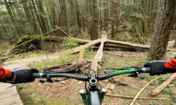
        We hope you've been enjoying Trailforks!

        Create a FREE account to view trail comments and much more.

        • By canadakaTF Pro Trailforks & contributors
        • #3239 - 37,384 views

        Frequently Asked Questions About Treasure Trail

        Where is Treasure Trail located?
        Treasure Trail is located in Alice Lake & Highlands, Squamish, British Columbia, Canada. It is part of the Alice Lake & Highlands trail network. The trailhead is located at coordinates 49.76479, -123.11206.
        How hard is Treasure Trail?
        Treasure Trail is rated as Double Black Diamond difficulty. The physical rating is Hard. The average grade is 10.1%. The climb difficulty is rated Black Diamond.
        What is the elevation gain for Treasure Trail?
        Treasure Trail has 129 ft of elevation gain. The trail has 501 ft of elevation descent. The elevation ranges from 870 ft to 1,326 ft.
        Is Treasure Trail a point to point trail?
        Yes, Treasure Trail is a point to point trail. The direction is Downhill Only. The trail type is singletrack.

        Hit the Trail

        Open in App

        Get this trail on your phone instantly.
        open trail in app

        Download Trail

        Save to wishlist, Garmin & download.
        save the trail

        Find Related Routes

        Find routes and users activities that include this trail.
        find routes for this trail

        You must enter a description before submitting.