more stats
2,080 ft
Distance
25 ft
Climb
-27 ft
Descent
00:02:49
Avg time
-3 ft
Altitude change
72 ft
Altitude min
94 ft
Altitude max
94 ft
Altitude start
92 ft
Altitude end
-0.2%
Grade
-8.5%
Grade max
8.5%
Grade min
561 ft
Distance climb
564 ft
Distance down
922 ft
Distance flat
00:02:49
Avg time

Troll Details

  • Activities
    • Mountain Bike
    • E-Bike
    • Gravel Bike
    • Winter Fat Bike
  • Riding Area
    Ern N Burn
    Ocala, Florida
  • Difficulty Rating
  • Voted Difficulty
    Black Diamond (1 vote)
  • Local Popularity
    45 in Mountain Biking [+]
    • 50 in E-Biking
  • Global Ranking
    #95000 in Mountain Biking
  • Trail Type
    Singletrack
  • Bike Type
    DH, AM, XC, DJ, Fat, CX, Gravel
  • Direction
    One Direction[+]
    • One Direction for E-Biking
    • One Direction for Winter Fat Biking
  • Climb Difficulty
    Black Diamond
  • Physical Rating
    Hard
  • Trail Visibility
    Always easy to follow
  • Dogs Allowed
    Yes
  • eBike Allowed
    Yes up to Class 1
  • TTFs on Trail
    Berm, Bridge, Drop, Jump, Log Ride, Rock Garden
  • Year Opened
    2019

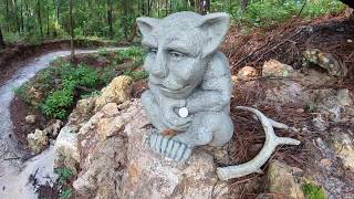
A Troll themed trail that is fun, flowy, yet technical with a Troll Bridge to cross, rock gardens, obstacles, and drops. Take time to stop and enjoy the views as this trail is cut through some of the most beautiful woodlands on the Greenway. **One way now, West to East**

Access Info

Access from Ern N Burn Trail

Disclaimer

NOTE: ONE WAY TRAIL _ WEST TO EAST

Trail Supporters
Local Trail Association
Traditionally Indigenous Territory

Recent Activity on Trail

Past Week
  • 4 rides
  • 13 miles average
6 Months
  • 96 rides
  • 20 miles avg distance
All
  • 803 rides
  • Last: Jun 17, 2026
c1c2c3c4
January
February
March
April
May
June
July
August
September
October
November
December
update trails status or condition

Troll Trail Reports

statusdatedescription
Feb 28, 2026 @ 12:59pm (America/Havana)
Feb 28, 2026
Running very smooth.
Sep 11, 2025 @ 9:41pm (America/New_York)
Sep 11, 2025
The two limerock berms are very slippery so use caution, other than that it’s running well.
Jan 4, 2025 @ 9:54am
Jan 4, 2025
Jan 2, 2025 @ 3:12pm
Jan 2, 2025
Dec 28, 2024 @ 11:01am
Dec 28, 2024
more »
Status:
on Feb 28, 2026
Ideal
Avg: 4.49 (8 votes)
Your vote: 0

view (4,390)
close
3D
Trail Conditions
  • Unknown
  • Snow Groomed
  • Snow Packed
  • Snow Covered
  • Snow Cover Partial
  • Freeze/thaw Cycle
  • Icy
  • Prevalent Mud
  • Wet
  • Variable
  • Ideal
  • Dry
  • Very Dry
Trail Flow (Ridden Direction)
Trailforks scans users ridelogs to determine the most popular direction each trail is ridden. A good flowing trail network will have most trails flowing in a single direction according to their intension.
The colour categories are based on what percentage of riders are riding a trail in its intended direction.
  • > 96%
  • > 90%
  • > 80%
  • > 70%
  • > 50%
  • < 50%
  • bi-directional trail
  • no data
Trail Last Ridden
Trailforks scans ridelogs to determine the last time a trail was ridden.
  • < 2 days
  • < 1 week
  • < 2 weeks
  • < 1 month
  • < 6 months
  • > 6 months
Trail Ridden Direction
The intended direction a trail should be ridden.
  • Downhill Only
  • Downhill Primary
  • Both Directions
  • Uphill Primary
  • Uphill Only
  • One Direction
Contribute Details
Colors indicate trail is missing specified detail.
  • Description
  • Photos
  • Description & Photos
  • Videos
Trail Popularity ?
Trailforks scans ridelogs to determine which trails are ridden the most in the last 9 months. Trails are compared with nearby trails in the same city region with a possible 25 colour shades. Think of this as a heatmap, more rides = more kinetic energy = warmer colors.
  • most popular
  • popular
  • less popular
  • not popular
ATV/ORV/OHV Filter
Max Vehicle Width
inches
US Cell Coverage
Legend
cell carrier legend

Radar Time
Activity Recordings
Trailforks uses anonymized public activity data. ?
Activity Recordings
Trailforks uses anonymized public activity data. ?
Personal Heatmap
Activity Types
all / none
Options
2
Date range month
Winter Trails
Warning A routing network for winter maps does not exist. Selecting trails using the winter trails layer has been disabled.
Missing Trails
Most Popular
Least Popular
Trails are colored based on popularity. The more popular a trail is, the more red. Less popular trails trend towards green.
Jump Magnitude Heatmap
Heatmap of where riders jump on trails. Zoom in to see individual jumps, click circles to view jump details.
BC Backroad Status

Service Road Atlas is a free to use, community-driven service for viewing and creating reports on the numerous back-country service roads around B.C. and Alberta.

map legend
Slope Aspect
Direction the slope faces
Flat N NE E SE S SW W NW
Trails Deemphasized
Trails are shown in grey.
disable
Only show trails with no bike usage.
Enable
Suggested Layers
Based on selected activity type

    Save the current map location and zoom level as your default home location whenever this page is loaded.

    Save
        Directions to troll-164065 trailhead (29.045640, -82.256410)

        Photos

        11 more »
        59 |
        Oct 22, 2023 @ 10:52am
        Oct 22, 2023
        116 |
        Mar 13, 2023 @ 2:57am
        Mar 13, 2023
        147 |
        Oct 16, 2022 @ 4:18am
        Oct 16, 2022
        136 |
        Aug 22, 2022 @ 12:11pm
        Aug 22, 2022

        Videos

        1 more »
        Troll 'Full trail' Feature
        6:34 | 1167 | Jun 12, 2019 , Ocala

        Routes with this trail

        5.0 43 miles 1,145 ft 24 Out & Back
        69km or 42miles from parking to Vortex parking and back, all without repeating any trail.
        73 miles 1,854 ft 38 Point to Point
        Full run through Santos, Vortex, and Spider Kingdom. Features the most fun trails you can ride in Florida...
        30 miles 768 ft 18 Point to Point Race
        This is the outbound lap of a loop course. Please see inbound lap for second half of this event. Both laps...

        6 Reviews & Comments


        We hope you've been enjoying Trailforks!

        Create a FREE account to view trail comments and much more.

        • By TmhorvathTF Pro & contributors
        • #164065 - 4,268 views

        Frequently Asked Questions About Troll

        Where is Troll located?
        Troll is located in Ern N Burn, Ocala, Florida, United States. It is part of the Ern N Burn trail network. The trailhead is located at coordinates 29.04564, -82.25641.
        How hard is Troll?
        Troll is rated as Black Diamond difficulty. The physical rating is Hard. The average grade is 0.2%. The climb difficulty is rated Black Diamond.
        What is the elevation gain for Troll?
        Troll has 25 ft of elevation gain. The trail has 27 ft of elevation descent. The elevation ranges from 72 ft to 94 ft.
        Is Troll a point to point trail?
        Yes, Troll is a point to point trail. The direction is One Direction. The trail type is singletrack.

        Hit the Trail

        Open in App

        Get this trail on your phone instantly.
        open trail in app

        Download Trail

        Save to wishlist, Garmin & download.
        save the trail

        Find Related Routes

        Find routes and users activities that include this trail.
        find routes for this trail

        You must enter a description before submitting.