more stats
7.5 miles
Distance
1,336 ft
Climb
-2,828 ft
Descent
01:13:08
Avg time
-1,492 ft
Altitude change
4,090 ft
Altitude min
5,804 ft
Altitude max
5,804 ft
Altitude start
4,314 ft
Altitude end
-3.8%
Grade
-53%
Grade max
30.6%
Grade min
2 miles
Distance climb
5 miles
Distance down
1,552 ft
Distance flat
01:13:08
Avg time

Tronsen Ridge Details

  • Activities
    • Mountain Bike
    • E-Bike
    • Hike
    • Trail Running
    • Dirtbike/Moto
  • Riding Area
    Table Mountain
    Ellensburg, Washington
  • Ref Number
    #1204
  • Difficulty Rating
  • Local Popularity
    70 in Mountain Biking [+]
    • 90 in E-Biking
    • 95 in Trail Running
    • 5 in Hiking
    • 5 in Dirtbiking
  • Global Ranking
    #74880 in Mountain Biking [+]
    • #24629 in E-Biking
    • #20707 in Trail Running
    • #131201 in Hiking
    • #3320 in Dirtbiking
  • Trail Type
    Singletrack
  • Bike Type
    AM, XC
  • Direction
    Both Directions
    Popular Direction Shown
  • Climb Difficulty
    Black Diamond
  • Physical Rating
    Hard
  • Season
    May - Oct
  • Dogs Allowed
    Yes
  • eBike Allowed
    Yes up to Class 1
  • Land Owner
    USFS

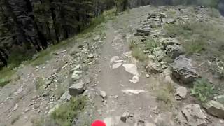
Loose, dry and rocky. Make sure you take enough water for about 3 hours of work in hot dry conditions. There is no water between Haney Meadows and Devils Gulch. TRT loses altitude grudgingly, with quite a few up-pitches. Red Hill trail also follows a ridge due north from where Tronsen Ridge heads NW, so it is quite up-and-down too. Most of the elevation loss comes while on Red Hill and Red Hlll Spur trails, which proceed a bit faster than the TRT. The lower part of Red Hill Spur was pretty closed in with brush, so keep speed in check going downhill

Immediately, you know it is a degree or two harder than Mission Ridge. The steeps are steeper, there is more exposure, and for my ability, a lot more hike-a-bike.(Closed to motorized use October 15 through June 15)

Disclaimer

Incredible views, just be careful and pack water

Trail Supporters

  • USFS
    Land Manager
Local Trail Association
Traditionally Indigenous Territory

Recent Activity on Trail

Past Week
  • 0 rides
  •  
6 Months
  • 0 rides
  •  
All
  • 24 rides
  • Last: Aug 17, 2025
c1c2c3c4
January
February
March
April
May
June
July
August
September
October
November
December
update trails status or condition

Tronsen Ridge Trail Reports

statusdatedescription
May 17, 2026 @ 8:12pm (America/Los_Angeles)
May 17, 2026
We went up about a mile from Five mile road. Cleared a few blowdowns but then hit what seemed like a very long stretch of downed trees so we...
Sep 25, 2025 @ 9:10am (America/Los_Angeles)
Sep 25, 2025
Due to the Labor Mountain Fire, the Forest Service has issued a closure for this trail through December 31, 2025 (unless lifted earlier) to keep...
Oct 11, 2024 @ 2:09pm
Oct 11, 2024
All clear. Bone Dry. Some moto chunder and moondust but not too bad.
Aug 8, 2024 @ 1:31am
Aug 8, 2024
Clear. Dry. Skill testing uphills. Dry. No trees. Dry.
Jun 8, 2024 @ 9:25pm
Jun 8, 2024
Running well. Only one 18" tree down on the trail itself. A handful on the access road to the upper trailhead, but nothing that would deter a ride.
more »
Status:
on May 17, 2026
Dry
Avg: 4.16 (6 votes)
Your vote: 0

view (80)
close
3D
Trail Conditions
  • Unknown
  • Snow Groomed
  • Snow Packed
  • Snow Covered
  • Snow Cover Partial
  • Freeze/thaw Cycle
  • Icy
  • Prevalent Mud
  • Wet
  • Variable
  • Ideal
  • Dry
  • Very Dry
Trail Flow (Ridden Direction)
Trailforks scans users ridelogs to determine the most popular direction each trail is ridden. A good flowing trail network will have most trails flowing in a single direction according to their intension.
The colour categories are based on what percentage of riders are riding a trail in its intended direction.
  • > 96%
  • > 90%
  • > 80%
  • > 70%
  • > 50%
  • < 50%
  • bi-directional trail
  • no data
Trail Last Ridden
Trailforks scans ridelogs to determine the last time a trail was ridden.
  • < 2 days
  • < 1 week
  • < 2 weeks
  • < 1 month
  • < 6 months
  • > 6 months
Trail Ridden Direction
The intended direction a trail should be ridden.
  • Downhill Only
  • Downhill Primary
  • Both Directions
  • Uphill Primary
  • Uphill Only
  • One Direction
Contribute Details
Colors indicate trail is missing specified detail.
  • Description
  • Photos
  • Description & Photos
  • Videos
Trail Popularity ?
Trailforks scans ridelogs to determine which trails are ridden the most in the last 9 months. Trails are compared with nearby trails in the same city region with a possible 25 colour shades. Think of this as a heatmap, more rides = more kinetic energy = warmer colors.
  • most popular
  • popular
  • less popular
  • not popular
ATV/ORV/OHV Filter
Max Vehicle Width
inches
US Cell Coverage
Legend
cell carrier legend

Radar Time
Activity Recordings
Trailforks uses anonymized public activity data. ?
Activity Recordings
Trailforks uses anonymized public activity data. ?
Personal Heatmap
Activity Types
all / none
Options
2
Date range month
Winter Trails
Warning A routing network for winter maps does not exist. Selecting trails using the winter trails layer has been disabled.
Missing Trails
Most Popular
Least Popular
Trails are colored based on popularity. The more popular a trail is, the more red. Less popular trails trend towards green.
Jump Magnitude Heatmap
Heatmap of where riders jump on trails. Zoom in to see individual jumps, click circles to view jump details.
BC Backroad Status

Service Road Atlas is a free to use, community-driven service for viewing and creating reports on the numerous back-country service roads around B.C. and Alberta.

map legend
Slope Aspect
Direction the slope faces
Flat N NE E SE S SW W NW
Trails Deemphasized
Trails are shown in grey.
disable
Only show trails with no bike usage.
Enable
Suggested Layers
Based on selected activity type

    Save the current map location and zoom level as your default home location whenever this page is loaded.

    Save
        Directions to tronsen-ridge trailhead (47.333600, -120.526660)

        Photos

        23 more »
        828 |
        Jul 29, 2012 @ 10:34am
        Jul 29, 2012
        662 |
        Jul 29, 2012 @ 10:35am
        Jul 29, 2012
        937 |
        Jul 29, 2012 @ 10:35am
        Jul 29, 2012
        769 |
        Jul 29, 2012 @ 10:35am
        Jul 29, 2012

        Videos

        2 more »
        Cliffside dirtbike singletrack to die for!
        10:56 | 144 | Jan 4, 2025 , Ellensburg
        Tronsen Ridge trail #1204
        10:38 | 99 | Jan 4, 2025 , Ellensburg

        Routes with this trail

        3.0 12 miles 2,048 ft 8 Point to Point
        This is one of the better ways to ride . Leaving a vehicle at the bottom of the 5 mile road and shuttling...
        3 miles 596 ft 4 Point to Point
        A shorter trail option than the entire , with a focus on those shuttling nearby Mission Ridge and trails....
        10 miles 1,225 ft 2
        This is one of our favorite flow routes in the Wenatchee Valley and is featured in Freehub Magazine's...

        4 Reviews & Comments


        We hope you've been enjoying Trailforks!

        Create a FREE account to view trail comments and much more.

        Frequently Asked Questions About Tronsen Ridge

        Where is Tronsen Ridge located?
        Tronsen Ridge is located in Table Mountain, Ellensburg, Washington, United States. It is part of the Table Mountain trail network. The trailhead is located at coordinates 47.3336, -120.52666.
        How hard is Tronsen Ridge?
        Tronsen Ridge is rated as Black Diamond difficulty. The physical rating is Hard. The average grade is 3.8%. The climb difficulty is rated Black Diamond.
        What is the elevation gain for Tronsen Ridge?
        Tronsen Ridge has 1,336 ft of elevation gain. The trail has 2,828 ft of elevation descent. The elevation ranges from 4,090 ft to 5,804 ft.
        Is Tronsen Ridge a point to point trail?
        Tronsen Ridge is not a point to point trail. The direction is Both Directions. The trail type is singletrack.

        Hit the Trail

        Open in App

        Get this trail on your phone instantly.
        open trail in app

        Download Trail

        Save to wishlist, Garmin & download.
        save the trail

        Find Related Routes

        Find routes and users activities that include this trail.
        find routes for this trail

        You must enter a description before submitting.