more stats
1.1 miles
Distance
-577 ft
Descent
00:14:05
Avg time
-578 ft
Altitude change
1,124 ft
Altitude min
1,702 ft
Altitude max
1,702 ft
Altitude start
1,125 ft
Altitude end
-9.9%
Grade
-50.4%
Grade max
-0.5%
Grade min
1 mile
Distance down
148 ft
Distance flat
00:14:05
Avg time

Trzygłów Details

  • Activities
    • Mountain Bike
  • Riding Area
  • Difficulty Rating
  • Voted Difficulty
    Red (1 vote)
  • Local Popularity
    85 in Mountain Biking
  • Global Ranking
    #3939 in Mountain Biking
  • Trail Type
    Singletrack
  • Bike Type
    DH, AM
  • Direction
    Downhill Only
    Popular Direction Shown
  • Physical Rating
    Hard
  • Trail Visibility
    Always easy to follow
  • Season
    maj-październik
  • Alpine Trail
    Yes
  • Dogs Allowed
    Yes
  • eBike Allowed
  • TTFs on Trail
    Drop, Jump, Gap Jump, Ladder Bridge, Log Ride, Rock Garden
  • Land Owner

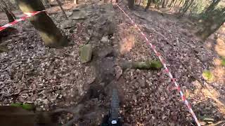
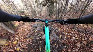
Ścieżki enduro w Górach Świętokrzyskich. Wykonane przez Stowarzyszenie Ostrower i przyjaciół, przy wsparciu Nadleśnictwa Łagów, Wójta gminy Waśniów i Grupę Pałasz Ubezpieczenia. Single mają naturalny, górski charakter.

Access Info

Najbliższa miejscowośc to Witosławice i Wronów. Polecamy parking pod górą Witosławską przed szlabanem. W weekendy szlaban powinien być otwarty, można wtedy drogą szutrową (ok 1.5 km) dojechać na parking bezpośrednio przy ścieżkach. Droga od Wronowa wymaga auta wyżej zawieszonego.

Recent Activity on Trail

Past Week
  • 0 rides
  •  
6 Months
  • 10 rides
  • 12 miles avg distance
All
  • 116 rides
  • Last: Jun 4, 2026
c1c2c3c4
January
February
March
April
May
June
July
August
September
October
November
December
Status:
on Apr 5, 2026
Ideal
Avg: 4.24 (7 votes)
Your vote: 0

view (1,818)
close
3D
Trail Conditions
  • Unknown
  • Snow Groomed
  • Snow Packed
  • Snow Covered
  • Snow Cover Partial
  • Freeze/thaw Cycle
  • Icy
  • Prevalent Mud
  • Wet
  • Variable
  • Ideal
  • Dry
  • Very Dry
Trail Flow (Ridden Direction)
Trailforks scans users ridelogs to determine the most popular direction each trail is ridden. A good flowing trail network will have most trails flowing in a single direction according to their intension.
The colour categories are based on what percentage of riders are riding a trail in its intended direction.
  • > 96%
  • > 90%
  • > 80%
  • > 70%
  • > 50%
  • < 50%
  • bi-directional trail
  • no data
Trail Last Ridden
Trailforks scans ridelogs to determine the last time a trail was ridden.
  • < 2 days
  • < 1 week
  • < 2 weeks
  • < 1 month
  • < 6 months
  • > 6 months
Trail Ridden Direction
The intended direction a trail should be ridden.
  • Downhill Only
  • Downhill Primary
  • Both Directions
  • Uphill Primary
  • Uphill Only
  • One Direction
Contribute Details
Colors indicate trail is missing specified detail.
  • Description
  • Photos
  • Description & Photos
  • Videos
Trail Popularity ?
Trailforks scans ridelogs to determine which trails are ridden the most in the last 9 months. Trails are compared with nearby trails in the same city region with a possible 25 colour shades. Think of this as a heatmap, more rides = more kinetic energy = warmer colors.
  • most popular
  • popular
  • less popular
  • not popular
ATV/ORV/OHV Filter
Max Vehicle Width
inches
US Cell Coverage
Legend
cell carrier legend

Radar Time
Activity Recordings
Trailforks uses anonymized public activity data. ?
Activity Recordings
Trailforks uses anonymized public activity data. ?
Personal Heatmap
Activity Types
all / none
Options
2
Date range month
Winter Trails
Warning A routing network for winter maps does not exist. Selecting trails using the winter trails layer has been disabled.
Missing Trails
Most Popular
Least Popular
Trails are colored based on popularity. The more popular a trail is, the more red. Less popular trails trend towards green.
Jump Magnitude Heatmap
Heatmap of where riders jump on trails. Zoom in to see individual jumps, click circles to view jump details.
BC Backroad Status

Service Road Atlas is a free to use, community-driven service for viewing and creating reports on the numerous back-country service roads around B.C. and Alberta.

map legend
Slope Aspect
Direction the slope faces
Flat N NE E SE S SW W NW
Trails Deemphasized
Trails are shown in grey.
disable
Only show trails with no bike usage.
Enable
Suggested Layers
Based on selected activity type

    Save the current map location and zoom level as your default home location whenever this page is loaded.

    Save
        Directions to trzyg-ow trailhead (50.826570, 21.174500)

        Photos

        7 more »
        205 |
        Oct 27, 2021 @ 2:53pm
        Oct 27, 2021
        247 |
        Oct 27, 2021 @ 2:53pm
        Oct 27, 2021
        186 |
        Sep 15, 2021 @ 2:26pm
        Sep 15, 2021
        168 |
        Sep 15, 2021 @ 2:25pm
        Sep 15, 2021

        Videos

        4 more »
        Jeleniowskie Ścieżki OS4 Trzygłów raw...
        3:50 | 169 | Apr 29, 2023 , Waśniów
        Trzygłów RAW
        5:24 | 133 | Oct 31, 2022 , Waśniów
        Jeleniowskie Ścieżki - Trasa Trzygłów - Z...
        5:14 | 324 | Oct 27, 2021 , Waśniów
        Jeleniowskie Ścieżki - Trzygłów
        5:01 | 376 | Sep 7, 2021 , Waśniów

        Reviews / Comments

        No reviews yet, be the first to write a review or ask a question.
        Use trail reports to comment on trail conditions.


        We hope you've been enjoying Trailforks!

        Create a FREE account to view trail comments and much more.

        • By MarcinWysocki & contributors
        • #461852 - 1,245 views

        Frequently Asked Questions About Trzygłów

        Where is Trzygłów located?
        Trzygłów is located in Jeleniowskie Ścieżki, Waśniów, Poland. It is part of the Jeleniowskie Ścieżki trail network. The trailhead is located at coordinates 50.82657, 21.1745.
        How hard is Trzygłów?
        Trzygłów is rated as Red difficulty. The physical rating is Hard. The average grade is 9.9%.
        What is the elevation gain for Trzygłów?
        The trail has 176 m of elevation descent. The elevation ranges from 343 m to 519 m.
        Is Trzygłów a point to point trail?
        Yes, Trzygłów is a point to point trail. The direction is Downhill Only. The trail type is singletrack.

        Hit the Trail

        Open in App

        Get this trail on your phone instantly.
        open trail in app

        Download Trail

        Save to wishlist, Garmin & download.
        save the trail

        Find Related Routes

        Find routes and users activities that include this trail.
        find routes for this trail

        You must enter a description before submitting.