


Open in App
Get this trail on your phone instantly.

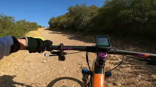
Fireroad that runs north-south through the tunnels area. The middle is known as "cardiac hill" because it is stupidly steep.
The northern point connects to McGonigle Canyon, and from there you can connect to areas north-east like Lusardi and Black Mountain. The horse-shoe turn at the north side is also quite steep, also known as "goat wrencher".
Exercise care in avoiding vernal pools
| c1 | c2 | c3 | c4 |
|---|---|---|---|
January | February | March | April |
May | June | July | August |
September | October | November | December |

Service Road Atlas is a free to use, community-driven service for viewing and creating reports on the numerous back-country service roads around B.C. and Alberta.
Save the current map location and zoom level as your default home location whenever this page is loaded.
SaveWe hope you've been enjoying Trailforks!
Create a FREE account to view trail comments and much more.
You must enter a description before submitting.

