more stats
2.7 miles
Distance
591 ft
Climb
-588 ft
Descent
00:28:18
Avg time
3 ft
Altitude change
463 ft
Altitude min
1,046 ft
Altitude max
465 ft
Altitude start
468 ft
Altitude end
0.022%
Grade
-30.806%
Grade max
20.512%
Grade min
2 miles
Distance climb
1 mile
Distance down
487 ft
Distance flat
00:28:18
Avg time

Turtle Ridge Details

  • Activities
    • Mountain Bike
    • Hike
    • Trail Running
  • Riding Area
    Irvine Open Space
    Irvine, California
  • Difficulty Rating
  • Voted Difficulty
    Blue (1 vote)
  • Local Popularity
    85 in Mountain Biking [+]
    • 80 in Trail Running
    • 90 in Hiking
  • Global Ranking
    #61538 in Mountain Biking [+]
    • #68584 in Trail Running
    • #56109 in Hiking
  • Trail Type
    Singletrack
  • Bike Type
    AM, XC
  • Direction
    Both Directions
  • Climb Difficulty
    Blue
  • Physical Rating
    Moderate
  • Season
    Year Round
  • Dogs Allowed
    Yes
  • TTFs on Trail
    Berm, Rock Garden, Skinny
  • Land Owner
    County of Orange

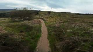
Starts with an easy uphill climb, relatively tame with one small kicker near the start. On the start of the downhill there's some steep challenging single track with small rock sections. This section is very tight and technical, I would rate this part of the trail as a "Black Diamond". The rest of the trail is relatively easy, with switchbacks that line the side of the hill.

Local Trail Association
Traditionally Indigenous Territory

Recent Activity on Trail

Past Week
  • 0 rides
  •  
6 Months
  • 14 rides
  • 17 miles avg distance
All
  • 229 rides
  • Last: Jun 24, 2026
c1c2c3c4
January
February
March
April
May
June
July
August
September
October
November
December
update trails status or condition

Turtle Ridge Trail Reports

statusdatedescription
Jun 5, 2026 @ 1:15pm (America/Los_Angeles)
Jun 5, 2026
May 20, 2026 @ 2:44pm (America/Los_Angeles)
May 20, 2026
Crap ton of spiky Italian thistle on the downhill/eastern side of the hill. Biking through it is very uncomfortable and you'll be pricked by the...
Oct 18, 2024 @ 10:05am
Oct 18, 2024
All clear.
Jul 25, 2024 @ 9:51am
Jul 25, 2024
Large tree down across trail, blocking trail
Jul 14, 2024 @ 12:37am
Jul 14, 2024
more »
Status:
on Jun 5, 2026
Dry
Avg: 4.06 (11 votes)
Your vote: 0

view (3,110)
close
3D
Trail Conditions
  • Unknown
  • Snow Groomed
  • Snow Packed
  • Snow Covered
  • Snow Cover Partial
  • Freeze/thaw Cycle
  • Icy
  • Prevalent Mud
  • Wet
  • Variable
  • Ideal
  • Dry
  • Very Dry
Trail Flow (Ridden Direction)
Trailforks scans users ridelogs to determine the most popular direction each trail is ridden. A good flowing trail network will have most trails flowing in a single direction according to their intension.
The colour categories are based on what percentage of riders are riding a trail in its intended direction.
  • > 96%
  • > 90%
  • > 80%
  • > 70%
  • > 50%
  • < 50%
  • bi-directional trail
  • no data
Trail Last Ridden
Trailforks scans ridelogs to determine the last time a trail was ridden.
  • < 2 days
  • < 1 week
  • < 2 weeks
  • < 1 month
  • < 6 months
  • > 6 months
Trail Ridden Direction
The intended direction a trail should be ridden.
  • Downhill Only
  • Downhill Primary
  • Both Directions
  • Uphill Primary
  • Uphill Only
  • One Direction
Contribute Details
Colors indicate trail is missing specified detail.
  • Description
  • Photos
  • Description & Photos
  • Videos
Trail Popularity ?
Trailforks scans ridelogs to determine which trails are ridden the most in the last 9 months. Trails are compared with nearby trails in the same city region with a possible 25 colour shades. Think of this as a heatmap, more rides = more kinetic energy = warmer colors.
  • most popular
  • popular
  • less popular
  • not popular
ATV/ORV/OHV Filter
Max Vehicle Width
inches
US Cell Coverage
Legend
cell carrier legend

Radar Time
Activity Recordings
Trailforks uses anonymized public activity data. ?
Activity Recordings
Trailforks uses anonymized public activity data. ?
Personal Heatmap
Activity Types
all / none
Options
2
Date range month
Winter Trails
Warning A routing network for winter maps does not exist. Selecting trails using the winter trails layer has been disabled.
Missing Trails
Most Popular
Least Popular
Trails are colored based on popularity. The more popular a trail is, the more red. Less popular trails trend towards green.
Jump Magnitude Heatmap
Heatmap of where riders jump on trails. Zoom in to see individual jumps, click circles to view jump details.
BC Backroad Status

Service Road Atlas is a free to use, community-driven service for viewing and creating reports on the numerous back-country service roads around B.C. and Alberta.

map legend
Slope Aspect
Direction the slope faces
Flat N NE E SE S SW W NW
Trails Deemphasized
Trails are shown in grey.
disable
Only show trails with no bike usage.
Enable
Suggested Layers
Based on selected activity type

    Save the current map location and zoom level as your default home location whenever this page is loaded.

    Save
        Directions to turtle-ridge trailhead (33.624680, -117.825220)

        Photos

        7 more »
        100 |
        Dec 11, 2023 @ 7:52pm
        Dec 11, 2023
        129 |
        Dec 11, 2023 @ 7:51pm
        Dec 11, 2023
        102 |
        Dec 11, 2023 @ 7:51pm
        Dec 11, 2023
        342 |
        May 9, 2018 @ 7:08pm
        May 9, 2018

        Videos

        3 more »
        youtuber Turtle Ridge XC MTB Trail | Irvine 2021
        6:27 | 722 | Feb 18, 2021 , Irvine
        Turtle Ridge Downhill MTB - Irvine CA |...
        4:36 | 193 | Jan 17, 2024 , Irvine
        Turtle Ridge DH Mountain Bike Trail - Bommer...
        4:39 | 841 | Jul 24, 2019 , Irvine

        Routes with this trail

        7 miles 930 ft 3 Loop
        Cycling Club @ UCI Crystal Cove Beginner Route

        2 Reviews & Comments


        We hope you've been enjoying Trailforks!

        Create a FREE account to view trail comments and much more.

        • By hsracerTF Pro & contributors
        • #17314 - 5,648 views

        Frequently Asked Questions About Turtle Ridge

        Where is Turtle Ridge located?
        Turtle Ridge is located in Irvine Open Space, Irvine, California, United States. It is part of the Irvine Open Space trail network. The trailhead is located at coordinates 33.62468, -117.82522.
        How hard is Turtle Ridge?
        Turtle Ridge is rated as Blue difficulty. The physical rating is Moderate. The average grade is 0.022%. The climb difficulty is rated Blue.
        What is the elevation gain for Turtle Ridge?
        Turtle Ridge has 591 ft of elevation gain. The trail has 588 ft of elevation descent. The elevation ranges from 463 ft to 1,046 ft.
        Is Turtle Ridge a point to point trail?
        Turtle Ridge is not a point to point trail. The direction is Both Directions. The trail type is singletrack.

        Hit the Trail

        Open in App

        Get this trail on your phone instantly.
        open trail in app

        Download Trail

        Save to wishlist, Garmin & download.
        save the trail

        Find Related Routes

        Find routes and users activities that include this trail.
        find routes for this trail

        You must enter a description before submitting.