more stats
1.9 miles
Distance
3 ft
Climb
-1,527 ft
Descent
00:21:20
Avg time
-1,524 ft
Altitude change
1,406 ft
Altitude min
2,930 ft
Altitude max
2,930 ft
Altitude start
1,407 ft
Altitude end
-14.9%
Grade
-58.5%
Grade max
4.9%
Grade min
62 ft
Distance climb
2 miles
Distance down
197 ft
Distance flat
00:21:20
Avg time

TW+ Details

  • Activities
    • Mountain Bike
    • E-Bike
  • Riding Area
  • AKA
    Traska Wilkowicka
  • Difficulty Rating
  • Voted Difficulty
    Proline (4 votes)
  • Local Popularity
    55 in Mountain Biking [+]
    • 55 in E-Biking
  • Global Ranking
    #19477 in Mountain Biking [+]
    • #3742 in E-Biking
  • Trail Type
    Singletrack
  • Bike Type
    DH, AM
  • Physical Rating
    Hard
  • Dogs Allowed
    Yes
  • eBike Allowed
    Yes up to Class 1
  • TTFs on Trail
    Berm, Drop, Jump, Gap Jump, Rock Garden
  • Ride in Rain
    Yes

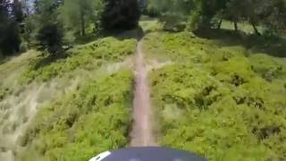
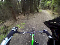
Pierwszym twórcą dolnej części trasy była ekipa WFRT, trasa zaczynała się wtedy od drogi dojazdowej przy Chatce na Rogaczu (2010-2015). Dzięki przeprowadzeniu zawodów Enduro Trails została ona przedłużona najpierw o odcinek ponad drogą (2015) a następnie (2020) aż do samej góry (obecny start jest przy sklepie na Magurce). Nowa linia łączy się ze starą "Traską Wilkowicką" dopiero w okolicach drewnianego dropa przed ścianką. Górna część to dosyć łatwy i niezbyt stromy singletrack, im niżej tym trasa staje się trudniejsza, momentami szybka, stroma z kilkoma ciekawymi elementami dh/fr..

Bike Park

Recent Activity on Trail

Past Week
  • 0 rides
  •  
6 Months
  • 16 rides
  • 10 miles avg distance
All
  • 119 rides
  • Last: Jun 21, 2026
c1c2c3c4
January
February
March
April
May
June
July
August
September
October
November
December
Status:
on Aug 17, 2025
Avg: 4.66 (18 votes)
Your vote: 0

view (1,325)
close
3D
Trail Conditions
  • Unknown
  • Snow Groomed
  • Snow Packed
  • Snow Covered
  • Snow Cover Partial
  • Freeze/thaw Cycle
  • Icy
  • Prevalent Mud
  • Wet
  • Variable
  • Ideal
  • Dry
  • Very Dry
Trail Flow (Ridden Direction)
Trailforks scans users ridelogs to determine the most popular direction each trail is ridden. A good flowing trail network will have most trails flowing in a single direction according to their intension.
The colour categories are based on what percentage of riders are riding a trail in its intended direction.
  • > 96%
  • > 90%
  • > 80%
  • > 70%
  • > 50%
  • < 50%
  • bi-directional trail
  • no data
Trail Last Ridden
Trailforks scans ridelogs to determine the last time a trail was ridden.
  • < 2 days
  • < 1 week
  • < 2 weeks
  • < 1 month
  • < 6 months
  • > 6 months
Trail Ridden Direction
The intended direction a trail should be ridden.
  • Downhill Only
  • Downhill Primary
  • Both Directions
  • Uphill Primary
  • Uphill Only
  • One Direction
Contribute Details
Colors indicate trail is missing specified detail.
  • Description
  • Photos
  • Description & Photos
  • Videos
Trail Popularity ?
Trailforks scans ridelogs to determine which trails are ridden the most in the last 9 months. Trails are compared with nearby trails in the same city region with a possible 25 colour shades. Think of this as a heatmap, more rides = more kinetic energy = warmer colors.
  • most popular
  • popular
  • less popular
  • not popular
ATV/ORV/OHV Filter
Max Vehicle Width
inches
US Cell Coverage
Legend
cell carrier legend

Radar Time
Activity Recordings
Trailforks uses anonymized public activity data. ?
Activity Recordings
Trailforks uses anonymized public activity data. ?
Personal Heatmap
Activity Types
all / none
Options
2
Date range month
Winter Trails
Warning A routing network for winter maps does not exist. Selecting trails using the winter trails layer has been disabled.
Missing Trails
Most Popular
Least Popular
Trails are colored based on popularity. The more popular a trail is, the more red. Less popular trails trend towards green.
Jump Magnitude Heatmap
Heatmap of where riders jump on trails. Zoom in to see individual jumps, click circles to view jump details.
BC Backroad Status

Service Road Atlas is a free to use, community-driven service for viewing and creating reports on the numerous back-country service roads around B.C. and Alberta.

map legend
Slope Aspect
Direction the slope faces
Flat N NE E SE S SW W NW
Trails Deemphasized
Trails are shown in grey.
disable
Only show trails with no bike usage.
Enable
Suggested Layers
Based on selected activity type

    Save the current map location and zoom level as your default home location whenever this page is loaded.

    Save
        Directions to tw trailhead (49.778590, 19.126710)

        Photos

        48 more »
        703 |
        Jun 9, 2016 @ 3:01pm
        Jun 9, 2016
        586 |
        Jun 9, 2016 @ 2:58pm
        Jun 9, 2016
        116 |
        Aug 22, 2024 @ 10:47am
        Aug 22, 2024
        109 |
        Oct 22, 2023 @ 9:46am
        Oct 22, 2023

        Videos

        4 more »
        TW+, Magurka, Bielsko-Biała - czerwona, ale...
        17:51 | 312 | May 28, 2024 , Bielsko-Biała
        Trasa Wilkowicka | Downhill/Enduro | Bielsko...
        1543 | Jul 28, 2016 , Bielsko-Biała
        Trasa Wilkowicka
        3:33 | 574 | May 12, 2017 , Bielsko-Biała
        WFRT, Wilkowice Freeride Team
        18:25 | 2629 | Aug 8, 2010 , Bielsko-Biała

        3 Reviews & Comments


        We hope you've been enjoying Trailforks!

        Create a FREE account to view trail comments and much more.

        Frequently Asked Questions About TW+

        Where is TW+ located?
        TW+ is located in Enduro Trails Bielsko-Biała, Bielsko-Biała, Poland. It is part of the Enduro Trails Bielsko-Biała trail network. The trailhead is located at coordinates 49.77859, 19.12671.
        How hard is TW+?
        TW+ is rated as Red difficulty. The physical rating is Hard. The average grade is 14.9%.
        What is the elevation gain for TW+?
        TW+ has 1 m of elevation gain. The trail has 465 m of elevation descent. The elevation ranges from 429 m to 893 m.
        How long is TW+?
        TW+ is 3.1 km long. The trail type is singletrack.

        Hit the Trail

        Open in App

        Get this trail on your phone instantly.
        open trail in app

        Download Trail

        Save to wishlist, Garmin & download.
        save the trail

        Find Related Routes

        Find routes and users activities that include this trail.
        find routes for this trail

        You must enter a description before submitting.