more stats
3.3 miles
Distance
29 ft
Climb
-1,503 ft
Descent
00:16:06
Avg time
-1,474 ft
Altitude change
6,845 ft
Altitude min
8,333 ft
Altitude max
8,319 ft
Altitude start
6,844 ft
Altitude end
-8.4%
Grade
-42.3%
Grade max
9.8%
Grade min
1,253 ft
Distance climb
3 miles
Distance down
285 ft
Distance flat
00:16:06
Avg time

Tyrolian Downhill Trail Details

  • Activities
    • Mountain Bike
    • Hike
    • Trail Running
  • Riding Area
    East Shore
    Incline Village, Nevada
  • Difficulty Rating
  • Voted Difficulty
    Black Diamond (2 votes)
  • Local Popularity
    65 in Mountain Biking [+]
    • 5 in Trail Running
    • 5 in Hiking
  • Global Ranking
    #19524 in Mountain Biking [+]
    • #111003 in Trail Running
    • #107046 in Hiking
  • Trail Type
    Singletrack
  • Bike Type
    DH, AM
  • Direction
    Downhill Only
    Popular Direction Shown
  • Climb Difficulty
    Black Diamond
  • Physical Rating
    Moderate
  • Trail Visibility
    Always easy to follow
  • Season
    May-November
  • Dogs Allowed
    Yes
  • TTFs on Trail
    Berm, Drop, Jump, Rock Garden
  • Land Owner
    USFS

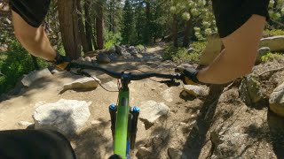
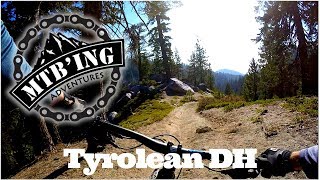
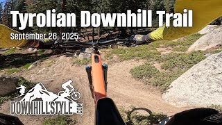
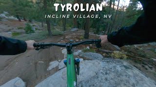
One of the better DH trails in the Tahoe area, this trail gets regular maintenance and improvements. Jumps and berms have been added to a few places along the trail. The trail mostly rips, though there are 2 or 3 sections with some big chunks to navigate. The trail can range from tacky to sandy/dusty depending on season and rain frequency. The close proximity to Diamond Peak ski area and housing there attracts some hikers, so please ride in control.

Access Info

Easy shuttle if desired with dropoff at Tahoe Meadows and pickup at Diamond Peak. Another option is to ride the Hwy 431 up from Incline Village, or alternatively, the Old Mt Rose highway (decommissioned) for a car-free option. Please avoid riding up Tyrolean DH. You can also catch the lower half of Tyrolian from the Incline Flume, which you can catch off Tunnel Creek Rd.

Trail Supporters
Local Trail Association
Traditionally Indigenous Territory

Recent Activity on Trail

Past Week
  • 4 rides
  • 9 miles average
6 Months
  • 20 rides
  • 13 miles avg distance
All
  • 172 rides
  • Last: Jun 18, 2026
c1c2c3c4
January
February
March
April
May
June
July
August
September
October
November
December
update trails status or condition

Tyrolian... Trail Reports

statusdatedescription
Oct 8, 2024 @ 12:50pm
Oct 8, 2024
Tree still there. Can we make that a skinny drop? Also is the reroute the right way? sign poles and sticks were moved, see image.
Jul 25, 2024 @ 1:18pm
Jul 25, 2024
Tree across trail at turn
Jul 25, 2024 @ 1:18pm
Jul 25, 2024
Jun 11, 2024 @ 11:30pm
Jun 11, 2024
All clear No debris Jump line needs some TLC
Jun 5, 2024 @ 6:08pm
Jun 5, 2024
Still snowy to the summit, some hike a bike. Snow on jump landings. Where not snowy at the top major puddles. After the jumps one small snow patch...
more »
Status:
on Oct 8, 2024
Dry
Avg: 4.58 (35 votes)
Your vote: 0

view (1,348)
close
3D
Trail Conditions
  • Unknown
  • Snow Groomed
  • Snow Packed
  • Snow Covered
  • Snow Cover Partial
  • Freeze/thaw Cycle
  • Icy
  • Prevalent Mud
  • Wet
  • Variable
  • Ideal
  • Dry
  • Very Dry
Trail Flow (Ridden Direction)
Trailforks scans users ridelogs to determine the most popular direction each trail is ridden. A good flowing trail network will have most trails flowing in a single direction according to their intension.
The colour categories are based on what percentage of riders are riding a trail in its intended direction.
  • > 96%
  • > 90%
  • > 80%
  • > 70%
  • > 50%
  • < 50%
  • bi-directional trail
  • no data
Trail Last Ridden
Trailforks scans ridelogs to determine the last time a trail was ridden.
  • < 2 days
  • < 1 week
  • < 2 weeks
  • < 1 month
  • < 6 months
  • > 6 months
Trail Ridden Direction
The intended direction a trail should be ridden.
  • Downhill Only
  • Downhill Primary
  • Both Directions
  • Uphill Primary
  • Uphill Only
  • One Direction
Contribute Details
Colors indicate trail is missing specified detail.
  • Description
  • Photos
  • Description & Photos
  • Videos
Trail Popularity ?
Trailforks scans ridelogs to determine which trails are ridden the most in the last 9 months. Trails are compared with nearby trails in the same city region with a possible 25 colour shades. Think of this as a heatmap, more rides = more kinetic energy = warmer colors.
  • most popular
  • popular
  • less popular
  • not popular
ATV/ORV/OHV Filter
Max Vehicle Width
inches
US Cell Coverage
Legend
cell carrier legend

Radar Time
Activity Recordings
Trailforks uses anonymized public activity data. ?
Activity Recordings
Trailforks uses anonymized public activity data. ?
Personal Heatmap
Activity Types
all / none
Options
2
Date range month
Winter Trails
Warning A routing network for winter maps does not exist. Selecting trails using the winter trails layer has been disabled.
Missing Trails
Most Popular
Least Popular
Trails are colored based on popularity. The more popular a trail is, the more red. Less popular trails trend towards green.
Jump Magnitude Heatmap
Heatmap of where riders jump on trails. Zoom in to see individual jumps, click circles to view jump details.
BC Backroad Status

Service Road Atlas is a free to use, community-driven service for viewing and creating reports on the numerous back-country service roads around B.C. and Alberta.

map legend
Slope Aspect
Direction the slope faces
Flat N NE E SE S SW W NW
Trails Deemphasized
Trails are shown in grey.
disable
Only show trails with no bike usage.
Enable
Suggested Layers
Based on selected activity type

    Save the current map location and zoom level as your default home location whenever this page is loaded.

    Save
        Directions to tyrolian-downhill-trail-22713 trailhead (39.286360, -119.927080)

        Photos

        81 more »
        189 |
        Jun 11, 2024 @ 11:31pm
        Jun 11, 2024
        260 |
        Sep 12, 2023 @ 11:11pm
        Sep 12, 2023
        250 |
        Sep 12, 2023 @ 11:10pm
        Sep 12, 2023
        312 |
        Sep 12, 2023 @ 11:10pm
        Sep 12, 2023

        Videos

        31 more »
        youtuber Tyrolian / Lake Tahoe / MTB
        11:47 | 130 | Aug 14, 2022 , Incline Village
        youtuber Tyroleon DH (East Shore, NV) Mountain Biking
        6:47 | 1906 | Nov 23, 2018 , Incline Village
        Tyrolian Downhill Trail - Incline Village -...
        12:33 | 78 | Dec 19, 2025 , Incline Village
        youtuber Tyrolian / Incline Village, NV / MTB
        7:40 | 84 | Oct 8, 2025 , Incline Village

        Routes with this trail

        9 miles 1,712 ft 3 Loop
        Self shuttle loop for Tyrolian. Climb starts on paved road, transfers to dirt road, and has a few short...
        22 miles 1,483 ft 4
        Flume detour 2025. Flume detour 2025
        26 miles 2,675 ft 6
        Awesome Flume Trail and all its beauty with a little fun at the end.

        17 Reviews & Comments


        We hope you've been enjoying Trailforks!

        Create a FREE account to view trail comments and much more.

        • By TheAngryTomatoTF Pro TRAILFORKS & contributors
        • #22713 - 31,925 views

        Frequently Asked Questions About Tyrolian Downhill Trail

        Where is Tyrolian Downhill Trail located?
        Tyrolian Downhill Trail is located in East Shore, Incline Village, Nevada, United States. It is part of the East Shore trail network. The trailhead is located at coordinates 39.28636, -119.92708.
        How hard is Tyrolian Downhill Trail?
        Tyrolian Downhill Trail is rated as Black Diamond difficulty. The physical rating is Moderate. The average grade is 8.4%. The climb difficulty is rated Black Diamond.
        What is the elevation gain for Tyrolian Downhill Trail?
        Tyrolian Downhill Trail has 29 ft of elevation gain. The trail has 1,503 ft of elevation descent. The elevation ranges from 6,845 ft to 8,333 ft.
        Is Tyrolian Downhill Trail a point to point trail?
        Yes, Tyrolian Downhill Trail is a point to point trail. The direction is Downhill Only. The trail type is singletrack.

        Hit the Trail

        Open in App

        Get this trail on your phone instantly.
        open trail in app

        Download Trail

        Save to wishlist, Garmin & download.
        save the trail

        Find Related Routes

        Find routes and users activities that include this trail.
        find routes for this trail

        You must enter a description before submitting.