This trail is permanently closed/decommissioned
more stats
1.5 miles
Distance
-594 ft
Descent
00:13:29
Avg time
-594 ft
Altitude change
531 ft
Altitude min
1,125 ft
Altitude max
1,125 ft
Altitude start
531 ft
Altitude end
-7.5%
Grade
-44%
Grade max
-2.9%
Grade min
2 miles
Distance down
00:13:29
Avg time

Ü30 Details

  • Activities
    • Mountain Bike
    • E-Bike
  • Riding Area
    Deister (Hannover)
    Bad Münder am Deister
  • Difficulty Rating
  • Voted Difficulty
    Blue (3 votes)
  • Local Popularity
    100 in Mountain Biking [+]
    • 100 in E-Biking
  • Trail Type
    Singletrack
  • Bike Type
    DH, AM
  • Physical Rating
    Moderate
  • Trail Visibility
    Always easy to follow
  • Dogs Allowed
    Yes
  • eBike Allowed
  • TTFs on Trail
    Berm, Drop, Jump, Gap Jump, Wallride
  • Year Opened
    2015

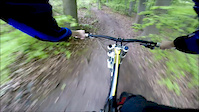
The trails consists of three sections. The first, and shortest one, is rooty with occassional small gap jumps. It ends at a gravel road crossing where hikers may walk along. This part ends with a wooden barrier where riders have to slow down to pass.

The second section has more roots, a small stone drop and gap jumps. It ends on an access road which transitions into the third and last section.

The third section is very flowy and has many tabletop jumps and the occasional gap jump. Near the end is a stone drop that leads into berms.

All features on this trail have chicken runs. Even the first rooty part on the second section can be bypassed. Gap jumps are often marked, but not all of them.

Trail Supporters
  • Region Hannover
    Sponsor
  • Deisterfreun.de e.V.
    Builder
  • Deisterfreun.de e.V.
    Maintainer
  • Niedersächsische Landesforsten
    Land Manager
Local Trail Association

Recent Activity on Trail

Past Week
  • 0 rides
  •  
6 Months
  • 14 rides
  • 23.6 km avg distance
All
  • 306 rides
  • Last: Jun 20, 2026
c1c2c3c4
January
February
March
April
May
June
July
August
September
October
November
December
update trails status or condition

Ü30 Trail Reports

Status:
on Jul 26, 2025
Ideal
Avg: 4.55 (21 votes)
Your vote: 0

view (2,225)
close
3D
Trail Conditions
  • Unknown
  • Snow Groomed
  • Snow Packed
  • Snow Covered
  • Snow Cover Partial
  • Freeze/thaw Cycle
  • Icy
  • Prevalent Mud
  • Wet
  • Variable
  • Ideal
  • Dry
  • Very Dry
Trail Flow (Ridden Direction)
Trailforks scans users ridelogs to determine the most popular direction each trail is ridden. A good flowing trail network will have most trails flowing in a single direction according to their intension.
The colour categories are based on what percentage of riders are riding a trail in its intended direction.
  • > 96%
  • > 90%
  • > 80%
  • > 70%
  • > 50%
  • < 50%
  • bi-directional trail
  • no data
Trail Last Ridden
Trailforks scans ridelogs to determine the last time a trail was ridden.
  • < 2 days
  • < 1 week
  • < 2 weeks
  • < 1 month
  • < 6 months
  • > 6 months
Trail Ridden Direction
The intended direction a trail should be ridden.
  • Downhill Only
  • Downhill Primary
  • Both Directions
  • Uphill Primary
  • Uphill Only
  • One Direction
Contribute Details
Colors indicate trail is missing specified detail.
  • Description
  • Photos
  • Description & Photos
  • Videos
Trail Popularity ?
Trailforks scans ridelogs to determine which trails are ridden the most in the last 9 months. Trails are compared with nearby trails in the same city region with a possible 25 colour shades. Think of this as a heatmap, more rides = more kinetic energy = warmer colors.
  • most popular
  • popular
  • less popular
  • not popular
ATV/ORV/OHV Filter
Max Vehicle Width
inches
US Cell Coverage
Legend
cell carrier legend

Radar Time
Activity Recordings
Trailforks uses anonymized public activity data. ?
Activity Recordings
Trailforks uses anonymized public activity data. ?
Personal Heatmap
Activity Types
all / none
Options
2
Date range month
Winter Trails
Warning A routing network for winter maps does not exist. Selecting trails using the winter trails layer has been disabled.
Missing Trails
Most Popular
Least Popular
Trails are colored based on popularity. The more popular a trail is, the more red. Less popular trails trend towards green.
Jump Magnitude Heatmap
Heatmap of where riders jump on trails. Zoom in to see individual jumps, click circles to view jump details.
BC Backroad Status

Service Road Atlas is a free to use, community-driven service for viewing and creating reports on the numerous back-country service roads around B.C. and Alberta.

map legend
Slope Aspect
Direction the slope faces
Flat N NE E SE S SW W NW
Trails Deemphasized
Trails are shown in grey.
disable
Only show trails with no bike usage.
Enable
Suggested Layers
Based on selected activity type

    Save the current map location and zoom level as your default home location whenever this page is loaded.

    Save
        Directions to u30 trailhead (52.260590, 9.481220)

        Photos

        21 more »
        46 |
        Apr 10, 2025 @ 11:53am
        Apr 10, 2025
        236 |
        Sep 9, 2019 @ 5:13am
        Sep 9, 2019
        229 |
        Apr 2, 2019 @ 4:41am
        Apr 2, 2019
        223 |
        Apr 2, 2019 @ 4:41am
        Apr 2, 2019

        Videos

        4 more »
        Ü30 | TRAIL PREVIEW | Hannover, Germany ,...
        5:30 | 308 | Mar 12, 2024 , Bad Münder am Deister
        Deister Ü30 // GoPro run 2016
        8:15 | 468 | Nov 4, 2016 , Bad Münder am Deister
        Deister Ü30 Freeride // GoPro Run 2015
        2:57 | 362 | Dec 7, 2015 , Bad Münder am Deister
        Deister Ü30 Downhillpart
        3:39 | 267 | Jul 15, 2013 , Bad Münder am Deister

        4 Reviews & Comments


        We hope you've been enjoying Trailforks!

        Create a FREE account to view trail comments and much more.

        • By timjue & contributors
        • #34035 - 7,285 views

        Frequently Asked Questions About Ü30

        Where is Ü30 located?
        Ü30 is located in Deister (Hannover), Bad Münder am Deister, Germany. It is part of the Deister (Hannover) trail network. The trailhead is located at coordinates 52.26059, 9.48122.
        How hard is Ü30?
        Ü30 is rated as Green difficulty. The physical rating is Moderate. The average grade is 7.5%.
        What is the elevation gain for Ü30?
        The trail has 181 m of elevation descent. The elevation ranges from 162 m to 343 m.
        How long is Ü30?
        Ü30 is 2.4 km long. The trail type is singletrack.

        Hit the Trail

        Open in App

        Get this trail on your phone instantly.
        open trail in app

        Download Trail

        Save to wishlist, Garmin & download.
        save the trail

        Find Related Routes

        Find routes and users activities that include this trail.
        find routes for this trail

        You must enter a description before submitting.