more stats
2,471 ft
Distance
7 ft
Climb
-451 ft
Descent
00:03:50
Avg time
-445 ft
Altitude change
740 ft
Altitude min
1,184 ft
Altitude max
1,184 ft
Altitude start
740 ft
Altitude end
-17.994%
Grade
-39.249%
Grade max
4.861%
Grade min
91 ft
Distance climb
2,184 ft
Distance down
196 ft
Distance flat
00:03:50
Avg time

Umus Details

  • Activities
    • Mountain Bike
    • E-Bike
    • Hike
    • Trail Running
  • Riding Area
    Mandaro trail zone
    Reggio Emilia
  • Difficulty Rating
  • Local Popularity
    55 in Mountain Biking [+]
    • 70 in E-Biking
    • 5 in Trail Running
    • 5 in Hiking
  • Global Ranking
    #105162 in Mountain Biking [+]
    • #47708 in E-Biking
    • #131367 in Trail Running
    • #124500 in Hiking
  • Trail Type
    Singletrack
  • Bike Type
    DH, AM
  • Direction
    Downhill Primary
    Popular Direction Shown
  • Dogs Allowed
    Yes
  • eBike Allowed
    Yes up to Class 1
  • TTFs on Trail
    Drop, Jump

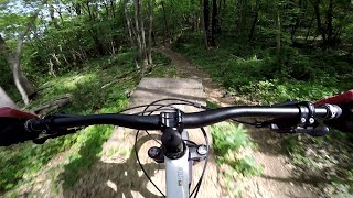
Il trail si snoda principalmente sottobosco, bel singletrack scorrevole e divertente senza particolari pendenze e difficolta

Access Info

quando si sale per il trasferimento sul monte Corniola si possono vedere i cartelli che indicano i vari trail, è possibile percorrere il trail genesi al termine del quale partono Anello e Umus, oppure volendo si puo accedere direttamente senza passare da genesi.

Recent Activity on Trail

Past Week
  • 0 rides
  •  
6 Months
  • 1 rides
  • 23 miles avg distance
All
  • 16 rides
  • Last: Jun 6, 2026
c1c2c3c4
January
February
March
April
May
June
July
August
September
October
November
December
update trails status or condition

Umus Trail Reports

statusdatedescription
Jun 4, 2026 @ 6:35pm (Europe/San_Marino)
Jun 4, 2026
May 3, 2026 @ 9:47am (Europe/Rome)
May 3, 2026
Jun 3, 2025 @ 12:49am
Jun 3, 2025
Apr 28, 2023 @ 8:28am
Apr 28, 2023
Apr 12, 2023 @ 6:45pm
Apr 12, 2023
Asciutto ma alcuni tratti sono scavati dai passaggi fatti con fango. In generale secco con un paio di ristagni.
more »
Status:
on Jun 4, 2026
Ideal
Avg: 3.98 (1 votes)
Your vote: 0

view (394)
close
3D
Trail Conditions
  • Unknown
  • Snow Groomed
  • Snow Packed
  • Snow Covered
  • Snow Cover Partial
  • Freeze/thaw Cycle
  • Icy
  • Prevalent Mud
  • Wet
  • Variable
  • Ideal
  • Dry
  • Very Dry
Trail Flow (Ridden Direction)
Trailforks scans users ridelogs to determine the most popular direction each trail is ridden. A good flowing trail network will have most trails flowing in a single direction according to their intension.
The colour categories are based on what percentage of riders are riding a trail in its intended direction.
  • > 96%
  • > 90%
  • > 80%
  • > 70%
  • > 50%
  • < 50%
  • bi-directional trail
  • no data
Trail Last Ridden
Trailforks scans ridelogs to determine the last time a trail was ridden.
  • < 2 days
  • < 1 week
  • < 2 weeks
  • < 1 month
  • < 6 months
  • > 6 months
Trail Ridden Direction
The intended direction a trail should be ridden.
  • Downhill Only
  • Downhill Primary
  • Both Directions
  • Uphill Primary
  • Uphill Only
  • One Direction
Contribute Details
Colors indicate trail is missing specified detail.
  • Description
  • Photos
  • Description & Photos
  • Videos
Trail Popularity ?
Trailforks scans ridelogs to determine which trails are ridden the most in the last 9 months. Trails are compared with nearby trails in the same city region with a possible 25 colour shades. Think of this as a heatmap, more rides = more kinetic energy = warmer colors.
  • most popular
  • popular
  • less popular
  • not popular
ATV/ORV/OHV Filter
Max Vehicle Width
inches
US Cell Coverage
Legend
cell carrier legend

Radar Time
Activity Recordings
Trailforks uses anonymized public activity data. ?
Activity Recordings
Trailforks uses anonymized public activity data. ?
Personal Heatmap
Activity Types
all / none
Options
2
Date range month
Winter Trails
Warning A routing network for winter maps does not exist. Selecting trails using the winter trails layer has been disabled.
Missing Trails
Most Popular
Least Popular
Trails are colored based on popularity. The more popular a trail is, the more red. Less popular trails trend towards green.
Jump Magnitude Heatmap
Heatmap of where riders jump on trails. Zoom in to see individual jumps, click circles to view jump details.
BC Backroad Status

Service Road Atlas is a free to use, community-driven service for viewing and creating reports on the numerous back-country service roads around B.C. and Alberta.

map legend
Slope Aspect
Direction the slope faces
Flat N NE E SE S SW W NW
Trails Deemphasized
Trails are shown in grey.
disable
Only show trails with no bike usage.
Enable
Suggested Layers
Based on selected activity type

    Save the current map location and zoom level as your default home location whenever this page is loaded.

    Save
        Directions to umus trailhead (44.601740, 10.495810)

        Photos

        2 more »
        44 |
        Oct 10, 2021 @ 11:34am
        Oct 10, 2021
        61 |
        Apr 10, 2021 @ 2:58pm
        Apr 10, 2021

        Videos

        2 more »
        Umus dal Genesi 2023 - Mandaro Trail Zone -...
        3:57 | 138 | Apr 28, 2023 , Reggio Emilia
        trail umus
        3:58 | 158 | Jun 7, 2017 , Reggio Emilia

        Reviews / Comments

        No reviews yet, be the first to write a review or ask a question.
        Use trail reports to comment on trail conditions.


        We hope you've been enjoying Trailforks!

        Create a FREE account to view trail comments and much more.

        • By andreabraglia & contributors
        • #66581 - 2,462 views

        Frequently Asked Questions About Umus

        Where is Umus located?
        Umus is located in Mandaro trail zone, Reggio Emilia, Italy. It is part of the Mandaro trail zone trail network. The trailhead is located at coordinates 44.60174, 10.49581.
        How hard is Umus?
        Umus is rated as Blue difficulty. The average grade is 17.994%.
        What is the elevation gain for Umus?
        Umus has 2 m of elevation gain. The trail has 138 m of elevation descent. The elevation ranges from 225 m to 361 m.
        Is Umus a point to point trail?
        Umus is not a point to point trail. The direction is Downhill Primary. The trail type is singletrack.

        Hit the Trail

        Open in App

        Get this trail on your phone instantly.
        open trail in app

        Download Trail

        Save to wishlist, Garmin & download.
        save the trail

        Find Related Routes

        Find routes and users activities that include this trail.
        find routes for this trail

        You must enter a description before submitting.