more stats
2,720 ft
Distance
11 ft
Climb
-267 ft
Descent
00:17:11
Avg time
-256 ft
Altitude change
317 ft
Altitude min
574 ft
Altitude max
574 ft
Altitude start
318 ft
Altitude end
-9.4%
Grade
-54.6%
Grade max
9.9%
Grade min
220 ft
Distance climb
2,283 ft
Distance down
171 ft
Distance flat
00:17:11
Avg time

Uncle Peter DH Details

  • Activities
    • Mountain Bike
  • Riding Area
    Cascades
    Sydney
  • AKA
    Petes
  • Difficulty Rating
  • Voted Difficulty
    Secondary Access Road/Trail (6 votes)
  • Local Popularity
    35 in Mountain Biking
  • Global Ranking
    #91164 in Mountain Biking
  • Trail Type
    Singletrack
  • Bike Type
    DH, AM
  • Direction
    Downhill Only
  • Physical Rating
    Moderate
  • Trail Visibility
    Always easy to follow
  • Season
    Jan-Dec
  • eBike Allowed
    Yes up to Class 1
  • TTFs on Trail
    Berm, Bridge, Drop, Jump, Gap Jump, Ladder Bridge, Rock Face, Rock Garden, Other
  • Year Opened
    2019

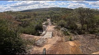
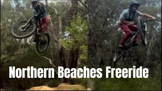
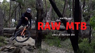
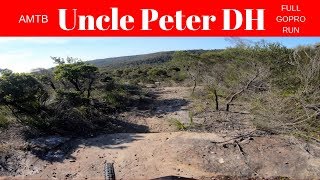
Freeride track with lots of jumps and drops. In lots of areas, there is B-Lines however in multiple areas there is not and the A-line must be done. This is a double black track when doing all the A-Lines however it would become Black with the B-Lines. If you want to experience some air time this is the track you want to ride.

Access Info

Turn off Ralston Avenue Trail onto the track and it finishes on the Heath Track to climb out off.

This trail is unsanctioned.

Disclaimer

Do not ride in the wet

Traditionally Indigenous Territory

Recent Activity on Trail

Past Week
  • 0 rides
  •  
6 Months
  • 1 rides
  • 7 miles avg distance
All
  • 37 rides
  • Last: Feb 7, 2026
c1c2c3c4
January
February
March
April
May
June
July
August
September
October
November
December
update trails status or condition

Uncle Peter DH Trail Reports

statusdatedescription
Jun 11, 2025 @ 6:58am
Jun 11, 2025
creek line has had a freshen up, few new side hits. We've noticed that other builders have been putting case pads on the landings of some jumps....
Sep 9, 2024 @ 4:49pm
Sep 9, 2024
Aug 21, 2024 @ 7:18pm
Aug 21, 2024
Some rock work has been done to the entry of second sister, track is running prime overall.
Aug 16, 2024 @ 6:25am
Aug 16, 2024
All main sections of the track has been given a fresh sweep and broom this afternoon and is looking prime for the weekend
Jul 24, 2024 @ 2:02am
Jul 24, 2024
Track has had some time to set and dry, most features have been given a rebuild and are running well. Everything up until the step up is running
more »
Status:
on Jun 11, 2025
Ideal
Avg: 4.22 (7 votes)
Your vote: 0

view (456)
close
3D
Trail Conditions
  • Unknown
  • Snow Groomed
  • Snow Packed
  • Snow Covered
  • Snow Cover Partial
  • Freeze/thaw Cycle
  • Icy
  • Prevalent Mud
  • Wet
  • Variable
  • Ideal
  • Dry
  • Very Dry
Trail Flow (Ridden Direction)
Trailforks scans users ridelogs to determine the most popular direction each trail is ridden. A good flowing trail network will have most trails flowing in a single direction according to their intension.
The colour categories are based on what percentage of riders are riding a trail in its intended direction.
  • > 96%
  • > 90%
  • > 80%
  • > 70%
  • > 50%
  • < 50%
  • bi-directional trail
  • no data
Trail Last Ridden
Trailforks scans ridelogs to determine the last time a trail was ridden.
  • < 2 days
  • < 1 week
  • < 2 weeks
  • < 1 month
  • < 6 months
  • > 6 months
Trail Ridden Direction
The intended direction a trail should be ridden.
  • Downhill Only
  • Downhill Primary
  • Both Directions
  • Uphill Primary
  • Uphill Only
  • One Direction
Contribute Details
Colors indicate trail is missing specified detail.
  • Description
  • Photos
  • Description & Photos
  • Videos
Trail Popularity ?
Trailforks scans ridelogs to determine which trails are ridden the most in the last 9 months. Trails are compared with nearby trails in the same city region with a possible 25 colour shades. Think of this as a heatmap, more rides = more kinetic energy = warmer colors.
  • most popular
  • popular
  • less popular
  • not popular
ATV/ORV/OHV Filter
Max Vehicle Width
inches
US Cell Coverage
Legend
cell carrier legend

Radar Time
Activity Recordings
Trailforks uses anonymized public activity data. ?
Activity Recordings
Trailforks uses anonymized public activity data. ?
Personal Heatmap
Activity Types
all / none
Options
2
Date range month
Winter Trails
Warning A routing network for winter maps does not exist. Selecting trails using the winter trails layer has been disabled.
Missing Trails
Most Popular
Least Popular
Trails are colored based on popularity. The more popular a trail is, the more red. Less popular trails trend towards green.
Jump Magnitude Heatmap
Heatmap of where riders jump on trails. Zoom in to see individual jumps, click circles to view jump details.
BC Backroad Status

Service Road Atlas is a free to use, community-driven service for viewing and creating reports on the numerous back-country service roads around B.C. and Alberta.

map legend
Slope Aspect
Direction the slope faces
Flat N NE E SE S SW W NW
Trails Deemphasized
Trails are shown in grey.
disable
Only show trails with no bike usage.
Enable
Suggested Layers
Based on selected activity type

    Save the current map location and zoom level as your default home location whenever this page is loaded.

    Save
        Directions to uncle-peter-dh trailhead (-33.725590, 151.204730)

        Photos

        89 more »
        82 |
        Jun 11, 2024 @ 5:30am
        Jun 11, 2024
        75 |
        Jun 11, 2024 @ 5:30am
        Jun 11, 2024
        69 |
        Jun 11, 2024 @ 5:30am
        Jun 11, 2024
        102 |
        Jun 11, 2024 @ 5:30am
        Jun 11, 2024

        Videos

        5 more »
        Uncle Petes DH - GoPro Hero 11 2024
        2:04 | 485 | Sep 3, 2024 , Sydney
        Local Feeride / Uncle Peter DH and Oxi...
        8:32 | 156 | Jul 30, 2024 , Sydney
        Uncle Peter DH - RAW VIDEO
        0:47 | 1625 | Aug 9, 2020 , Sydney
        Uncle Peter DH || Sydney, Australia || Full...
        0:56 | 2095 | Apr 5, 2020 , Sydney

        Routes with this trail

        11 miles 1,223 ft 7
        Mix of tracks in Davidson, Terry hills and finishing up with

        7 Reviews & Comments


        We hope you've been enjoying Trailforks!

        Create a FREE account to view trail comments and much more.

        • #270433 - 8,329 views

        Frequently Asked Questions About Uncle Peter DH

        Where is Uncle Peter DH located?
        Uncle Peter DH is located in Cascades, Sydney, Australia. It is part of the Cascades trail network. The trailhead is located at coordinates -33.72559, 151.20473.
        How hard is Uncle Peter DH?
        Uncle Peter DH is rated as Proline difficulty. The physical rating is Moderate. The average grade is 9.4%.
        What is the elevation gain for Uncle Peter DH?
        Uncle Peter DH has 4 m of elevation gain. The trail has 82 m of elevation descent. The elevation ranges from 97 m to 175 m.
        Is Uncle Peter DH a point to point trail?
        Yes, Uncle Peter DH is a point to point trail. The direction is Downhill Only. The trail type is singletrack.

        Hit the Trail

        Open in App

        Get this trail on your phone instantly.
        open trail in app

        Download Trail

        Save to wishlist, Garmin & download.
        save the trail

        Find Related Routes

        Find routes and users activities that include this trail.
        find routes for this trail

        You must enter a description before submitting.