This trail is permanently closed/decommissioned
more stats
2,792 ft
Distance
280 ft
Climb
-32 ft
Descent
00:07:57
Avg time
248 ft
Altitude change
1,466 ft
Altitude min
1,731 ft
Altitude max
1,467 ft
Altitude start
1,716 ft
Altitude end
8.9%
Grade
-32%
Grade max
42.4%
Grade min
1,988 ft
Distance climb
420 ft
Distance down
384 ft
Distance flat
00:07:57
Avg time

Up DJ Details

  • Activities
    • Mountain Bike
    • E-Bike
    • Hike
    • Trail Running
  • Riding Area
  • Difficulty Rating
  • Voted Difficulty
    Blue (1 vote)
  • Local Popularity
    85 in Mountain Biking [+]
    • 100 in E-Biking
    • 70 in Trail Running
    • 95 in Hiking
  • Global Ranking
    #886 in Mountain Biking [+]
    • #2117 in E-Biking
    • #82195 in Trail Running
    • #1995 in Hiking
  • Trail Type
    Machine Groomed
  • Bike Type
    AM, XC
  • Climb Difficulty
    Blue
  • Physical Rating
    Moderate
  • Trail Visibility
    Always easy to follow
  • eBike Allowed
  • TTFs on Trail
    Berm, Roller Coaster
  • Year Opened
    2015
  • Land Owner
    Hancock Victorian Plantations

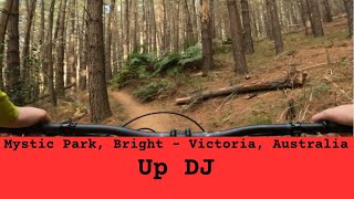
Up DJ is a smooth, flowing climbing trail that gives you great access to a bunch of Mystic MTB Parks mid mountain descents. Feel like climbing still? Head up.
Hades, it'll take you right to the top of Hero trail.
History of Up DJ - This epic climbing trail was the brainchild of two local trail builders Dan and Jimmy - hence the name Up DJ (Nothing to do with DJing). Dan and Jimmy were sick of riding up the dusty road to access trails, and this is where the journey begun. Dan and Jimmy designed the entire trail in 2015 and with the help of Steve Bryan(Bright Trails) on the digger, this masterpiece was created over 6 months. A number of other locals pitched in to lend a hand too (Phil, Matt, Dave, and other ACC club members). This trail was 100% donated and completely free.

Trail Supporters

Bike Park

Local Trail Association
Traditionally Indigenous Territory

Recent Activity on Trail

Past Week
  • 0 rides
  •  
6 Months
  • 43 rides
  • 11 miles avg distance
All
  • 1,328 rides
  • Last: Apr 27, 2019
c1c2c3c4
January
February
March
April
May
June
July
August
September
October
November
December
update trails status or condition

Up DJ Trail Reports

statusdatedescription
Jan 27, 2026 @ 10:45am (Australia/Melbourne)
Jan 26, 2026
Closed due to harvest. Visit our website for more information: https://www.elevationmystic.com/media/harvesting-oct25/
Dec 24, 2025 @ 9:41am (Australia/Melbourne)
Dec 23, 2025
Trail is temporarily open for Dec/Jan season
Oct 6, 2025 @ 11:37am (Australia/Melbourne)
Oct 5, 2025
Permanently closed due to harvesting.
Sep 25, 2025 @ 11:09am (Australia/Melbourne)
Sep 24, 2025
Top notch
Sep 13, 2025 @ 7:59am (Australia/Melbourne)
Sep 12, 2025
more »
Status:
on Jan 27, 2026
Wet
Avg: 4.28 (19 votes)
Your vote: 0

view (16,352)
close
3D
Trail Conditions
  • Unknown
  • Snow Groomed
  • Snow Packed
  • Snow Covered
  • Snow Cover Partial
  • Freeze/thaw Cycle
  • Icy
  • Prevalent Mud
  • Wet
  • Variable
  • Ideal
  • Dry
  • Very Dry
Trail Flow (Ridden Direction)
Trailforks scans users ridelogs to determine the most popular direction each trail is ridden. A good flowing trail network will have most trails flowing in a single direction according to their intension.
The colour categories are based on what percentage of riders are riding a trail in its intended direction.
  • > 96%
  • > 90%
  • > 80%
  • > 70%
  • > 50%
  • < 50%
  • bi-directional trail
  • no data
Trail Last Ridden
Trailforks scans ridelogs to determine the last time a trail was ridden.
  • < 2 days
  • < 1 week
  • < 2 weeks
  • < 1 month
  • < 6 months
  • > 6 months
Trail Ridden Direction
The intended direction a trail should be ridden.
  • Downhill Only
  • Downhill Primary
  • Both Directions
  • Uphill Primary
  • Uphill Only
  • One Direction
Contribute Details
Colors indicate trail is missing specified detail.
  • Description
  • Photos
  • Description & Photos
  • Videos
Trail Popularity ?
Trailforks scans ridelogs to determine which trails are ridden the most in the last 9 months. Trails are compared with nearby trails in the same city region with a possible 25 colour shades. Think of this as a heatmap, more rides = more kinetic energy = warmer colors.
  • most popular
  • popular
  • less popular
  • not popular
ATV/ORV/OHV Filter
Max Vehicle Width
inches
US Cell Coverage
Legend
cell carrier legend

Radar Time
Activity Recordings
Trailforks uses anonymized public activity data. ?
Activity Recordings
Trailforks uses anonymized public activity data. ?
Personal Heatmap
Activity Types
all / none
Options
2
Date range month
Winter Trails
Warning A routing network for winter maps does not exist. Selecting trails using the winter trails layer has been disabled.
Missing Trails
Most Popular
Least Popular
Trails are colored based on popularity. The more popular a trail is, the more red. Less popular trails trend towards green.
Jump Magnitude Heatmap
Heatmap of where riders jump on trails. Zoom in to see individual jumps, click circles to view jump details.
BC Backroad Status

Service Road Atlas is a free to use, community-driven service for viewing and creating reports on the numerous back-country service roads around B.C. and Alberta.

map legend
Slope Aspect
Direction the slope faces
Flat N NE E SE S SW W NW
Trails Deemphasized
Trails are shown in grey.
disable
Only show trails with no bike usage.
Enable
Suggested Layers
Based on selected activity type

    Save the current map location and zoom level as your default home location whenever this page is loaded.

    Save
        Directions to up-dj trailhead (-36.750220, 146.966730)

        Photos

        75 more »
        114 |
        Dec 21, 2020 @ 1:09am
        Dec 21, 2020
        26 |
        Feb 5, 2024 @ 12:55pm
        Feb 5, 2024
        92 |
        Dec 21, 2020 @ 1:09am
        Dec 21, 2020
        65 |
        Jan 27, 2020 @ 1:03pm
        Jan 27, 2020

        Videos

        2 more »
        youtuber Mystic Park - Up DJ #11
        8:37 | 33 | Sep 13, 2025 , Bright
        Mystic Mountain Bike Park with Hero Trail in...
        10:18 | 1487 | Sep 27, 2019 , Bright

        Routes with this trail

        3.0 6 miles 1,105 ft 8 Loop
        A popular intermediate loop ride that takes in some of Mystic's most fun flow trails: Trail and . Follow...
        2.0 8 miles 1,480 ft 13 Loop
        24 Carat is a long and varied loop that takes in a bit of everything Mystic has to offer. The descent has...
        15 miles 2,958 ft 56 Out & Back Race
        THULE B24 GE (trad) 2017 - 4 stages, practice saturday 12pm-9pm, race sunday 7am-12pm

        1 Review & Comments


        We hope you've been enjoying Trailforks!

        Create a FREE account to view trail comments and much more.

        • By DanMillarTF Pro & contributors
        • #87917 - 5,315 views

        Frequently Asked Questions About Up DJ

        Where is Up DJ located?
        Up DJ is located in Mystic Bike Park, Bright, Australia. It is part of the Mystic Bike Park trail network. The trailhead is located at coordinates -36.75022, 146.96673.
        How hard is Up DJ?
        Up DJ is rated as Blue difficulty. The physical rating is Moderate. The average grade is 8.9%. The climb difficulty is rated Blue.
        What is the elevation gain for Up DJ?
        Up DJ has 85 m of elevation gain. The trail has 10 m of elevation descent. The elevation ranges from 447 m to 528 m.
        How long is Up DJ?
        Up DJ is 851.0 m long. The trail type is machine groomed.

        Hit the Trail

        Open in App

        Get this trail on your phone instantly.
        open trail in app

        Download Trail

        Save to wishlist, Garmin & download.
        save the trail

        Find Related Routes

        Find routes and users activities that include this trail.
        find routes for this trail

        You must enter a description before submitting.