more stats
2.2 miles
Distance
118 ft
Climb
-438 ft
Descent
00:20:37
Avg time
-320 ft
Altitude change
8,312 ft
Altitude min
8,686 ft
Altitude max
8,632 ft
Altitude start
8,310 ft
Altitude end
-2.8%
Grade
-28%
Grade max
15.6%
Grade min
3,064 ft
Distance climb
1 mile
Distance down
1,598 ft
Distance flat
00:20:37
Avg time

Upper Brookbank Details

  • Activities
    • Mountain Bike
    • Horse
    • Hike
    • Trail Running
  • Riding Area
    MEDL (Mount Elden Dry Lakes)
    Flagstaff, Arizona
  • Ref Number
    #2
  • Difficulty Rating
  • Voted Difficulty
    Blue (2 votes)
  • Local Popularity
    95 in Mountain Biking [+]
    • 85 in Trail Running
    • 75 in Hiking
    • 5 in Horseback
  • Global Ranking
    #5917 in Mountain Biking [+]
    • #48855 in Trail Running
    • #72484 in Hiking
    • #749 in Horseback
  • Hiking SAC Scale
    T2 Mountain Hiking
  • Trail Type
    Singletrack
  • Bike Type
    XC
  • Direction
    Downhill Primary
    Popular Direction Shown
  • Climb Difficulty
    Blue
  • Physical Rating
    Moderate
  • Trail Visibility
    Always easy to follow
  • Dogs Allowed
    Yes
  • TTFs on Trail
    Rock Garden

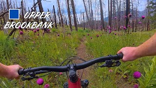
From east to west it is a mellow uphill climb to a short fun downhill followed by some fun hillside riding for a while. Fast and fun trail to access the more options. Uphill direction is harder but doable. Was closed for a year due to the Museum Fire but reopened July 29, 2020. Part of the trail in the burn scar was rerouted in August 2023.

Disclaimer

Trail may have hazards caused by the Museum Fire, ride with caution.

Trail Supporters

  • USFS
    Land Manager
Local Trail Association

Recent Activity on Trail

Past Week
  • 2 rides
  • 21 miles average
6 Months
  • 62 rides
  • 19 miles avg distance
All
  • 409 rides
  • Last: Jun 23, 2026
c1c2c3c4
January
February
March
April
May
June
July
August
September
October
November
December
update trails status or condition

Upper Brookbank Trail Reports

statusdatedescription
Jun 10, 2026 @ 1:33pm (America/Phoenix)
Jun 10, 2026
Jun 10, 2026 @ 10:18am (America/Phoenix)
Jun 10, 2026
Jun 3, 2026 @ 11:51am (America/Phoenix)
Jun 3, 2026
reporter the herbicide Millstonefoliar is being sprayed on scotch and bull thistle. expect to see crews in the area including on Big Bang, Broadside, and...
May 18, 2026 @ 1:38pm (America/Phoenix)
May 18, 2026
Multiple massive trees down about 1/2 way in
Mar 23, 2026 @ 6:21am (America/Phoenix)
Mar 23, 2026
Downed trees have been cleared.
more »
Status:
on Jun 10, 2026
Ideal
Avg: 4.4 (19 votes)
Your vote: 0

view (2,667)
close
3D
Trail Conditions
  • Unknown
  • Snow Groomed
  • Snow Packed
  • Snow Covered
  • Snow Cover Partial
  • Freeze/thaw Cycle
  • Icy
  • Prevalent Mud
  • Wet
  • Variable
  • Ideal
  • Dry
  • Very Dry
Trail Flow (Ridden Direction)
Trailforks scans users ridelogs to determine the most popular direction each trail is ridden. A good flowing trail network will have most trails flowing in a single direction according to their intension.
The colour categories are based on what percentage of riders are riding a trail in its intended direction.
  • > 96%
  • > 90%
  • > 80%
  • > 70%
  • > 50%
  • < 50%
  • bi-directional trail
  • no data
Trail Last Ridden
Trailforks scans ridelogs to determine the last time a trail was ridden.
  • < 2 days
  • < 1 week
  • < 2 weeks
  • < 1 month
  • < 6 months
  • > 6 months
Trail Ridden Direction
The intended direction a trail should be ridden.
  • Downhill Only
  • Downhill Primary
  • Both Directions
  • Uphill Primary
  • Uphill Only
  • One Direction
Contribute Details
Colors indicate trail is missing specified detail.
  • Description
  • Photos
  • Description & Photos
  • Videos
Trail Popularity ?
Trailforks scans ridelogs to determine which trails are ridden the most in the last 9 months. Trails are compared with nearby trails in the same city region with a possible 25 colour shades. Think of this as a heatmap, more rides = more kinetic energy = warmer colors.
  • most popular
  • popular
  • less popular
  • not popular
ATV/ORV/OHV Filter
Max Vehicle Width
inches
US Cell Coverage
Legend
cell carrier legend

Radar Time
Activity Recordings
Trailforks uses anonymized public activity data. ?
Activity Recordings
Trailforks uses anonymized public activity data. ?
Personal Heatmap
Activity Types
all / none
Options
2
Date range month
Winter Trails
Warning A routing network for winter maps does not exist. Selecting trails using the winter trails layer has been disabled.
Missing Trails
Most Popular
Least Popular
Trails are colored based on popularity. The more popular a trail is, the more red. Less popular trails trend towards green.
Jump Magnitude Heatmap
Heatmap of where riders jump on trails. Zoom in to see individual jumps, click circles to view jump details.
BC Backroad Status

Service Road Atlas is a free to use, community-driven service for viewing and creating reports on the numerous back-country service roads around B.C. and Alberta.

map legend
Slope Aspect
Direction the slope faces
Flat N NE E SE S SW W NW
Trails Deemphasized
Trails are shown in grey.
disable
Only show trails with no bike usage.
Enable
Suggested Layers
Based on selected activity type

    Save the current map location and zoom level as your default home location whenever this page is loaded.

    Save
        Directions to upper-brookbank trailhead (35.268230, -111.611500)

        Photos

        18 more »
        49 |
        Oct 24, 2024 @ 11:03am
        Oct 24, 2024
        40 |
        Oct 24, 2024 @ 11:02am
        Oct 24, 2024
        50 |
        Oct 24, 2024 @ 11:02am
        Oct 24, 2024
        41 |
        Oct 24, 2024 @ 11:02am
        Oct 24, 2024

        Videos

        1 more »
        Flagstaff Trail Guide: Upper Brookbank
        8:35 | 95 | Aug 22, 2025 , Flagstaff

        Routes with this trail

        28 miles 4,115 ft 10
        https://rockyroad5050.wordpress.com/5-aspen-asphyxiation/
        3.0 16 miles 1,947 ft 34 Loop
        Nice loop starting/finishing at trailhead (top of ).
        1.0 16 miles 1,115 ft 15 Shuttled
        From the lookout towers on Mt. Elden to .

        4 Reviews & Comments


        We hope you've been enjoying Trailforks!

        Create a FREE account to view trail comments and much more.

        • By toddTF Pro Trailforks & contributors
        • #16345 - 4,483 views

        Frequently Asked Questions About Upper Brookbank

        Where is Upper Brookbank located?
        Upper Brookbank is located in MEDL (Mount Elden Dry Lakes), Flagstaff, Arizona, United States. It is part of the MEDL (Mount Elden Dry Lakes) trail network. The trailhead is located at coordinates 35.26823, -111.6115.
        How hard is Upper Brookbank?
        Upper Brookbank is rated as Blue difficulty. The physical rating is Moderate. The average grade is 2.8%. The climb difficulty is rated Blue.
        What is the elevation gain for Upper Brookbank?
        Upper Brookbank has 118 ft of elevation gain. The trail has 438 ft of elevation descent. The elevation ranges from 8,312 ft to 8,686 ft.
        Is Upper Brookbank a point to point trail?
        Upper Brookbank is not a point to point trail. The direction is Downhill Primary. The trail type is singletrack.

        Hit the Trail

        Open in App

        Get this trail on your phone instantly.
        open trail in app

        Download Trail

        Save to wishlist, Garmin & download.
        save the trail

        Find Related Routes

        Find routes and users activities that include this trail.
        find routes for this trail

        You must enter a description before submitting.