more stats
2.9 miles
Distance
120 ft
Climb
-3,470 ft
Descent
01:36:35
Avg time
-3,351 ft
Altitude change
4,999 ft
Altitude min
8,350 ft
Altitude max
8,350 ft
Altitude start
4,999 ft
Altitude end
-22.227%
Grade
-85.447%
Grade max
19.601%
Grade min
1,688 ft
Distance climb
2 miles
Distance down
446 ft
Distance flat
01:36:35
Avg time

Upper Della Details

  • Activities
    • Mountain Bike
    • Hike
    • Trail Running
  • Riding Area
    Lillooet
    , British Columbia
  • Difficulty Rating
  • Local Popularity
    5 in Mountain Biking [+]
    • 5 in Trail Running
    • 5 in Hiking
  • Global Ranking
    #144121 in Mountain Biking [+]
    • #137837 in Trail Running
    • #131870 in Hiking
  • Trail Type
    Singletrack
  • Bike Type
    AM
  • Direction
    Downhill Primary
  • Climb Difficulty
    Double Black Diamond
  • Physical Rating
    Extreme
  • Dogs Allowed
    Yes
  • eBike Allowed
  • TTFs on Trail
    Rock Garden

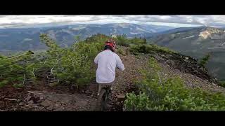
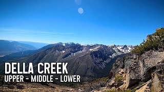
Loose, rocky, shaly single track descent from the top of Askom Mountain.
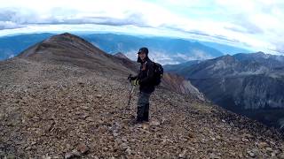
Only the most committed riders will make it up there with their bike on their back, scrambling up loose shale.
And only the most expert riders (Danny Hart sized balls) will ride back down.
Views form the top are spectacular though.

Access Info

Hike-a-bike access only by pushing up the down trail from the access road... And it goes straight up the mountain over steep, loose, shale & rocks. In sections this becomes more like bike-mountaineering. Not for the faint of heart or uncommitted.

Local Trail Association
Traditionally Indigenous Territory

Recent Activity on Trail

Past Week
  • 1 rides
  • 18.5 km average
6 Months
  • 2 rides
  • 19.5 km avg distance
All
  • 3 rides
  • Last: Jun 20, 2026
c1c2c3c4
January
February
March
April
May
June
July
August
September
October
November
December
update trails status or condition

Upper Della Trail Reports

statusdatedescription
Jun 16, 2026 @ 8:18am (America/Vancouver)
Jun 16, 2026
Running great, no snow up top and about 7 trees down very low on the trail
Sep 16, 2024 @ 4:54pm
Sep 16, 2024
Couple trees down that you can't ride over.
Sep 22, 2023 @ 9:59pm
Sep 22, 2023
4 downed trees, all within 50m of each other
Sep 13, 2021 @ 10:31am
Sep 13, 2021
As the below report, 2 downed trees but easily spotted. Only got to the start of the climb/scramble up to the top ridge line, below that the trail...
Aug 2, 2019 @ 1:36am
Aug 2, 2019
went up a couple weeks ago, trail portion only had 2 downed trees and you could go under one and over the other. so it must of been cleared...
more »
Status:
on Jun 16, 2026
Dry
Avg: 4.21 (3 votes)
Your vote: 0

view (26)
close
3D
Trail Conditions
  • Unknown
  • Snow Groomed
  • Snow Packed
  • Snow Covered
  • Snow Cover Partial
  • Freeze/thaw Cycle
  • Icy
  • Prevalent Mud
  • Wet
  • Variable
  • Ideal
  • Dry
  • Very Dry
Trail Flow (Ridden Direction)
Trailforks scans users ridelogs to determine the most popular direction each trail is ridden. A good flowing trail network will have most trails flowing in a single direction according to their intension.
The colour categories are based on what percentage of riders are riding a trail in its intended direction.
  • > 96%
  • > 90%
  • > 80%
  • > 70%
  • > 50%
  • < 50%
  • bi-directional trail
  • no data
Trail Last Ridden
Trailforks scans ridelogs to determine the last time a trail was ridden.
  • < 2 days
  • < 1 week
  • < 2 weeks
  • < 1 month
  • < 6 months
  • > 6 months
Trail Ridden Direction
The intended direction a trail should be ridden.
  • Downhill Only
  • Downhill Primary
  • Both Directions
  • Uphill Primary
  • Uphill Only
  • One Direction
Contribute Details
Colors indicate trail is missing specified detail.
  • Description
  • Photos
  • Description & Photos
  • Videos
Trail Popularity ?
Trailforks scans ridelogs to determine which trails are ridden the most in the last 9 months. Trails are compared with nearby trails in the same city region with a possible 25 colour shades. Think of this as a heatmap, more rides = more kinetic energy = warmer colors.
  • most popular
  • popular
  • less popular
  • not popular
ATV/ORV/OHV Filter
Max Vehicle Width
inches
US Cell Coverage
Legend
cell carrier legend

Radar Time
Activity Recordings
Trailforks uses anonymized public activity data. ?
Activity Recordings
Trailforks uses anonymized public activity data. ?
Personal Heatmap
Activity Types
all / none
Options
2
Date range month
Winter Trails
Warning A routing network for winter maps does not exist. Selecting trails using the winter trails layer has been disabled.
Missing Trails
Most Popular
Least Popular
Trails are colored based on popularity. The more popular a trail is, the more red. Less popular trails trend towards green.
Jump Magnitude Heatmap
Heatmap of where riders jump on trails. Zoom in to see individual jumps, click circles to view jump details.
BC Backroad Status

Service Road Atlas is a free to use, community-driven service for viewing and creating reports on the numerous back-country service roads around B.C. and Alberta.

map legend
Slope Aspect
Direction the slope faces
Flat N NE E SE S SW W NW
Trails Deemphasized
Trails are shown in grey.
disable
Only show trails with no bike usage.
Enable
Suggested Layers
Based on selected activity type

    Save the current map location and zoom level as your default home location whenever this page is loaded.

    Save
        Directions to upper-della trailhead (50.485897, -121.823584)

        Photos

        31 more »
        293 |
        Sep 13, 2021 @ 10:41am
        Sep 13, 2021
        382 |
        Aug 10, 2020 @ 6:51pm
        Aug 10, 2020
        234 |
        Aug 10, 2020 @ 6:50pm
        Aug 10, 2020
        248 |
        Aug 10, 2020 @ 6:50pm
        Aug 10, 2020

        Videos

        6 more »
        youtuber IS IT WORTH IT TO HIKE-A-BIKE? | Suffering to...
        33:07 | 1807 | Oct 27, 2017 , Lillooet
        Upper Della Creek
        6:02 | 64 | Aug 22, 2025 , Lillooet
        Della Creek - 10km, 1900m Descent
        21:15 | 332 | Jan 7, 2022 , Lillooet
        Upper Della from the peak of Mt Askom
        25:04 | 213 | Sep 13, 2020 , Lillooet

        1 Review & Comments


        We hope you've been enjoying Trailforks!

        Create a FREE account to view trail comments and much more.

        • By HpSauce & contributors
        • #95687 - 6,993 views

        Frequently Asked Questions About Upper Della

        Where is Upper Della located?
        Upper Della is located in Lillooet, British Columbia, Canada. It is part of the Lillooet trail network. The trailhead is located at coordinates 50.4859, -121.82358.
        How hard is Upper Della?
        Upper Della is rated as Double Black Diamond difficulty. The physical rating is Extreme. The average grade is 22.227%. The climb difficulty is rated Double Black Diamond.
        What is the elevation gain for Upper Della?
        Upper Della has 37 m of elevation gain. The trail has 1,058 m of elevation descent. The elevation ranges from 1,524 m to 2,545 m.
        Is Upper Della a point to point trail?
        Upper Della is not a point to point trail. The direction is Downhill Primary. The trail type is singletrack.

        Hit the Trail

        Open in App

        Get this trail on your phone instantly.
        open trail in app

        Download Trail

        Save to wishlist, Garmin & download.
        save the trail

        Find Related Routes

        Find routes and users activities that include this trail.
        find routes for this trail

        You must enter a description before submitting.