more stats
1.2 miles
Distance
1 ft
Climb
-1,114 ft
Descent
00:22:22
Avg time
-1,113 ft
Altitude change
2,063 ft
Altitude min
3,176 ft
Altitude max
3,176 ft
Altitude start
2,063 ft
Altitude end
-40.778%
Grade max
1.022%
Grade min
15 ft
Distance climb
1 mile
Distance down
190 ft
Distance flat
00:22:22
Avg time

Upper J-Bar Details

  • Activities
    • Mountain Bike
  • Riding Area
    Burke Mountain Resort
    East Burke, Vermont
  • Difficulty Rating
  • Voted Difficulty
    Black Diamond (4 votes)
  • Local Popularity
    25 in Mountain Biking
  • Global Ranking
    #79966 in Mountain Biking
  • Trail Type
    Singletrack
  • Bike Type
    DH, AM
  • Direction
    Downhill Only
    Popular Direction Shown
  • Dogs Allowed
    Yes
  • eBike Allowed
  • TTFs on Trail
    Rock Face
  • Land Owner

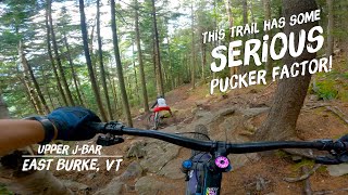
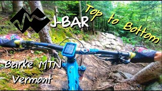
Armored banks and drops wind through winter glades on the least intimidating expert trail from the summit.

Access Info

Friday through Sunday, users will need a Q Burke Mountain Bike Park day or season pass to utilize and access Upper J Bar.

Monday - Thursday no fee required.

Traditionally Indigenous Territory

Recent Activity on Trail

Past Week
  • 0 rides
  •  
6 Months
  • 0 rides
  •  
All
  • 124 rides
  • Last: Jun 5, 2026
c1c2c3c4
January
February
March
April
May
June
July
August
September
October
November
December
Status:
on Oct 31, 2025
Avg: 4.52 (11 votes)
Your vote: 0

view (1,551)
close
3D
Trail Conditions
  • Unknown
  • Snow Groomed
  • Snow Packed
  • Snow Covered
  • Snow Cover Partial
  • Freeze/thaw Cycle
  • Icy
  • Prevalent Mud
  • Wet
  • Variable
  • Ideal
  • Dry
  • Very Dry
Trail Flow (Ridden Direction)
Trailforks scans users ridelogs to determine the most popular direction each trail is ridden. A good flowing trail network will have most trails flowing in a single direction according to their intension.
The colour categories are based on what percentage of riders are riding a trail in its intended direction.
  • > 96%
  • > 90%
  • > 80%
  • > 70%
  • > 50%
  • < 50%
  • bi-directional trail
  • no data
Trail Last Ridden
Trailforks scans ridelogs to determine the last time a trail was ridden.
  • < 2 days
  • < 1 week
  • < 2 weeks
  • < 1 month
  • < 6 months
  • > 6 months
Trail Ridden Direction
The intended direction a trail should be ridden.
  • Downhill Only
  • Downhill Primary
  • Both Directions
  • Uphill Primary
  • Uphill Only
  • One Direction
Contribute Details
Colors indicate trail is missing specified detail.
  • Description
  • Photos
  • Description & Photos
  • Videos
Trail Popularity ?
Trailforks scans ridelogs to determine which trails are ridden the most in the last 9 months. Trails are compared with nearby trails in the same city region with a possible 25 colour shades. Think of this as a heatmap, more rides = more kinetic energy = warmer colors.
  • most popular
  • popular
  • less popular
  • not popular
ATV/ORV/OHV Filter
Max Vehicle Width
inches
US Cell Coverage
Legend
cell carrier legend

Radar Time
Activity Recordings
Trailforks uses anonymized public activity data. ?
Activity Recordings
Trailforks uses anonymized public activity data. ?
Personal Heatmap
Activity Types
all / none
Options
2
Date range month
Winter Trails
Warning A routing network for winter maps does not exist. Selecting trails using the winter trails layer has been disabled.
Missing Trails
Most Popular
Least Popular
Trails are colored based on popularity. The more popular a trail is, the more red. Less popular trails trend towards green.
Jump Magnitude Heatmap
Heatmap of where riders jump on trails. Zoom in to see individual jumps, click circles to view jump details.
BC Backroad Status

Service Road Atlas is a free to use, community-driven service for viewing and creating reports on the numerous back-country service roads around B.C. and Alberta.

map legend
Slope Aspect
Direction the slope faces
Flat N NE E SE S SW W NW
Trails Deemphasized
Trails are shown in grey.
disable
Only show trails with no bike usage.
Enable
Suggested Layers
Based on selected activity type

    Save the current map location and zoom level as your default home location whenever this page is loaded.

    Save
        Directions to upper-jbar trailhead (44.570730, -71.895250)

        Photos

        16 more »
        1,315 |
        Sep 21, 2015 @ 12:43am
        Sep 21, 2015
        176 |
        Aug 14, 2021 @ 4:50pm
        Aug 14, 2021
        181 |
        Aug 14, 2021 @ 4:50pm
        Aug 14, 2021
        261 |
        Aug 10, 2019 @ 2:49pm
        Aug 10, 2019

        Videos

        6 more »
        Finding the Steeps Pt. 2: Upper J-Bar
        11:15 | 696 | Nov 18, 2022 , East Burke
        youtuber J-Bar  Burke Mtn VT | Top to Bottom | NETS...
        12:47 | 1376 | Oct 3, 2020 , East Burke
        Upper J-Bar - Burke Mountain
        0:01 | 1302 | Oct 22, 2018 , East Burke
        Best Descent in VT? | Day Two BONUS - J Bar to...
        7:31 | 731 | Oct 21, 2018 , East Burke

        Trail Lists

        Routes with this trail

        2.7 10 miles 3,300 ft 4 Loop
        I've heard a lot about the Kingdom Trails, but when I rolled into East Burke I was pretty confused as to...
        12 miles 2,531 ft 12 Loop
        This from the Tiki Bar Parking location is great for riders who want a technical, fun and physically...
        57 miles 12,505 ft 118 Loop
        We will ride for glory, freedom, and the dignity of the working man. Four laps to the top of Burke, four...

        3 Reviews & Comments


        We hope you've been enjoying Trailforks!

        Create a FREE account to view trail comments and much more.

        • By burkemountainbikepark BMBP & contributors
        • #10624 - 7,753 views

        Frequently Asked Questions About Upper J-Bar

        Where is Upper J-Bar located?
        Upper J-Bar is located in Burke Mountain Resort, East Burke, Vermont, United States. It is part of the Burke Mountain Resort trail network. The trailhead is located at coordinates 44.57073, -71.89525.
        How hard is Upper J-Bar?
        Upper J-Bar is rated as Double Black Diamond difficulty.
        What is the elevation gain for Upper J-Bar?
        Upper J-Bar has 1 ft of elevation gain. The trail has 1,114 ft of elevation descent. The elevation ranges from 2,063 ft to 3,176 ft.
        Is Upper J-Bar a point to point trail?
        Yes, Upper J-Bar is a point to point trail. The direction is Downhill Only. The trail type is singletrack.

        Hit the Trail

        Open in App

        Get this trail on your phone instantly.
        open trail in app

        Download Trail

        Save to wishlist, Garmin & download.
        save the trail

        Find Related Routes

        Find routes and users activities that include this trail.
        find routes for this trail

        You must enter a description before submitting.