more stats
1.8 miles
Distance
1,110 ft
Climb
-209 ft
Descent
00:56:10
Avg time
901 ft
Altitude change
6,670 ft
Altitude min
7,780 ft
Altitude max
6,879 ft
Altitude start
7,779 ft
Altitude end
9.7%
Grade
-23.3%
Grade max
67%
Grade min
1 mile
Distance climb
2,566 ft
Distance down
89 ft
Distance flat
00:56:10
Avg time

Upper Old Glory Trail Details

  • Activities
    • Hike
    • Mountain Bike
    • Horse
    • Trail Running
  • Riding Area
    Rossland Range
    Rossland, British Columbia
  • Difficulty Rating
  • Local Popularity
    40 in Mountain Biking [+]
    • 90 in Trail Running
    • 100 in Hiking
    • 5 in Horseback
  • Global Ranking
    #119649 in Mountain Biking [+]
    • #35653 in Trail Running
    • #3650 in Hiking
    • #11105 in Horseback
  • Hiking SAC Scale
    T2 Mountain Hiking
  • Trail Type
    Hike-a-Bike
  • Bike Type
    AM, XC
  • Direction
    Both Directions
  • Climb Difficulty
    Double Black Diamond
  • Physical Rating
    Hard
  • Trail Visibility
    Sometimes hard to follow
  • Season
    July - September
  • Alpine Trail
    Yes
  • Dogs Allowed
    Yes
  • eBike Allowed

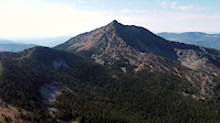
This is a Rossland Range classic trail which takes hikers to the highest summit in the Rossland Range. An old white weather station greets hikers at the top which showcases beautiful views of the region. The trail is narrow and steep in sections with some loose rock - watch your step

This is not recommended for bikes.

Access Info

Park at the Old Glory Parking Lot. Hikers have two access options :

1) Walk up the Lower Old Glory Trail and connect to the Upper Old Glory Trail via a short ridge walk up Seven Summits
2) Walk up the Plewman Trail and connect to the Upper Old Glory trail at the Seven Summits junction

Local Trail Association

Recent Activity on Trail

Past Week
  • 0 rides
  •  
6 Months
  • 0 rides
  •  
All
  • 22 rides
  • Last: Oct 3, 2025
c1c2c3c4
January
February
March
April
May
June
July
August
September
October
November
December
update trails status or condition

Upper Old Glory... Trail Reports

statusdatedescription
Jul 20, 2025 @ 1:30pm
Jul 20, 2025
Built better riding lines, rock armouring and removing pedal catching rocks.
Jul 11, 2024 @ 12:27pm
Jul 11, 2024
reporter Seasonal maintenance completed.
Oct 9, 2023 @ 11:08am
Oct 9, 2023
Jun 24, 2023 @ 8:31pm
Jun 24, 2023
Jun 22, 2023 @ 4:24pm
Jun 22, 2023
Your feet will get soaked with half a foot of snow through which you walk for about a kilometre from the summit
more »
Status:
on Jul 20, 2025
Wet
Avg: 3.65 (3 votes)
Your vote: 0

view (487)
close
3D
Trail Conditions
  • Unknown
  • Snow Groomed
  • Snow Packed
  • Snow Covered
  • Snow Cover Partial
  • Freeze/thaw Cycle
  • Icy
  • Prevalent Mud
  • Wet
  • Variable
  • Ideal
  • Dry
  • Very Dry
Trail Flow (Ridden Direction)
Trailforks scans users ridelogs to determine the most popular direction each trail is ridden. A good flowing trail network will have most trails flowing in a single direction according to their intension.
The colour categories are based on what percentage of riders are riding a trail in its intended direction.
  • > 96%
  • > 90%
  • > 80%
  • > 70%
  • > 50%
  • < 50%
  • bi-directional trail
  • no data
Trail Last Ridden
Trailforks scans ridelogs to determine the last time a trail was ridden.
  • < 2 days
  • < 1 week
  • < 2 weeks
  • < 1 month
  • < 6 months
  • > 6 months
Trail Ridden Direction
The intended direction a trail should be ridden.
  • Downhill Only
  • Downhill Primary
  • Both Directions
  • Uphill Primary
  • Uphill Only
  • One Direction
Contribute Details
Colors indicate trail is missing specified detail.
  • Description
  • Photos
  • Description & Photos
  • Videos
Trail Popularity ?
Trailforks scans ridelogs to determine which trails are ridden the most in the last 9 months. Trails are compared with nearby trails in the same city region with a possible 25 colour shades. Think of this as a heatmap, more rides = more kinetic energy = warmer colors.
  • most popular
  • popular
  • less popular
  • not popular
ATV/ORV/OHV Filter
Max Vehicle Width
inches
US Cell Coverage
Legend
cell carrier legend

Radar Time
Activity Recordings
Trailforks uses anonymized public activity data. ?
Activity Recordings
Trailforks uses anonymized public activity data. ?
Personal Heatmap
Activity Types
all / none
Options
2
Date range month
Winter Trails
Warning A routing network for winter maps does not exist. Selecting trails using the winter trails layer has been disabled.
Missing Trails
Most Popular
Least Popular
Trails are colored based on popularity. The more popular a trail is, the more red. Less popular trails trend towards green.
Jump Magnitude Heatmap
Heatmap of where riders jump on trails. Zoom in to see individual jumps, click circles to view jump details.
BC Backroad Status

Service Road Atlas is a free to use, community-driven service for viewing and creating reports on the numerous back-country service roads around B.C. and Alberta.

map legend
Slope Aspect
Direction the slope faces
Flat N NE E SE S SW W NW
Trails Deemphasized
Trails are shown in grey.
disable
Only show trails with no bike usage.
Enable
Suggested Layers
Based on selected activity type

    Save the current map location and zoom level as your default home location whenever this page is loaded.

    Save
        Directions to upper-old-glory-trail trailhead (49.150210, -117.899230)

        Photos

        20 more »
        136 |
        Nov 13, 2021 @ 5:35am
        Nov 13, 2021
        174 |
        Nov 13, 2021 @ 5:37am
        Nov 13, 2021
        112 |
        Aug 16, 2020 @ 9:35am
        Aug 16, 2020
        96 |
        Aug 16, 2020 @ 9:35am
        Aug 16, 2020

        Videos

        2 more »
        youtuber Alpine Adventure//Old Glory - Rossland, BC
        11:50 | 394 | Jul 23, 2021 , Rossland
        IS OLD GLORY THE BEST ALPINE MTB TRAIL IN CANADA?
        3:52 | 36 | Oct 12, 2023 , Rossland

        Reviews / Comments

        No reviews yet, be the first to write a review or ask a question.
        Use trail reports to comment on trail conditions.


        We hope you've been enjoying Trailforks!

        Create a FREE account to view trail comments and much more.

        • By canadakaTF Pro Trailforks & contributors
        • #2143 - 6,026 views

        Frequently Asked Questions About Upper Old Glory Trail

        Where is Upper Old Glory Trail located?
        Upper Old Glory Trail is located in Rossland Range, Rossland, British Columbia, Canada. It is part of the Rossland Range trail network. The trailhead is located at coordinates 49.15021, -117.89923.
        How hard is Upper Old Glory Trail?
        Upper Old Glory Trail is rated as Double Black Diamond difficulty. The physical rating is Hard. The average grade is 9.7%. The climb difficulty is rated Double Black Diamond.
        What is the elevation gain for Upper Old Glory Trail?
        Upper Old Glory Trail has 338 m of elevation gain. The trail has 64 m of elevation descent. The elevation ranges from 2,033 m to 2,371 m.
        Is Upper Old Glory Trail a point to point trail?
        Upper Old Glory Trail is not a point to point trail. The direction is Both Directions. The trail type is hike-a-bike.

        Hit the Trail

        Open in App

        Get this trail on your phone instantly.
        open trail in app

        Download Trail

        Save to wishlist, Garmin & download.
        save the trail

        Find Related Routes

        Find routes and users activities that include this trail.
        find routes for this trail

        You must enter a description before submitting.