more stats
1.3 miles
Distance
12 ft
Climb
-1,249 ft
Descent
00:07:11
Avg time
-1,237 ft
Altitude change
2,609 ft
Altitude min
3,845 ft
Altitude max
3,845 ft
Altitude start
2,609 ft
Altitude end
-18.149%
Grade
-37.795%
Grade max
7.436%
Grade min
246 ft
Distance climb
1 mile
Distance down
5 ft
Distance flat
00:07:11
Avg time

Upper Powderhouse Details

  • Activities
    • Mountain Bike
    • E-Bike
    • Gravel Bike
    • Adaptive Bike
    • Hike
    • Trail Running
  • Riding Area
    Mendocino National Forest
    Ukiah, California
  • Difficulty Rating
  • Local Popularity
    5 in Mountain Biking [+]
    • 75 in E-Biking
    • 5 in Trail Running
    • 5 in Hiking
  • Global Ranking
    #170149 in Mountain Biking [+]
    • #55247 in E-Biking
    • #305666 in Trail Running
    • #316532 in Hiking
  • Trail Type
    Dirt/Gravel Road
  • Bike Type
    DH, AM, Gravel, Adaptive MTB
  • Direction
    Downhill Primary
  • Dogs Allowed
    Yes
  • eBike Allowed
    Yes up to Class 1
  • TTFs on Trail
    Berm, Jump

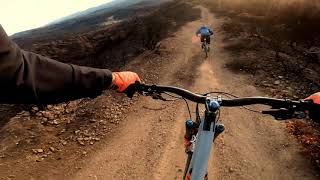
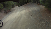
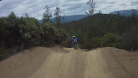
This is a high speed descent down a loose and steep jeep trail. Bring your DH or Enduro bike as there are plenty of natural hips and berms to boost off of. This trail isn't very challenging going slow, but it's easy to get up to 30 or even 40mph in a hurry, and you may easily find yourself in over your head. Best conditions are right after a light rain. This trail is popular on the weekend during non-winter months with off road enthusiasts, so beware of uphill traffic. Best to hit early sprint or the later fall months-- when it's not deathly hot.

Trail Supporters

  • USFS
    Land Manager
Local Trail Association
Traditionally Indigenous Territory

Recent Activity on Trail

Past Week
  • 0 rides
  •  
6 Months
  • 0 rides
  •  
All
  • 2 rides
  • Last: May 29, 2022
c1c2c3c4
January
February
March
April
May
June
July
August
September
October
November
December
update trails status or condition

Upper Powderhouse Trail Reports

no reports have been added for Upper Powderhouse yet, add a trail report.
Trail reports are used to indicate a trails current condition and inform builders and other riders about any issues on a trail.
Status:
Avg: 3.84 (1 votes)
Your vote: 0

view (14)
close
3D
Trail Conditions
  • Unknown
  • Snow Groomed
  • Snow Packed
  • Snow Covered
  • Snow Cover Partial
  • Freeze/thaw Cycle
  • Icy
  • Prevalent Mud
  • Wet
  • Variable
  • Ideal
  • Dry
  • Very Dry
Trail Flow (Ridden Direction)
Trailforks scans users ridelogs to determine the most popular direction each trail is ridden. A good flowing trail network will have most trails flowing in a single direction according to their intension.
The colour categories are based on what percentage of riders are riding a trail in its intended direction.
  • > 96%
  • > 90%
  • > 80%
  • > 70%
  • > 50%
  • < 50%
  • bi-directional trail
  • no data
Trail Last Ridden
Trailforks scans ridelogs to determine the last time a trail was ridden.
  • < 2 days
  • < 1 week
  • < 2 weeks
  • < 1 month
  • < 6 months
  • > 6 months
Trail Ridden Direction
The intended direction a trail should be ridden.
  • Downhill Only
  • Downhill Primary
  • Both Directions
  • Uphill Primary
  • Uphill Only
  • One Direction
Contribute Details
Colors indicate trail is missing specified detail.
  • Description
  • Photos
  • Description & Photos
  • Videos
Trail Popularity ?
Trailforks scans ridelogs to determine which trails are ridden the most in the last 9 months. Trails are compared with nearby trails in the same city region with a possible 25 colour shades. Think of this as a heatmap, more rides = more kinetic energy = warmer colors.
  • most popular
  • popular
  • less popular
  • not popular
ATV/ORV/OHV Filter
Max Vehicle Width
inches
US Cell Coverage
Legend
cell carrier legend

Radar Time
Activity Recordings
Trailforks uses anonymized public activity data. ?
Activity Recordings
Trailforks uses anonymized public activity data. ?
Personal Heatmap
Activity Types
all / none
Options
2
Date range month
Winter Trails
Warning A routing network for winter maps does not exist. Selecting trails using the winter trails layer has been disabled.
Missing Trails
Most Popular
Least Popular
Trails are colored based on popularity. The more popular a trail is, the more red. Less popular trails trend towards green.
Jump Magnitude Heatmap
Heatmap of where riders jump on trails. Zoom in to see individual jumps, click circles to view jump details.
BC Backroad Status

Service Road Atlas is a free to use, community-driven service for viewing and creating reports on the numerous back-country service roads around B.C. and Alberta.

map legend
Slope Aspect
Direction the slope faces
Flat N NE E SE S SW W NW
Trails Deemphasized
Trails are shown in grey.
disable
Only show trails with no bike usage.
Enable
Suggested Layers
Based on selected activity type

    Save the current map location and zoom level as your default home location whenever this page is loaded.

    Save
        Directions to upper-powderhouse trailhead (39.473860, -122.903860)

        Photos

        No photos have been added for Upper Powderhouse yet, add a photo.

        Videos

        3 more »
        POWDERHOUSE ????
        3:44 | 215 | Mar 15, 2021 , Ukiah
        Pils #1
        0:33 | 199 | May 31, 2011 , Ukiah
        Pills #3
        0:21 | 279 | May 30, 2011 , Ukiah

        Reviews / Comments

        No reviews yet, be the first to write a review or ask a question.
        Use trail reports to comment on trail conditions.


        We hope you've been enjoying Trailforks!

        Create a FREE account to view trail comments and much more.

        • By FRguild & contributors
        • #124724 - 885 views

        Frequently Asked Questions About Upper Powderhouse

        Where is Upper Powderhouse located?
        Upper Powderhouse is located in Mendocino National Forest, Ukiah, California, United States. It is part of the Mendocino National Forest trail network. The trailhead is located at coordinates 39.47386, -122.90386.
        How hard is Upper Powderhouse?
        Upper Powderhouse is rated as Black Diamond difficulty. The average grade is 18.149%.
        What is the elevation gain for Upper Powderhouse?
        Upper Powderhouse has 12 ft of elevation gain. The trail has 1,249 ft of elevation descent. The elevation ranges from 2,609 ft to 3,845 ft.
        Is Upper Powderhouse a point to point trail?
        Upper Powderhouse is not a point to point trail. The direction is Downhill Primary. The trail type is dirt/gravel road.

        Hit the Trail

        Open in App

        Get this trail on your phone instantly.
        open trail in app

        Download Trail

        Save to wishlist, Garmin & download.
        save the trail

        Find Related Routes

        Find routes and users activities that include this trail.
        find routes for this trail

        You must enter a description before submitting.