more stats
1,473 ft
Distance
-171 ft
Descent
00:00:59
Avg time
-171 ft
Altitude change
1,353 ft
Altitude min
1,524 ft
Altitude max
1,524 ft
Altitude start
1,352 ft
Altitude end
-11.6%
Grade
-37.7%
Grade max
-5.4%
Grade min
1,473 ft
Distance down
00:00:59
Avg time

Upper Sprint Warrior Details

  • Activities
    • Mountain Bike
    • E-Bike
  • Riding Area
  • Difficulty Rating
  • Local Popularity
    100 in Mountain Biking [+]
    • 100 in E-Biking
  • Global Ranking
    #8512 in Mountain Biking [+]
    • #6097 in E-Biking
  • Trail Type
    Singletrack
  • Bike Type
    DH, AM
  • Direction
    Downhill Only
    Popular Direction Shown
  • Dogs Allowed
    Yes
  • eBike Allowed
    Yes up to Class 1
  • Land Owner

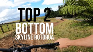
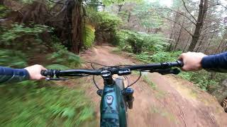
The catalyst for the Skyline Gravity Park that has now become somewhat of an institution. This Intermediate/Advanced trail provides a plethora of mountain bike experience with machine built berms, step downs, gap jumps, hand built trail, the list goes on. Oh, and not to mention it now leads into Moss Piglet and our new jumps track”. All of this fun wrapped up in a warp speed package of 3-4 minutes top to bottom.

Bike Park

Recent Activity on Trail

Past Week
  • 2 rides
  • 16 miles average
6 Months
  • 42 rides
  • 16 miles avg distance
All
  • 286 rides
  • Last: Jun 13, 2026
c1c2c3c4
January
February
March
April
May
June
July
August
September
October
November
December
update trails status or condition

Upper Sprint Warrior Trail Reports

statusdatedescription
Sep 1, 2024 @ 1:37pm
Sep 1, 2024
Jul 28, 2024 @ 3:51pm
Jul 28, 2024
Jul 20, 2023 @ 6:02am
Jul 20, 2023
Fun and fast. Small wet sections in some berms.
Mar 3, 2023 @ 5:51am
Mar 3, 2023
Aug 8, 2021 @ 10:57pm
Aug 8, 2021
Some trail maintenance going on at the start but apart from that 10m stretch it’s really good. Fast and flowy.
more »
Status:
on Sep 1, 2024
Ideal
Avg: 4.36 (16 votes)
Your vote: 0

view (8,702)
close
3D
Trail Conditions
  • Unknown
  • Snow Groomed
  • Snow Packed
  • Snow Covered
  • Snow Cover Partial
  • Freeze/thaw Cycle
  • Icy
  • Prevalent Mud
  • Wet
  • Variable
  • Ideal
  • Dry
  • Very Dry
Trail Flow (Ridden Direction)
Trailforks scans users ridelogs to determine the most popular direction each trail is ridden. A good flowing trail network will have most trails flowing in a single direction according to their intension.
The colour categories are based on what percentage of riders are riding a trail in its intended direction.
  • > 96%
  • > 90%
  • > 80%
  • > 70%
  • > 50%
  • < 50%
  • bi-directional trail
  • no data
Trail Last Ridden
Trailforks scans ridelogs to determine the last time a trail was ridden.
  • < 2 days
  • < 1 week
  • < 2 weeks
  • < 1 month
  • < 6 months
  • > 6 months
Trail Ridden Direction
The intended direction a trail should be ridden.
  • Downhill Only
  • Downhill Primary
  • Both Directions
  • Uphill Primary
  • Uphill Only
  • One Direction
Contribute Details
Colors indicate trail is missing specified detail.
  • Description
  • Photos
  • Description & Photos
  • Videos
Trail Popularity ?
Trailforks scans ridelogs to determine which trails are ridden the most in the last 9 months. Trails are compared with nearby trails in the same city region with a possible 25 colour shades. Think of this as a heatmap, more rides = more kinetic energy = warmer colors.
  • most popular
  • popular
  • less popular
  • not popular
ATV/ORV/OHV Filter
Max Vehicle Width
inches
US Cell Coverage
Legend
cell carrier legend

Radar Time
Activity Recordings
Trailforks uses anonymized public activity data. ?
Activity Recordings
Trailforks uses anonymized public activity data. ?
Personal Heatmap
Activity Types
all / none
Options
2
Date range month
Winter Trails
Warning A routing network for winter maps does not exist. Selecting trails using the winter trails layer has been disabled.
Missing Trails
Most Popular
Least Popular
Trails are colored based on popularity. The more popular a trail is, the more red. Less popular trails trend towards green.
Jump Magnitude Heatmap
Heatmap of where riders jump on trails. Zoom in to see individual jumps, click circles to view jump details.
BC Backroad Status

Service Road Atlas is a free to use, community-driven service for viewing and creating reports on the numerous back-country service roads around B.C. and Alberta.

map legend
Slope Aspect
Direction the slope faces
Flat N NE E SE S SW W NW
Trails Deemphasized
Trails are shown in grey.
disable
Only show trails with no bike usage.
Enable
Suggested Layers
Based on selected activity type

    Save the current map location and zoom level as your default home location whenever this page is loaded.

    Save
        Directions to upper-sprint-warrior trailhead (-38.112220, 176.212270)

        Photos

        6 more »
        38 |
        Jan 31, 2026 @ 12:13am
        Jan 31, 2026
        177 |
        Jul 7, 2016 @ 1:24am
        Jul 7, 2016
        305 |
        Feb 21, 2014 @ 3:17am
        Feb 21, 2014
        403 |
        Aug 11, 2014 @ 1:52pm
        Aug 11, 2014

        Videos

        25 more »
        youtuber Top To Bottom Skyline Rotorua Bike Park NZ
        2:53 | 602 | Apr 1, 2021 , Rotorua
        youtuber Top 2 Bottom BERMS at 440 Mountain Bike Park
        7:18 | 330 | Mar 25, 2021 , Rotorua
        youtuber Upper Sprint Warrior | Skyline, Rotorua
        2:09 | 293 | Oct 29, 2023 , Rotorua
        Sprint Warrior, Huck’s N Hooves, Ten Fifty...
        3:51 | 175 | Feb 28, 2023 , Rotorua

        Routes with this trail

        3,609 ft 4 Point to Point Race
        The 2017 Kidsworx Warrior DownHill course for kids 9-12 years of age as part of Crankworx Rotorua
        2,779 ft 3 ft 6 Point to Point Race
        The 2017 Kidsworx downhill course for kids aged 6-9 years of age as part of Crankworx Rotorua
        4,072 ft 3 ft 6 Shuttled Race
        The official course for Kidsworx Rotorua DH event

        1 Review & Comments


        We hope you've been enjoying Trailforks!

        Create a FREE account to view trail comments and much more.

        Frequently Asked Questions About Upper Sprint Warrior

        Where is Upper Sprint Warrior located?
        Upper Sprint Warrior is located in Skyline - Rotorua, Rotorua, New Zealand. It is part of the Skyline - Rotorua trail network. The trailhead is located at coordinates -38.11222, 176.21227.
        How hard is Upper Sprint Warrior?
        Upper Sprint Warrior is rated as Blue difficulty. The average grade is 11.6%.
        What is the elevation gain for Upper Sprint Warrior?
        The trail has 52 m of elevation descent. The elevation ranges from 412 m to 465 m.
        Is Upper Sprint Warrior a point to point trail?
        Yes, Upper Sprint Warrior is a point to point trail. The direction is Downhill Only. The trail type is singletrack.

        Hit the Trail

        Open in App

        Get this trail on your phone instantly.
        open trail in app

        Download Trail

        Save to wishlist, Garmin & download.
        save the trail

        Find Related Routes

        Find routes and users activities that include this trail.
        find routes for this trail

        You must enter a description before submitting.