more stats
1,266 ft
Distance
-344 ft
Descent
00:08:10
Avg time
-344 ft
Altitude change
1,759 ft
Altitude min
2,103 ft
Altitude max
2,103 ft
Altitude start
1,759 ft
Altitude end
-27.2%
Grade
-45.9%
Grade max
-9.5%
Grade min
1,266 ft
Distance down
00:08:10
Avg time

Upper Vic's Details

  • Activities
    • Mountain Bike
    • Hike
  • Riding Area
    Burke Mountain
    Coquitlam, British Columbia
  • Difficulty Rating
  • Voted Difficulty
    Double Black Diamond (4 votes)
  • Local Popularity
    60 in Mountain Biking [+]
    • 60 in Hiking
  • Global Ranking
    #78168 in Mountain Biking [+]
    • #90223 in Hiking
  • Hiking SAC Scale
    T1 Hiking
  • Trail Type
    Singletrack
  • Bike Type
    DH, AM
  • Direction
    Downhill Only
    Popular Direction Shown
  • Climb Difficulty
    Green
  • Physical Rating
    Moderate
  • Trail Visibility
    Always easy to follow
  • Dogs Allowed
    Yes
  • TTFs on Trail
    Rock Garden

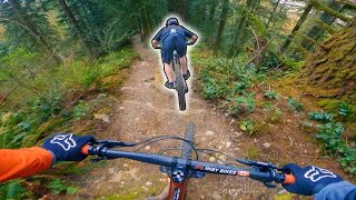
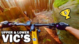
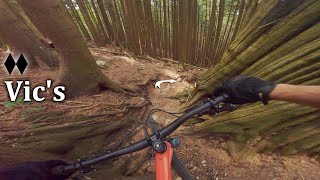
Often cited as the toughest trail on the mountain to clean, Upper Vic's is extremely steep, natural and very technical. Many tight corners into rooty/rocky chutes will challenge your slow speed abilities. Things become exceptionally tricky when there is moisture on the roots or gravel in the chutes. Expect little to nothing in the way of ride-arounds. Good luck

This trail is unsanctioned.

Trail Supporters
Traditionally Indigenous Territory

Recent Activity on Trail

Past Week
  • 1 rides
  • 10 miles average
6 Months
  • 16 rides
  • 13 miles avg distance
All
  • 179 rides
  • Last: Jun 11, 2026
c1c2c3c4
January
February
March
April
May
June
July
August
September
October
November
December
update trails status or condition

Upper Vic's Trail Reports

statusdatedescription
Jan 29, 2026 @ 10:10pm (America/Vancouver)
Jan 29, 2026
reporter Trees cleared.
Jan 27, 2026 @ 2:47pm (America/Vancouver)
Jan 27, 2026
2 trees down near the end
Nov 23, 2025 @ 7:25pm (America/Vancouver)
Nov 23, 2025
reporter Tree cleared with hand saw.
Jan 10, 2025 @ 1:20pm
Jan 10, 2025
reporter Tree cleared.
Jan 9, 2025 @ 5:58pm
Jan 9, 2025
reporter Big tree down at entrance. Chainsaw definitely required, 29" bike wheel for scale.
more »
Status:
on Jan 29, 2026
Avg: 4.33 (13 votes)
Your vote: 0

view (1,001)
close
3D
Trail Conditions
  • Unknown
  • Snow Groomed
  • Snow Packed
  • Snow Covered
  • Snow Cover Partial
  • Freeze/thaw Cycle
  • Icy
  • Prevalent Mud
  • Wet
  • Variable
  • Ideal
  • Dry
  • Very Dry
Trail Flow (Ridden Direction)
Trailforks scans users ridelogs to determine the most popular direction each trail is ridden. A good flowing trail network will have most trails flowing in a single direction according to their intension.
The colour categories are based on what percentage of riders are riding a trail in its intended direction.
  • > 96%
  • > 90%
  • > 80%
  • > 70%
  • > 50%
  • < 50%
  • bi-directional trail
  • no data
Trail Last Ridden
Trailforks scans ridelogs to determine the last time a trail was ridden.
  • < 2 days
  • < 1 week
  • < 2 weeks
  • < 1 month
  • < 6 months
  • > 6 months
Trail Ridden Direction
The intended direction a trail should be ridden.
  • Downhill Only
  • Downhill Primary
  • Both Directions
  • Uphill Primary
  • Uphill Only
  • One Direction
Contribute Details
Colors indicate trail is missing specified detail.
  • Description
  • Photos
  • Description & Photos
  • Videos
Trail Popularity ?
Trailforks scans ridelogs to determine which trails are ridden the most in the last 9 months. Trails are compared with nearby trails in the same city region with a possible 25 colour shades. Think of this as a heatmap, more rides = more kinetic energy = warmer colors.
  • most popular
  • popular
  • less popular
  • not popular
ATV/ORV/OHV Filter
Max Vehicle Width
inches
US Cell Coverage
Legend
cell carrier legend

Radar Time
Activity Recordings
Trailforks uses anonymized public activity data. ?
Activity Recordings
Trailforks uses anonymized public activity data. ?
Personal Heatmap
Activity Types
all / none
Options
2
Date range month
Winter Trails
Warning A routing network for winter maps does not exist. Selecting trails using the winter trails layer has been disabled.
Missing Trails
Most Popular
Least Popular
Trails are colored based on popularity. The more popular a trail is, the more red. Less popular trails trend towards green.
Jump Magnitude Heatmap
Heatmap of where riders jump on trails. Zoom in to see individual jumps, click circles to view jump details.
BC Backroad Status

Service Road Atlas is a free to use, community-driven service for viewing and creating reports on the numerous back-country service roads around B.C. and Alberta.

map legend
Slope Aspect
Direction the slope faces
Flat N NE E SE S SW W NW
Trails Deemphasized
Trails are shown in grey.
disable
Only show trails with no bike usage.
Enable
Suggested Layers
Based on selected activity type

    Save the current map location and zoom level as your default home location whenever this page is loaded.

    Save
        Directions to upper-vic-s trailhead (49.327920, -122.737890)

        Photos

        10 more »
        154 |
        May 31, 2018 @ 10:07pm
        May 31, 2018
        116 |
        May 31, 2018 @ 10:06pm
        May 31, 2018
        42 |
        Jan 29, 2026 @ 10:10pm
        Jan 29, 2026
        42 |
        Jan 29, 2026 @ 10:10pm
        Jan 29, 2026

        Videos

        12 more »
        youtuber Growing Up Here is a  Advantage
        12:49 | 493 | Jun 26, 2022 , Coquitlam
        youtuber Upper and Lower Vic's | Burke Mountain,...
        5:04 | 1298 | Oct 25, 2020 , Coquitlam
        youtuber BEST TRAILS ON BURKE MTN! // UPPER & LOWER...
        4:13 | 566 | Jun 15, 2020 , Coquitlam
        The Fastest Way Down is Vertical | Vic's -...
        6:38 | 184 | Aug 14, 2023 , Coquitlam

        Trail Products

        4 Reviews & Comments


        We hope you've been enjoying Trailforks!

        Create a FREE account to view trail comments and much more.

        • #8503 - 4,555 views

        Frequently Asked Questions About Upper Vic's

        Where is Upper Vic's located?
        Upper Vic's is located in Burke Mountain, Coquitlam, British Columbia, Canada. It is part of the Burke Mountain trail network. The trailhead is located at coordinates 49.32792, -122.73789.
        How hard is Upper Vic's?
        Upper Vic's is rated as Double Black Diamond difficulty. The physical rating is Moderate. The average grade is 27.2%. The climb difficulty is rated Green.
        What is the elevation gain for Upper Vic's?
        The trail has 105 m of elevation descent. The elevation ranges from 536 m to 641 m.
        Is Upper Vic's a point to point trail?
        Yes, Upper Vic's is a point to point trail. The direction is Downhill Only. The trail type is singletrack.

        Hit the Trail

        Open in App

        Get this trail on your phone instantly.
        open trail in app

        Download Trail

        Save to wishlist, Garmin & download.
        save the trail

        Find Related Routes

        Find routes and users activities that include this trail.
        find routes for this trail

        You must enter a description before submitting.