more stats
4,514 ft
Distance
3 ft
Climb
-121 ft
Descent
00:10:25
Avg time
-120 ft
Altitude change
7,290 ft
Altitude min
7,413 ft
Altitude max
7,413 ft
Altitude start
7,293 ft
Altitude end
-2.7%
Grade
-18.5%
Grade max
2.5%
Grade min
607 ft
Distance climb
2,703 ft
Distance down
1,155 ft
Distance flat
00:10:25
Avg time

UPS Lower Details

  • Activities
    • Mountain Bike
    • Hike
    • Trail Running
  • Riding Area
    La Sal Mountains
    Moab, Utah
  • Difficulty Rating
  • Voted Difficulty
    Black Diamond (4 votes)
  • Local Popularity
    100 in Mountain Biking [+]
    • 80 in Trail Running
    • 75 in Hiking
  • Global Ranking
    #3165 in Mountain Biking [+]
    • #53705 in Trail Running
    • #24694 in Hiking
  • Trail Type
    Singletrack
  • Bike Type
    AM, XC
  • Direction
    Downhill Primary
    Popular Direction Shown
  • Dogs Allowed
    Yes
  • eBike Allowed
  • Land Owner
    USFS

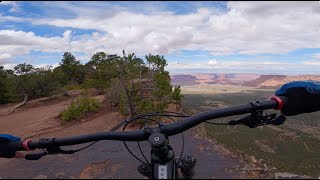
This trail is the cherry on top when riding Porcupine rim Amazing views of Castle valley are afforded after 50 meters of riding. The trail has good flow with some spicy sections. There is some pedalling but no uphill sections. The exposed rock section near the bottom is a highlight of the trail giving the exposed granite slabs of Squamish a run for their money. Don't miss this trail!

Trail Supporters
  • BLM
    BLM
    Land Manager

  • USFS
    Land Manager
Local Trail Association
Traditionally Indigenous Territory

Recent Activity on Trail

Past Week
  • 10 rides
  • 22 miles average
6 Months
  • 242 rides
  • 22 miles avg distance
All
  • 2,602 rides
  • Last: Jun 24, 2026
c1c2c3c4
January
February
March
April
May
June
July
August
September
October
November
December
Status:
on Jun 22, 2026
Dry
Avg: 4.77 (71 votes)
Your vote: 0

view (14,947)
close
3D
Trail Conditions
  • Unknown
  • Snow Groomed
  • Snow Packed
  • Snow Covered
  • Snow Cover Partial
  • Freeze/thaw Cycle
  • Icy
  • Prevalent Mud
  • Wet
  • Variable
  • Ideal
  • Dry
  • Very Dry
Trail Flow (Ridden Direction)
Trailforks scans users ridelogs to determine the most popular direction each trail is ridden. A good flowing trail network will have most trails flowing in a single direction according to their intension.
The colour categories are based on what percentage of riders are riding a trail in its intended direction.
  • > 96%
  • > 90%
  • > 80%
  • > 70%
  • > 50%
  • < 50%
  • bi-directional trail
  • no data
Trail Last Ridden
Trailforks scans ridelogs to determine the last time a trail was ridden.
  • < 2 days
  • < 1 week
  • < 2 weeks
  • < 1 month
  • < 6 months
  • > 6 months
Trail Ridden Direction
The intended direction a trail should be ridden.
  • Downhill Only
  • Downhill Primary
  • Both Directions
  • Uphill Primary
  • Uphill Only
  • One Direction
Contribute Details
Colors indicate trail is missing specified detail.
  • Description
  • Photos
  • Description & Photos
  • Videos
Trail Popularity ?
Trailforks scans ridelogs to determine which trails are ridden the most in the last 9 months. Trails are compared with nearby trails in the same city region with a possible 25 colour shades. Think of this as a heatmap, more rides = more kinetic energy = warmer colors.
  • most popular
  • popular
  • less popular
  • not popular
ATV/ORV/OHV Filter
Max Vehicle Width
inches
US Cell Coverage
Legend
cell carrier legend

Radar Time
Activity Recordings
Trailforks uses anonymized public activity data. ?
Activity Recordings
Trailforks uses anonymized public activity data. ?
Personal Heatmap
Activity Types
all / none
Options
2
Date range month
Winter Trails
Warning A routing network for winter maps does not exist. Selecting trails using the winter trails layer has been disabled.
Missing Trails
Most Popular
Least Popular
Trails are colored based on popularity. The more popular a trail is, the more red. Less popular trails trend towards green.
Jump Magnitude Heatmap
Heatmap of where riders jump on trails. Zoom in to see individual jumps, click circles to view jump details.
BC Backroad Status

Service Road Atlas is a free to use, community-driven service for viewing and creating reports on the numerous back-country service roads around B.C. and Alberta.

map legend
Slope Aspect
Direction the slope faces
Flat N NE E SE S SW W NW
Trails Deemphasized
Trails are shown in grey.
disable
Only show trails with no bike usage.
Enable
Suggested Layers
Based on selected activity type

    Save the current map location and zoom level as your default home location whenever this page is loaded.

    Save
        Directions to ups-lower trailhead (38.574980, -109.346700)

        Photos

        23 more »
        994 |
        Dec 2, 2017 @ 11:23pm
        Dec 2, 2017
        782 |
        Jan 21, 2017 @ 11:03pm
        Jan 21, 2017
        34 |
        Dec 22, 2025 @ 1:31pm
        Dec 22, 2025
        28 |
        May 10, 2025 @ 4:05pm
        May 10, 2025

        Videos

        13 more »
        Moab Enchilada Helpings
        21:02 | 11 | May 15, 2026 , Moab
        Whole Enchilada - Moab (Utah)
        51:19 | 19 | Apr 16, 2026 , Moab
        An Epic Ride: Mountain Biking The Whole...
        25:46 | 62 | Oct 10, 2025 , Moab
        On ride un classic en shuttle à Moab !!!
        14:57 | 71 | Jun 4, 2025 , Moab

        Trail Lists

        Routes with this trail

        3.9 27 miles 1,269 ft 8 Shuttled
        The Whole Enchilada! A truly iconic Moab ride. From tight alpine switchbacks to steep sandstone rollers...
        3.6 20 miles 460 ft 7 Shuttled
        - Starting from Country. This is possibly one of the best mountain bike rides in the world. We have...
        5.0 27 miles 1,486 ft 13 Shuttled
        This is the whole enchilada /w , but instead of LPS, you take the raptor route! Slightly more intermediate...

        5 Reviews & Comments


        We hope you've been enjoying Trailforks!

        Create a FREE account to view trail comments and much more.

        • By toddTF Pro Trailforks & contributors
        • #8854 - 12,437 views

        Frequently Asked Questions About UPS Lower

        Where is UPS Lower located?
        UPS Lower is located in La Sal Mountains, Moab, Utah, United States. It is part of the La Sal Mountains trail network. The trailhead is located at coordinates 38.57498, -109.3467.
        How hard is UPS Lower?
        UPS Lower is rated as Black Diamond difficulty. The average grade is 2.7%.
        What is the elevation gain for UPS Lower?
        UPS Lower has 3 ft of elevation gain. The trail has 121 ft of elevation descent. The elevation ranges from 7,290 ft to 7,413 ft.
        Is UPS Lower a point to point trail?
        UPS Lower is not a point to point trail. The direction is Downhill Primary. The trail type is singletrack.

        Hit the Trail

        Open in App

        Get this trail on your phone instantly.
        open trail in app

        Download Trail

        Save to wishlist, Garmin & download.
        save the trail

        Find Related Routes

        Find routes and users activities that include this trail.
        find routes for this trail

        You must enter a description before submitting.