more stats
2.6 miles
Distance
29 ft
Climb
-1,187 ft
Descent
00:10:50
Avg time
-1,158 ft
Altitude change
8,632 ft
Altitude min
9,790 ft
Altitude max
9,790 ft
Altitude start
8,632 ft
Altitude end
-8.4%
Grade
-29%
Grade max
11.5%
Grade min
817 ft
Distance climb
2 miles
Distance down
1,585 ft
Distance flat
00:10:50
Avg time

Valhalla Details

  • Activities
    • Mountain Bike
  • Riding Area
    Snowmass Bike Park
    Snowmass Village, Colorado
  • Difficulty Rating
  • Voted Difficulty
    Black Diamond (2 votes)
  • Local Popularity
    90 in Mountain Biking
  • Global Ranking
    #37850 in Mountain Biking
  • Trail Type
    Machine Groomed
  • Bike Type
    DH
  • Trail Visibility
    Always easy to follow
  • eBike Allowed
  • TTFs on Trail
    Berm, Bridge, Drop, Jump, Gap Jump, Wallride
  • Year Opened
    2012
  • Land Owner

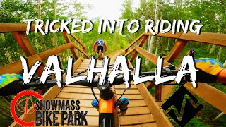
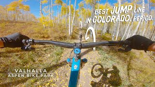
Debuting in 2012, Valhalla is a 2.75-mile monster of a trail designed and built by Gravity Logic. It invites the toughest riders – and those who strive to be – to tackle an assortment of freeride challenges over the course of its 1,400-foot vertical drop. Valhalla sets a winding course through the aspen trees and features berms, jumps, bridges, table tops, a wall ride, drop zone, fruit bowl and rainbows, eventually delivering thrilled riders to Snowmass Base Village. Its one thing to describe it, quite another thing to experience it. Check out the video above.

New for 2017 is a short jump section that are more like sender with dip you need to clear. You can roll it if you go slow, you can clear it if you go fast, but if you don't make the dip you can hit the edge pretty hard. There are warning signs on he trail of the new section, look before you leap.

Access Info

Elk Camp Gondola

Trail Supporters

  • USFS
    Land Manager

Bike Park

Traditionally Indigenous Territory

Recent Activity on Trail

Past Week
  • 0 rides
  •  
6 Months
  • 0 rides
  •  
All
  • 200 rides
  • Last: Jun 4, 2026
c1c2c3c4
January
February
March
April
May
June
July
August
September
October
November
December
Status:
on Sep 28, 2025
Ideal
Avg: 4.55 (12 votes)
Your vote: 0

view (2,384)
close
3D
Trail Conditions
  • Unknown
  • Snow Groomed
  • Snow Packed
  • Snow Covered
  • Snow Cover Partial
  • Freeze/thaw Cycle
  • Icy
  • Prevalent Mud
  • Wet
  • Variable
  • Ideal
  • Dry
  • Very Dry
Trail Flow (Ridden Direction)
Trailforks scans users ridelogs to determine the most popular direction each trail is ridden. A good flowing trail network will have most trails flowing in a single direction according to their intension.
The colour categories are based on what percentage of riders are riding a trail in its intended direction.
  • > 96%
  • > 90%
  • > 80%
  • > 70%
  • > 50%
  • < 50%
  • bi-directional trail
  • no data
Trail Last Ridden
Trailforks scans ridelogs to determine the last time a trail was ridden.
  • < 2 days
  • < 1 week
  • < 2 weeks
  • < 1 month
  • < 6 months
  • > 6 months
Trail Ridden Direction
The intended direction a trail should be ridden.
  • Downhill Only
  • Downhill Primary
  • Both Directions
  • Uphill Primary
  • Uphill Only
  • One Direction
Contribute Details
Colors indicate trail is missing specified detail.
  • Description
  • Photos
  • Description & Photos
  • Videos
Trail Popularity ?
Trailforks scans ridelogs to determine which trails are ridden the most in the last 9 months. Trails are compared with nearby trails in the same city region with a possible 25 colour shades. Think of this as a heatmap, more rides = more kinetic energy = warmer colors.
  • most popular
  • popular
  • less popular
  • not popular
ATV/ORV/OHV Filter
Max Vehicle Width
inches
US Cell Coverage
Legend
cell carrier legend

Radar Time
Activity Recordings
Trailforks uses anonymized public activity data. ?
Activity Recordings
Trailforks uses anonymized public activity data. ?
Personal Heatmap
Activity Types
all / none
Options
2
Date range month
Winter Trails
Warning A routing network for winter maps does not exist. Selecting trails using the winter trails layer has been disabled.
Missing Trails
Most Popular
Least Popular
Trails are colored based on popularity. The more popular a trail is, the more red. Less popular trails trend towards green.
Jump Magnitude Heatmap
Heatmap of where riders jump on trails. Zoom in to see individual jumps, click circles to view jump details.
BC Backroad Status

Service Road Atlas is a free to use, community-driven service for viewing and creating reports on the numerous back-country service roads around B.C. and Alberta.

map legend
Slope Aspect
Direction the slope faces
Flat N NE E SE S SW W NW
Trails Deemphasized
Trails are shown in grey.
disable
Only show trails with no bike usage.
Enable
Suggested Layers
Based on selected activity type

    Save the current map location and zoom level as your default home location whenever this page is loaded.

    Save
        Directions to valhalla trailhead (39.189400, -106.936390)

        Photos

        59 more »
        133 |
        Jul 1, 2021 @ 2:39pm
        Jul 1, 2021
        222 |
        Jul 1, 2021 @ 2:39pm
        Jul 1, 2021
        104 |
        Jul 1, 2021 @ 2:39pm
        Jul 1, 2021
        364 |
        Jul 1, 2021 @ 2:40pm
        Jul 1, 2021

        Videos

        14 more »
        youtuber ♦Valhalla♦ By Mistake... Aspen Snowmass...
        11:30 | 692 | Jul 20, 2020 , Snowmass Village
        Is Valhalla Better Than Rainmaker? - Valhalla...
        5:12 | 406 | Dec 1, 2020 , Snowmass Village
        youtuber Air Under The Tires... Mountain Biking...
        11:23 | 784 | Oct 16, 2018 , Snowmass Village
        Nailed it
        0:14 | 159 | Jul 5, 2024 , Snowmass Village

        Routes with this trail

        10 miles 1,876 ft 13 Loop
        I created this loop as a semi-epic after hours or Fall weekday ride to enable great XC training climb and...
        3.4 12 miles 802 ft 8 Shuttled

        3 Reviews & Comments


        We hope you've been enjoying Trailforks!

        Create a FREE account to view trail comments and much more.

        Frequently Asked Questions About Valhalla

        Where is Valhalla located?
        Valhalla is located in Bike Snowmass, Snowmass Village, Colorado, United States. It is part of the Bike Snowmass trail network. The trailhead is located at coordinates 39.1894, -106.93639.
        How hard is Valhalla?
        Valhalla is rated as Black Diamond difficulty. The average grade is 8.4%.
        What is the elevation gain for Valhalla?
        Valhalla has 9 m of elevation gain. The trail has 362 m of elevation descent. The elevation ranges from 2,631 m to 2,984 m.
        How long is Valhalla?
        Valhalla is 4.2 km long. The trail type is machine groomed.

        Hit the Trail

        Open in App

        Get this trail on your phone instantly.
        open trail in app

        Download Trail

        Save to wishlist, Garmin & download.
        save the trail

        Find Related Routes

        Find routes and users activities that include this trail.
        find routes for this trail

        You must enter a description before submitting.