more stats
3.3 miles
Distance
6 ft
Climb
-1,326 ft
Descent
00:25:52
Avg time
-1,320 ft
Altitude change
6,452 ft
Altitude min
7,772 ft
Altitude max
7,772 ft
Altitude start
6,453 ft
Altitude end
-7.6%
Grade
-36.1%
Grade max
3.4%
Grade min
272 ft
Distance climb
3 miles
Distance down
66 ft
Distance flat
00:25:52
Avg time

Van Sickle Trail Details

  • Activities
    • Mountain Bike
    • Horse
    • Hike
    • Trail Running
  • Riding Area
    Van Sickle
    Stateline, Nevada
  • Difficulty Rating
  • Voted Difficulty
    Black Diamond (2 votes)
  • Global Ranking
    #102988 in Mountain Biking [+]
    • #127087 in Trail Running
    • #119559 in Hiking
  • Hiking SAC Scale
    T2 Mountain Hiking
  • Trail Type
    Singletrack
  • Bike Type
    AM, XC
  • Direction
    Both Directions
    Popular Direction Shown
  • Climb Difficulty
    Black Diamond
  • Physical Rating
    Hard
  • Trail Visibility
    Always easy to follow
  • Season
    Summer, Fall
  • Dogs Allowed
    Yes
  • eBike Allowed
  • TTFs on Trail
    Rock Garden

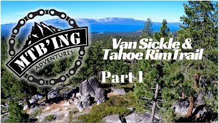
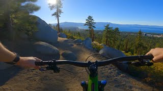
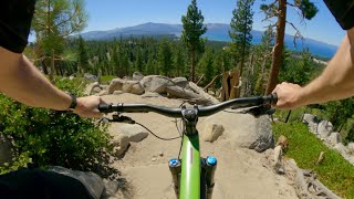
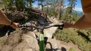
This trail connects the casino core of South Lake Tahoe/Stateline to the Rim Trail and is one of the latest additions to the South Shore trail system. Beginning at the top of the Van Sickle Bi-State Park, the trail goes through a Sugar Pine forest, then through an area denuded by the 2002 Gondola Fire, past a delightful waterfall/cascade, then through willows and mature pine forests to the TRT at an elevation of 7,777 ft. The trail is built to be ridden both up and down incorporating rest areas and overlooks along the way. It’s a great ride providing some of the best lake views.

An important note about this trail is its sensitivity to bike traffic. As the only trail near the epicenter of South Lake hotel accommodations, many tourists challenge themselves to hike the trail. As they enjoy the views, wildlife, and altitude, they are often not aware of incoming mountain bikes. Compound that with the difficulty in finding a safe place to get off the trail results in challenges passing hikers. These issues are most prevalent on the lower half of the trail. Be overtly courteous when passing hikers.

Access Info

The lower trailhead departs from the end of the paved road in Van Sickle Bi-State Park. The Van Sickle Trail can also be accessed from a spur that departs north from the very top of Saddle Rd (Adams Way).

The upper trailhead is on the TRT and is 3.5 miles south of the TRT/SR-207 (Kingsbury Grade) intersection or by accessing the TRT 1 mile south near the Stagecoach ski lift in Heavenly Village.

Disclaimer

Be sensitive to numerous hikers that frequent this trail.

Trail Supporters
Local Trail Association
Traditionally Indigenous Territory

Recent Activity on Trail

Past Week
  • 6 rides
  • 13 miles average
6 Months
  • 23 rides
  • 10 miles avg distance
All
  • 380 rides
  • Last: Jun 18, 2026
c1c2c3c4
January
February
March
April
May
June
July
August
September
October
November
December
update trails status or condition

Van Sickle Trail Trail Reports

statusdatedescription
Apr 1, 2026 @ 5:34pm (America/Los_Angeles)
Apr 1, 2026
Pedaled up to 7400', hero dirt and no snow at all. Supposed to get snow tonight but if it's not a lot VS should be firing again in a few days.
Sep 9, 2025 @ 3:07pm
Sep 9, 2025
Fun flowy and slight chunk downhill
Sep 7, 2025 @ 3:08pm
Sep 7, 2025
Jun 14, 2025 @ 3:15pm
Jun 14, 2025
All clear. Good to go.
Mar 26, 2025 @ 5:14pm
Mar 26, 2025
Snow starts showing up about a half mile from the bottom, not quite ready yet
more »
Status:
on Apr 1, 2026
Ideal
Avg: 4.29 (28 votes)
Your vote: 0

view (41)
close
3D
Trail Conditions
  • Unknown
  • Snow Groomed
  • Snow Packed
  • Snow Covered
  • Snow Cover Partial
  • Freeze/thaw Cycle
  • Icy
  • Prevalent Mud
  • Wet
  • Variable
  • Ideal
  • Dry
  • Very Dry
Trail Flow (Ridden Direction)
Trailforks scans users ridelogs to determine the most popular direction each trail is ridden. A good flowing trail network will have most trails flowing in a single direction according to their intension.
The colour categories are based on what percentage of riders are riding a trail in its intended direction.
  • > 96%
  • > 90%
  • > 80%
  • > 70%
  • > 50%
  • < 50%
  • bi-directional trail
  • no data
Trail Last Ridden
Trailforks scans ridelogs to determine the last time a trail was ridden.
  • < 2 days
  • < 1 week
  • < 2 weeks
  • < 1 month
  • < 6 months
  • > 6 months
Trail Ridden Direction
The intended direction a trail should be ridden.
  • Downhill Only
  • Downhill Primary
  • Both Directions
  • Uphill Primary
  • Uphill Only
  • One Direction
Contribute Details
Colors indicate trail is missing specified detail.
  • Description
  • Photos
  • Description & Photos
  • Videos
Trail Popularity ?
Trailforks scans ridelogs to determine which trails are ridden the most in the last 9 months. Trails are compared with nearby trails in the same city region with a possible 25 colour shades. Think of this as a heatmap, more rides = more kinetic energy = warmer colors.
  • most popular
  • popular
  • less popular
  • not popular
ATV/ORV/OHV Filter
Max Vehicle Width
inches
US Cell Coverage
Legend
cell carrier legend

Radar Time
Activity Recordings
Trailforks uses anonymized public activity data. ?
Activity Recordings
Trailforks uses anonymized public activity data. ?
Personal Heatmap
Activity Types
all / none
Options
2
Date range month
Winter Trails
Warning A routing network for winter maps does not exist. Selecting trails using the winter trails layer has been disabled.
Missing Trails
Most Popular
Least Popular
Trails are colored based on popularity. The more popular a trail is, the more red. Less popular trails trend towards green.
Jump Magnitude Heatmap
Heatmap of where riders jump on trails. Zoom in to see individual jumps, click circles to view jump details.
BC Backroad Status

Service Road Atlas is a free to use, community-driven service for viewing and creating reports on the numerous back-country service roads around B.C. and Alberta.

map legend
Slope Aspect
Direction the slope faces
Flat N NE E SE S SW W NW
Trails Deemphasized
Trails are shown in grey.
disable
Only show trails with no bike usage.
Enable
Suggested Layers
Based on selected activity type

    Save the current map location and zoom level as your default home location whenever this page is loaded.

    Save
        Directions to van-sickle-trail trailhead (38.958790, -119.895340)

        Photos

        41 more »
        127 |
        Jun 8, 2024 @ 3:28pm
        Jun 8, 2024
        145 |
        Jun 24, 2023 @ 2:34pm
        Jun 24, 2023
        170 |
        Jun 24, 2023 @ 12:03pm
        Jun 24, 2023
        157 |
        Jun 24, 2023 @ 12:03pm
        Jun 24, 2023

        Videos

        10 more »
        youtuber Van Sickle & Tahoe Rim Trail Part 1 (South...
        1304 | Oct 2, 2017 , Stateline
        youtuber Van Sickle / Lake Tahoe / MTB
        12:52 | 48 | Oct 11, 2021 , Stateline
        youtuber Van Sickle / Lake Tahoe / MTB
        14:45 | 66 | Aug 23, 2022 , Stateline
        youtuber Van Sickle (2023) / South Lake Tahoe / MTB
        10:41 | 97 | Jun 23, 2023 , Stateline

        Routes with this trail

        5.0 20 miles 3,040 ft 10 Shuttled
        Start your ride at the Tahoe Rim Trail trailhead at Spooner Summit. Shuttles are available from several...
        43 miles 7,335 ft 12
        to TRT and Monument Pass, descent to Cold Creek, up Insence Cedar, up to Armstrong Pass, to Toads, to...
        9 miles 1,715 ft 6
        sfgsdfgdfgdfgfdgdfgsdfgdasgadgadgadgadsgadsgasdgasgasdgas

        9 Reviews & Comments


        We hope you've been enjoying Trailforks!

        Create a FREE account to view trail comments and much more.

        • By FRguild & contributors
        • #7485 - 15,562 views

        Frequently Asked Questions About Van Sickle Trail

        Where is Van Sickle Trail located?
        Van Sickle Trail is located in Van Sickle, Stateline, Nevada, United States. It is part of the Van Sickle trail network. The trailhead is located at coordinates 38.95879, -119.89534.
        How hard is Van Sickle Trail?
        Van Sickle Trail is rated as Black Diamond difficulty. The physical rating is Hard. The average grade is 7.6%. The climb difficulty is rated Black Diamond.
        What is the elevation gain for Van Sickle Trail?
        Van Sickle Trail has 6 ft of elevation gain. The trail has 1,326 ft of elevation descent. The elevation ranges from 6,452 ft to 7,772 ft.
        Is Van Sickle Trail a point to point trail?
        Van Sickle Trail is not a point to point trail. The direction is Both Directions. The trail type is singletrack.

        Hit the Trail

        Open in App

        Get this trail on your phone instantly.
        open trail in app

        Download Trail

        Save to wishlist, Garmin & download.
        save the trail

        Find Related Routes

        Find routes and users activities that include this trail.
        find routes for this trail

        You must enter a description before submitting.