more stats
3,396 ft
Distance
26 ft
Climb
-723 ft
Descent
00:18:25
Avg time
-697 ft
Altitude change
9,760 ft
Altitude min
10,481 ft
Altitude max
10,457 ft
Altitude start
9,760 ft
Altitude end
-20.5%
Grade
-65.7%
Grade max
21.9%
Grade min
394 ft
Distance climb
2,966 ft
Distance down
39 ft
Distance flat
00:18:25
Avg time

Velociraptor Upper Details

  • Activities
    • Mountain Bike
  • Riding Area
    Mammoth Mountain Bike Park
    Mammoth Lakes, California
  • Difficulty Rating
  • Local Popularity
    20 in Mountain Biking
  • Global Ranking
    #123483 in Mountain Biking
  • Trail Type
    Singletrack
  • Bike Type
    DH, AM
  • Direction
    Downhill Only
    Popular Direction Shown
  • TTFs on Trail
    Rock Face, Rock Garden
  • Year Opened
    2018

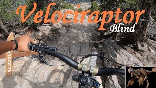
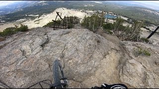
Some steep tech, rock faces, loose pumice, and a mandatory drop.
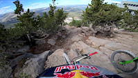
Upper Pro-GRT course from 2018.

Access Info

Ride upper skidmarx then follow signs to traverse towards chair 3, then hike a bike to top of chair 3 (facelift express)

Bike Park

Recent Activity on Trail

Past Week
  • 0 rides
  •  
6 Months
  • 1 rides
  • 34 miles avg distance
All
  • 6 rides
  • Last: May 24, 2026
c1c2c3c4
January
February
March
April
May
June
July
August
September
October
November
December
update trails status or condition

Velociraptor Upper Trail Reports

statusdatedescription
Aug 10, 2024 @ 11:00pm
Aug 10, 2024
Jul 26, 2022 @ 11:09am
Jul 26, 2022
Open for 2022
Oct 21, 2020 @ 12:35pm
Oct 21, 2020
Bike park closed for season, see you in 2021!
Aug 5, 2020 @ 1:01pm
Aug 5, 2020
Dec 17, 2019 @ 8:12pm
Dec 17, 2019
Bike Park closed for the season, see you in 2020 :)
more »
Status:
on Aug 10, 2024
Avg: 3.99 (2 votes)
Your vote: 0

view (105)
close
3D
Trail Conditions
  • Unknown
  • Snow Groomed
  • Snow Packed
  • Snow Covered
  • Snow Cover Partial
  • Freeze/thaw Cycle
  • Icy
  • Prevalent Mud
  • Wet
  • Variable
  • Ideal
  • Dry
  • Very Dry
Trail Flow (Ridden Direction)
Trailforks scans users ridelogs to determine the most popular direction each trail is ridden. A good flowing trail network will have most trails flowing in a single direction according to their intension.
The colour categories are based on what percentage of riders are riding a trail in its intended direction.
  • > 96%
  • > 90%
  • > 80%
  • > 70%
  • > 50%
  • < 50%
  • bi-directional trail
  • no data
Trail Last Ridden
Trailforks scans ridelogs to determine the last time a trail was ridden.
  • < 2 days
  • < 1 week
  • < 2 weeks
  • < 1 month
  • < 6 months
  • > 6 months
Trail Ridden Direction
The intended direction a trail should be ridden.
  • Downhill Only
  • Downhill Primary
  • Both Directions
  • Uphill Primary
  • Uphill Only
  • One Direction
Contribute Details
Colors indicate trail is missing specified detail.
  • Description
  • Photos
  • Description & Photos
  • Videos
Trail Popularity ?
Trailforks scans ridelogs to determine which trails are ridden the most in the last 9 months. Trails are compared with nearby trails in the same city region with a possible 25 colour shades. Think of this as a heatmap, more rides = more kinetic energy = warmer colors.
  • most popular
  • popular
  • less popular
  • not popular
ATV/ORV/OHV Filter
Max Vehicle Width
inches
US Cell Coverage
Legend
cell carrier legend

Radar Time
Activity Recordings
Trailforks uses anonymized public activity data. ?
Activity Recordings
Trailforks uses anonymized public activity data. ?
Personal Heatmap
Activity Types
all / none
Options
2
Date range month
Winter Trails
Warning A routing network for winter maps does not exist. Selecting trails using the winter trails layer has been disabled.
Missing Trails
Most Popular
Least Popular
Trails are colored based on popularity. The more popular a trail is, the more red. Less popular trails trend towards green.
Jump Magnitude Heatmap
Heatmap of where riders jump on trails. Zoom in to see individual jumps, click circles to view jump details.
BC Backroad Status

Service Road Atlas is a free to use, community-driven service for viewing and creating reports on the numerous back-country service roads around B.C. and Alberta.

map legend
Slope Aspect
Direction the slope faces
Flat N NE E SE S SW W NW
Trails Deemphasized
Trails are shown in grey.
disable
Only show trails with no bike usage.
Enable
Suggested Layers
Based on selected activity type

    Save the current map location and zoom level as your default home location whenever this page is loaded.

    Save
        Directions to velociraptor-upper trailhead (37.633800, -119.032640)

        Photos

        4 more »
        253 |
        May 11, 2021 @ 12:41pm
        May 11, 2021
        621 |
        Aug 25, 2020 @ 1:12pm
        Aug 25, 2020
        366 |
        Aug 25, 2020 @ 1:13pm
        Aug 25, 2020
        246 |
        Aug 27, 2019 @ 6:49pm
        Aug 27, 2019

        Videos

        3 more »
        Velociraptor First Time Blind Run at Mammoth...
        3:51 | 285 | Jul 11, 2023 , Mammoth Lakes
        Average rider drops Velociraptor @ Mammoth...
        5:07 | 2811 | Sep 10, 2019 , Mammoth Lakes
        Velociraptor
        4:21 | 15201 | Aug 20, 2019 , Mammoth Lakes

        Articles

        Video: Aaron Gwin POV Preview of Mammoth's New DH Trail 'Velociraptor'
        Sep 13, 2019 from pinkbike.com
        The purist's DH trail is now open to the public.

        Trail Products

        1 Review & Comments


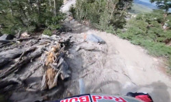
        We hope you've been enjoying Trailforks!

        Create a FREE account to view trail comments and much more.

        • By VRvento & contributors
        • #213351 - 2,803 views

        Frequently Asked Questions About Velociraptor Upper

        Where is Velociraptor Upper located?
        Velociraptor Upper is located in Mammoth Mountain Bike Park, Mammoth Lakes, California, United States. It is part of the Mammoth Mountain Bike Park trail network. The trailhead is located at coordinates 37.6338, -119.03264.
        How hard is Velociraptor Upper?
        Velociraptor Upper is rated as Proline difficulty. The average grade is 20.5%.
        What is the elevation gain for Velociraptor Upper?
        Velociraptor Upper has 26 ft of elevation gain. The trail has 723 ft of elevation descent. The elevation ranges from 9,760 ft to 10,481 ft.
        Is Velociraptor Upper a point to point trail?
        Yes, Velociraptor Upper is a point to point trail. The direction is Downhill Only. The trail type is singletrack.

        Hit the Trail

        Open in App

        Get this trail on your phone instantly.
        open trail in app

        Download Trail

        Save to wishlist, Garmin & download.
        save the trail

        Find Related Routes

        Find routes and users activities that include this trail.
        find routes for this trail

        You must enter a description before submitting.