more stats
1.4 miles
Distance
33 ft
Climb
-1,535 ft
Descent
00:09:18
Avg time
-1,503 ft
Altitude change
2,316 ft
Altitude min
3,819 ft
Altitude max
3,819 ft
Altitude start
2,316 ft
Altitude end
-20.4%
Grade
-112.2%
Grade max
13.9%
Grade min
623 ft
Distance climb
1 mile
Distance down
197 ft
Distance flat
00:09:18
Avg time

Vertigo Details

  • Activities
    • Mountain Bike
  • Riding Area
  • Ref Number
    708T
  • Difficulty Rating
  • Voted Difficulty
    Double Black Diamond (1 vote)
  • Local Popularity
    15 in Mountain Biking
  • Global Ranking
    #124813 in Mountain Biking
  • Trail Type
    Singletrack
  • Bike Type
    DH, AM
  • Direction
    Downhill Only
    Popular Direction Shown
  • Dogs Allowed
    Yes
  • eBike Allowed
  • TTFs on Trail
    Berm, Jump, Gap Jump

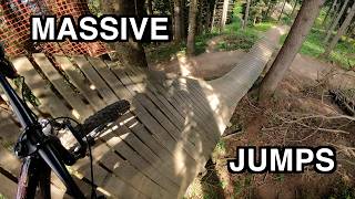
Die schwarz (schwierig) klassierte Freeridestrecke führt von der Mittelstation Känzeli bis zur Talstation in Chur. Technisch anspruchsvoll und mit einigen Sprüngen kommen fortgeschrittene Freerider hier auf ihre Kosten. Für den Bergbahntransport mit Bike sorgen die Bergbahnen Chur. Errichtet und unterhalten wird die Strecke vom Verein
Alpenbikepark Chur, welcher 4 weitere Freeride-Strecken unterhält am Churer Hausberg Brambrüesch.


The black (difficult) classed freeride route leads from the middle station Känzeli to the valley station in Chur. Technically demanding and with a few jumps advanced freeriders get their money's worth here. For the cable car transport with bike provide the mountain railways Chur. The route is being built and maintained by the association Alpenbikepark Chur, which maintains 4 further freeride routes at the Churer Hausberg Brambrüesch.

Bike Park

Local Trail Association

Recent Activity on Trail

Past Week
  • 0 rides
  •  
6 Months
  • 0 rides
  •  
All
  • 27 rides
  • Last: Dec 22, 2025
c1c2c3c4
January
February
March
April
May
June
July
August
September
October
November
December
Status:
on Oct 17, 2025
Variable
Avg: 3.89 (5 votes)
Your vote: 0

view (307)
close
3D
Trail Conditions
  • Unknown
  • Snow Groomed
  • Snow Packed
  • Snow Covered
  • Snow Cover Partial
  • Freeze/thaw Cycle
  • Icy
  • Prevalent Mud
  • Wet
  • Variable
  • Ideal
  • Dry
  • Very Dry
Trail Flow (Ridden Direction)
Trailforks scans users ridelogs to determine the most popular direction each trail is ridden. A good flowing trail network will have most trails flowing in a single direction according to their intension.
The colour categories are based on what percentage of riders are riding a trail in its intended direction.
  • > 96%
  • > 90%
  • > 80%
  • > 70%
  • > 50%
  • < 50%
  • bi-directional trail
  • no data
Trail Last Ridden
Trailforks scans ridelogs to determine the last time a trail was ridden.
  • < 2 days
  • < 1 week
  • < 2 weeks
  • < 1 month
  • < 6 months
  • > 6 months
Trail Ridden Direction
The intended direction a trail should be ridden.
  • Downhill Only
  • Downhill Primary
  • Both Directions
  • Uphill Primary
  • Uphill Only
  • One Direction
Contribute Details
Colors indicate trail is missing specified detail.
  • Description
  • Photos
  • Description & Photos
  • Videos
Trail Popularity ?
Trailforks scans ridelogs to determine which trails are ridden the most in the last 9 months. Trails are compared with nearby trails in the same city region with a possible 25 colour shades. Think of this as a heatmap, more rides = more kinetic energy = warmer colors.
  • most popular
  • popular
  • less popular
  • not popular
ATV/ORV/OHV Filter
Max Vehicle Width
inches
US Cell Coverage
Legend
cell carrier legend

Radar Time
Activity Recordings
Trailforks uses anonymized public activity data. ?
Activity Recordings
Trailforks uses anonymized public activity data. ?
Personal Heatmap
Activity Types
all / none
Options
2
Date range month
Winter Trails
Warning A routing network for winter maps does not exist. Selecting trails using the winter trails layer has been disabled.
Missing Trails
Most Popular
Least Popular
Trails are colored based on popularity. The more popular a trail is, the more red. Less popular trails trend towards green.
Jump Magnitude Heatmap
Heatmap of where riders jump on trails. Zoom in to see individual jumps, click circles to view jump details.
BC Backroad Status

Service Road Atlas is a free to use, community-driven service for viewing and creating reports on the numerous back-country service roads around B.C. and Alberta.

map legend
Slope Aspect
Direction the slope faces
Flat N NE E SE S SW W NW
Trails Deemphasized
Trails are shown in grey.
disable
Only show trails with no bike usage.
Enable
Suggested Layers
Based on selected activity type

    Save the current map location and zoom level as your default home location whenever this page is loaded.

    Save
        Directions to vertigo-129276 trailhead (46.839420, 9.524910)

        Photos

        2 more »
        200 |
        Nov 5, 2021 @ 11:03am
        Nov 5, 2021
        251 |
        Apr 2, 2021 @ 2:38pm
        Apr 2, 2021

        Videos

        1 more »
        Riding All Lines at Alpenbikepark Chur
        24:25 | 30 | Dec 8, 2025 , Chur

        Trail Lists

        Trail Products

        2 Reviews & Comments


        We hope you've been enjoying Trailforks!

        Create a FREE account to view trail comments and much more.

        • By joeldangeloneTF Pro & contributors
        • #129276 - 2,018 views

        Frequently Asked Questions About Vertigo

        Where is Vertigo located?
        Vertigo is located in Alpen Bikepark, Chur, Switzerland. It is part of the Alpen Bikepark trail network. The trailhead is located at coordinates 46.83942, 9.52491.
        How hard is Vertigo?
        Vertigo is rated as Black difficulty. The average grade is 20.4%.
        What is the elevation gain for Vertigo?
        Vertigo has 10 m of elevation gain. The trail has 468 m of elevation descent. The elevation ranges from 706 m to 1,164 m.
        Is Vertigo a point to point trail?
        Yes, Vertigo is a point to point trail. The direction is Downhill Only. The trail type is singletrack.

        Hit the Trail

        Open in App

        Get this trail on your phone instantly.
        open trail in app

        Download Trail

        Save to wishlist, Garmin & download.
        save the trail

        Find Related Routes

        Find routes and users activities that include this trail.
        find routes for this trail

        You must enter a description before submitting.