This trail is permanently closed/decommissioned
more stats
3,074 ft
Distance
16 ft
Climb
-219 ft
Descent
00:07:34
Avg time
-204 ft
Altitude change
100 ft
Altitude min
308 ft
Altitude max
308 ft
Altitude start
105 ft
Altitude end
-6.6%
Grade
-24.5%
Grade max
8.5%
Grade min
344 ft
Distance climb
2,428 ft
Distance down
302 ft
Distance flat
00:07:34
Avg time

V-Fib Details

  • Activities
    • Mountain Bike
    • Winter Fat Bike
    • Hike
    • Trail Running
  • Riding Area
    MVP
    Fredericton, New Brunswick
  • Difficulty Rating
  • Local Popularity
    65 in Mountain Biking [+]
    • 5 in Trail Running
    • 5 in Hiking
  • Trail Type
    Singletrack
  • Bike Type
    DH, AM, XC, Fat
  • Direction
    Downhill Primary
    Popular Direction Shown
  • Climb Difficulty
    Black Diamond
  • Physical Rating
    Moderate
  • Season
    Avoid riding before may long weekend each year.
  • Dogs Allowed
    Yes
  • eBike Allowed
  • TTFs on Trail
    Berm, Jump
  • Year Opened
    2017

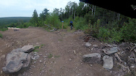
A sweet downhill that will take you through the largest vertical drop at MVP. A clearcut section takes you down to some beautiful lines down in the woods. Pop out into the bottom of the clearcut and enjoy some sweet contoured benching that takes you out onto Fern Gully Rd. This trail can also be attempted as a climb (aka V-Fib).

Local Trail Association

Recent Activity on Trail

Past Week
  • 0 rides
  •  
6 Months
  • 1 rides
  • 7 miles avg distance
All
  • 242 rides
  • Last: Jun 10, 2026
c1c2c3c4
January
February
March
April
May
June
July
August
September
October
November
December
update trails status or condition

V-Fib Trail Reports

statusdatedescription
Jul 9, 2024 @ 8:16am
Jul 9, 2024
Oct 15, 2023 @ 4:15am
Oct 15, 2023
Aug 7, 2023 @ 8:53am
Aug 7, 2023
May 15, 2023 @ 8:00am
May 15, 2023
Top is super loose, improves as decent goes down, Culvert pipe partially washed out near bottom, but not a major issue.
Dec 19, 2022 @ 4:30pm
Dec 19, 2022
reporter
more »
Status:
on Jul 9, 2024
Avg: 4.32 (3 votes)
Your vote: 0

view (2,749)
close
3D
Trail Conditions
  • Unknown
  • Snow Groomed
  • Snow Packed
  • Snow Covered
  • Snow Cover Partial
  • Freeze/thaw Cycle
  • Icy
  • Prevalent Mud
  • Wet
  • Variable
  • Ideal
  • Dry
  • Very Dry
Trail Flow (Ridden Direction)
Trailforks scans users ridelogs to determine the most popular direction each trail is ridden. A good flowing trail network will have most trails flowing in a single direction according to their intension.
The colour categories are based on what percentage of riders are riding a trail in its intended direction.
  • > 96%
  • > 90%
  • > 80%
  • > 70%
  • > 50%
  • < 50%
  • bi-directional trail
  • no data
Trail Last Ridden
Trailforks scans ridelogs to determine the last time a trail was ridden.
  • < 2 days
  • < 1 week
  • < 2 weeks
  • < 1 month
  • < 6 months
  • > 6 months
Trail Ridden Direction
The intended direction a trail should be ridden.
  • Downhill Only
  • Downhill Primary
  • Both Directions
  • Uphill Primary
  • Uphill Only
  • One Direction
Contribute Details
Colors indicate trail is missing specified detail.
  • Description
  • Photos
  • Description & Photos
  • Videos
Trail Popularity ?
Trailforks scans ridelogs to determine which trails are ridden the most in the last 9 months. Trails are compared with nearby trails in the same city region with a possible 25 colour shades. Think of this as a heatmap, more rides = more kinetic energy = warmer colors.
  • most popular
  • popular
  • less popular
  • not popular
ATV/ORV/OHV Filter
Max Vehicle Width
inches
US Cell Coverage
Legend
cell carrier legend

Radar Time
Activity Recordings
Trailforks uses anonymized public activity data. ?
Activity Recordings
Trailforks uses anonymized public activity data. ?
Personal Heatmap
Activity Types
all / none
Options
2
Date range month
Winter Trails
Warning A routing network for winter maps does not exist. Selecting trails using the winter trails layer has been disabled.
Missing Trails
Most Popular
Least Popular
Trails are colored based on popularity. The more popular a trail is, the more red. Less popular trails trend towards green.
Jump Magnitude Heatmap
Heatmap of where riders jump on trails. Zoom in to see individual jumps, click circles to view jump details.
BC Backroad Status

Service Road Atlas is a free to use, community-driven service for viewing and creating reports on the numerous back-country service roads around B.C. and Alberta.

map legend
Slope Aspect
Direction the slope faces
Flat N NE E SE S SW W NW
Trails Deemphasized
Trails are shown in grey.
disable
Only show trails with no bike usage.
Enable
Suggested Layers
Based on selected activity type

    Save the current map location and zoom level as your default home location whenever this page is loaded.

    Save
        Directions to vfib-91285 trailhead (45.984820, -66.556950)

        Photos

        2 more »
        135 |
        May 30, 2020 @ 7:00pm
        May 30, 2020
        140 |
        May 30, 2020 @ 6:59pm
        May 30, 2020

        Videos

        2 more »
        V-Fib // MVP Park
        3:13 | 514 | Aug 4, 2021 , Fredericton
        MVP V-FIB
        3:15 | 528 | Aug 26, 2019 , Fredericton

        Trail Lists

        Routes with this trail

        17 miles 1,890 ft 61
        Routing of every trail at mvp except a small portion of with the least amount of doubling up on trails
        5.0 7 miles 1,142 ft 16 Loop
        An option to sample a little bit of everything at MVP. Warm up on the mini-ex trails, and head over the...
        6 miles 725 ft 10 Loop
        MVP Social Ride route. Samples a little bit of each trail type and moves over to .

        2 Reviews & Comments


        We hope you've been enjoying Trailforks!

        Create a FREE account to view trail comments and much more.

        • By alexisberube RVC & contributors
        • #91285 - 2,075 views

        Frequently Asked Questions About V-Fib

        Where is V-Fib located?
        V-Fib is located in MVP, Fredericton, New Brunswick, Canada. It is part of the MVP trail network. The trailhead is located at coordinates 45.98482, -66.55695.
        How hard is V-Fib?
        V-Fib is rated as Blue difficulty. The physical rating is Moderate. The average grade is 6.6%. The climb difficulty is rated Black Diamond.
        What is the elevation gain for V-Fib?
        V-Fib has 5 m of elevation gain. The trail has 67 m of elevation descent. The elevation ranges from 31 m to 94 m.
        Is V-Fib a point to point trail?
        V-Fib is not a point to point trail. The direction is Downhill Primary. The trail type is singletrack.

        Hit the Trail

        Open in App

        Get this trail on your phone instantly.
        open trail in app

        Download Trail

        Save to wishlist, Garmin & download.
        save the trail

        Find Related Routes

        Find routes and users activities that include this trail.
        find routes for this trail

        You must enter a description before submitting.