more stats
4.0 miles
Distance
273 ft
Climb
-272 ft
Descent
00:33:29
Avg time
0 ft
Altitude change
856 ft
Altitude min
930 ft
Altitude max
856 ft
Altitude start
856 ft
Altitude end
-16.9%
Grade max
15.5%
Grade min
1 mile
Distance climb
1 mile
Distance down
1 mile
Distance flat
00:33:29
Avg time

Voodoo Loop Details

  • Activities
    • Mountain Bike
    • Hike
    • Trail Running
  • Riding Area
    Allatoona Creek Park
    Acworth, Georgia
  • Difficulty Rating
  • Voted Difficulty
    Black Diamond (1 vote)
  • Local Popularity
    55 in Mountain Biking [+]
    • 5 in Trail Running
    • 65 in Hiking
  • Global Ranking
    #35551 in Mountain Biking [+]
    • #39456 in Trail Running
    • #36069 in Hiking
  • Trail Type
    Singletrack
  • Climb Difficulty
    Black Diamond
  • Physical Rating
    Hard
  • Dogs Allowed
    Yes
  • TTFs on Trail
    Rock Garden, Skinny
  • Land Owner
    Cobb County Parks

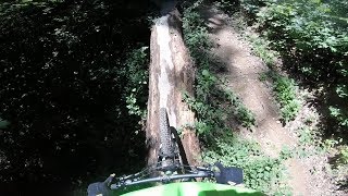
Voodoo is part of Allatoona Creek Park. It has many advanced features like rock and log crossings, a challenging creek crossing, short, steep climbs and some fast downhill areas. Riders should dismount if they are not comfortable with riding one of its many technical features.

You must ride Mumbo Jumbo to get to Voodoo’s trailhead. Voodoo connects into the even more technical Hocus Pocus trail.

The trail direction changes daily so check the trailhead sign. There are several emergency access crossings. When in doubt on which way to go, look for red diamonds mounted on trees to guide you.

Those on foot should travel in the opposite direction of cyclists, and are asked to yield to cyclists using the trails. The trail may close due to wet conditions. Please check mtbatlanta.com for the current trail status.

Note: Bow hunting season closes Voodoo from October 15 through December. It reopens Jan. 1.

Trail Supporters
Local Trail Association

Recent Activity on Trail

Past Week
  • 1 rides
  • 33 miles average
6 Months
  • 20 rides
  • 16 miles avg distance
All
  • 242 rides
  • Last: Jun 16, 2026
c1c2c3c4
January
February
March
April
May
June
July
August
September
October
November
December
update trails status or condition

Voodoo Loop Trail Reports

statusdatedescription
Oct 16, 2025 @ 3:47pm (America/New_York)
Oct 16, 2025
Back open as of January 1.
Sep 10, 2025 @ 11:14am
Sep 10, 2025
shortly after the bridge to mumbo jumbo going counter clockwise
Mar 27, 2025 @ 11:56am
Mar 27, 2025
Jan 1, 2025 @ 11:10am
Jan 1, 2025
Hunting season is over as of Jan. 1 and Voodoo is now open for riding and hiking. Leaf covered in spots. Check daily trail status at mtbatlanta.com
Oct 15, 2024 @ 4:22pm
Oct 15, 2024
Closed for hunting season. Reopens Jan. 1.
more »
Status:
on Oct 16, 2025
Variable
Avg: 4.33 (9 votes)
Your vote: 0

view (1,476)
close
3D
Trail Conditions
  • Unknown
  • Snow Groomed
  • Snow Packed
  • Snow Covered
  • Snow Cover Partial
  • Freeze/thaw Cycle
  • Icy
  • Prevalent Mud
  • Wet
  • Variable
  • Ideal
  • Dry
  • Very Dry
Trail Flow (Ridden Direction)
Trailforks scans users ridelogs to determine the most popular direction each trail is ridden. A good flowing trail network will have most trails flowing in a single direction according to their intension.
The colour categories are based on what percentage of riders are riding a trail in its intended direction.
  • > 96%
  • > 90%
  • > 80%
  • > 70%
  • > 50%
  • < 50%
  • bi-directional trail
  • no data
Trail Last Ridden
Trailforks scans ridelogs to determine the last time a trail was ridden.
  • < 2 days
  • < 1 week
  • < 2 weeks
  • < 1 month
  • < 6 months
  • > 6 months
Trail Ridden Direction
The intended direction a trail should be ridden.
  • Downhill Only
  • Downhill Primary
  • Both Directions
  • Uphill Primary
  • Uphill Only
  • One Direction
Contribute Details
Colors indicate trail is missing specified detail.
  • Description
  • Photos
  • Description & Photos
  • Videos
Trail Popularity ?
Trailforks scans ridelogs to determine which trails are ridden the most in the last 9 months. Trails are compared with nearby trails in the same city region with a possible 25 colour shades. Think of this as a heatmap, more rides = more kinetic energy = warmer colors.
  • most popular
  • popular
  • less popular
  • not popular
ATV/ORV/OHV Filter
Max Vehicle Width
inches
US Cell Coverage
Legend
cell carrier legend

Radar Time
Activity Recordings
Trailforks uses anonymized public activity data. ?
Activity Recordings
Trailforks uses anonymized public activity data. ?
Personal Heatmap
Activity Types
all / none
Options
2
Date range month
Winter Trails
Warning A routing network for winter maps does not exist. Selecting trails using the winter trails layer has been disabled.
Missing Trails
Most Popular
Least Popular
Trails are colored based on popularity. The more popular a trail is, the more red. Less popular trails trend towards green.
Jump Magnitude Heatmap
Heatmap of where riders jump on trails. Zoom in to see individual jumps, click circles to view jump details.
BC Backroad Status

Service Road Atlas is a free to use, community-driven service for viewing and creating reports on the numerous back-country service roads around B.C. and Alberta.

map legend
Slope Aspect
Direction the slope faces
Flat N NE E SE S SW W NW
Trails Deemphasized
Trails are shown in grey.
disable
Only show trails with no bike usage.
Enable
Suggested Layers
Based on selected activity type

    Save the current map location and zoom level as your default home location whenever this page is loaded.

    Save
        Directions to voodoo-loop-56486 trailhead (34.029330, -84.723750)

        Photos

        21 more »
        179 |
        Apr 27, 2025 @ 11:48am
        Apr 27, 2025
        214 |
        Oct 21, 2024 @ 8:32am
        Oct 21, 2024
        120 |
        Sep 23, 2024 @ 5:01pm
        Sep 23, 2024
        140 |
        Feb 24, 2024 @ 9:40am
        Feb 24, 2024

        Videos

        1 more »
        Voodoo - Allatoona Creek - Acworth, GA
        31:29 | 1655 | Jun 5, 2018 , Acworth

        Routes with this trail

        37 miles 1,804 ft 28 Race
        2026 All-Toona race course. Registration available here: For more details, see the full event website at...

        6 Reviews & Comments


        We hope you've been enjoying Trailforks!

        Create a FREE account to view trail comments and much more.

        Frequently Asked Questions About Voodoo Loop

        Where is Voodoo Loop located?
        Voodoo Loop is located in Allatoona Creek Park, Acworth, Georgia, United States. It is part of the Allatoona Creek Park trail network. The trailhead is located at coordinates 34.02933, -84.72375.
        How hard is Voodoo Loop?
        Voodoo Loop is rated as Black Diamond difficulty. The physical rating is Hard. The climb difficulty is rated Black Diamond.
        What is the elevation gain for Voodoo Loop?
        Voodoo Loop has 273 ft of elevation gain. The trail has 272 ft of elevation descent. The elevation ranges from 856 ft to 930 ft.
        How long is Voodoo Loop?
        Voodoo Loop is 4.0 miles long. The trail type is singletrack.

        Hit the Trail

        Open in App

        Get this trail on your phone instantly.
        open trail in app

        Download Trail

        Save to wishlist, Garmin & download.
        save the trail

        Find Related Routes

        Find routes and users activities that include this trail.
        find routes for this trail

        You must enter a description before submitting.