more stats
1,086 ft
Distance
53 ft
Climb
00:03:19
Avg time
52 ft
Altitude change
3,454 ft
Altitude min
3,507 ft
Altitude max
3,454 ft
Altitude start
3,507 ft
Altitude end
4.8%
Grade
-0.6%
Grade max
15.1%
Grade min
968 ft
Distance climb
00:03:19
Avg time

Wagon Wheels Details

  • Activities
    • Mountain Bike
    • E-Bike
    • Gravel Bike
    • Hike
    • Trail Running
  • Riding Area
    White Cliffs Trail System
    Kingman, Arizona
  • Difficulty Rating
  • Voted Difficulty
    Green (1 vote)
  • Local Popularity
    85 in Mountain Biking [+]
    • 85 in E-Biking
    • 100 in Trail Running
    • 100 in Hiking
  • Hiking SAC Scale
    T1 Hiking
  • Trail Type
    Singletrack
  • Bike Type
    AM, XC, Fat, Gravel
  • Direction
    Both Directions
  • Climb Difficulty
    Blue
  • Physical Rating
    Easy
  • Trail Visibility
    Always easy to follow
  • Dogs Allowed
    Yes
  • eBike Allowed
    Yes up to Class 1
  • Land Owner
    City of Kingman Parks

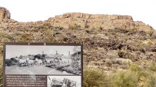
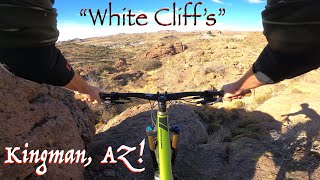
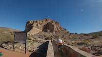
White Cliffs Wagon Wheels Trail is built around a historic wagon road in Downtown Kingman. The rutted sandstone roadway leads to a stacked loop system with many options. This diverse trail uses bench cut contoured singletrack trail encompassing the cliff sides, and slick rock like butte flats overlooking the town.

Local Trail Association
Traditionally Indigenous Territory

Recent Activity on Trail

Past Week
  • 0 rides
  •  
6 Months
  • 13 rides
  • 5 miles avg distance
All
  • 197 rides
  • Last: May 19, 2026
c1c2c3c4
January
February
March
April
May
June
July
August
September
October
November
December
update trails status or condition

Wagon Wheels Trail Reports

Status:
on Feb 5, 2025
Dry
Avg: 4.29 (4 votes)
Your vote: 0

view (1,457)
close
3D
Trail Conditions
  • Unknown
  • Snow Groomed
  • Snow Packed
  • Snow Covered
  • Snow Cover Partial
  • Freeze/thaw Cycle
  • Icy
  • Prevalent Mud
  • Wet
  • Variable
  • Ideal
  • Dry
  • Very Dry
Trail Flow (Ridden Direction)
Trailforks scans users ridelogs to determine the most popular direction each trail is ridden. A good flowing trail network will have most trails flowing in a single direction according to their intension.
The colour categories are based on what percentage of riders are riding a trail in its intended direction.
  • > 96%
  • > 90%
  • > 80%
  • > 70%
  • > 50%
  • < 50%
  • bi-directional trail
  • no data
Trail Last Ridden
Trailforks scans ridelogs to determine the last time a trail was ridden.
  • < 2 days
  • < 1 week
  • < 2 weeks
  • < 1 month
  • < 6 months
  • > 6 months
Trail Ridden Direction
The intended direction a trail should be ridden.
  • Downhill Only
  • Downhill Primary
  • Both Directions
  • Uphill Primary
  • Uphill Only
  • One Direction
Contribute Details
Colors indicate trail is missing specified detail.
  • Description
  • Photos
  • Description & Photos
  • Videos
Trail Popularity ?
Trailforks scans ridelogs to determine which trails are ridden the most in the last 9 months. Trails are compared with nearby trails in the same city region with a possible 25 colour shades. Think of this as a heatmap, more rides = more kinetic energy = warmer colors.
  • most popular
  • popular
  • less popular
  • not popular
ATV/ORV/OHV Filter
Max Vehicle Width
inches
US Cell Coverage
Legend
cell carrier legend

Radar Time
Activity Recordings
Trailforks uses anonymized public activity data. ?
Activity Recordings
Trailforks uses anonymized public activity data. ?
Personal Heatmap
Activity Types
all / none
Options
2
Date range month
Winter Trails
Warning A routing network for winter maps does not exist. Selecting trails using the winter trails layer has been disabled.
Missing Trails
Most Popular
Least Popular
Trails are colored based on popularity. The more popular a trail is, the more red. Less popular trails trend towards green.
Jump Magnitude Heatmap
Heatmap of where riders jump on trails. Zoom in to see individual jumps, click circles to view jump details.
BC Backroad Status

Service Road Atlas is a free to use, community-driven service for viewing and creating reports on the numerous back-country service roads around B.C. and Alberta.

map legend
Slope Aspect
Direction the slope faces
Flat N NE E SE S SW W NW
Trails Deemphasized
Trails are shown in grey.
disable
Only show trails with no bike usage.
Enable
Suggested Layers
Based on selected activity type

    Save the current map location and zoom level as your default home location whenever this page is loaded.

    Save
        Directions to wagon-wheels-409285 trailhead (35.201900, -114.057080)

        Photos

        1 more »
        21 |
        Feb 5, 2025 @ 11:12pm
        Feb 5, 2025
        46 |
        Apr 4, 2024 @ 5:17pm
        Apr 4, 2024
        69 |
        Dec 29, 2022 @ 10:32pm
        Dec 29, 2022

        Videos

        3 more »
        Bird singing at the White Cliffs trailhead...
        0:16 | 53 | Feb 6, 2025 , Kingman
        MTB in Kingman, AZ's 'White Cliff's'...
        11:31 | 70 | Mar 19, 2024 , Kingman
        White Cliffs (Kingman, AZ) - Wagon Wheels
        3:38 | 86 | Nov 27, 2022 , Kingman

        Routes with this trail

        5.0 9 miles 1,009 ft 26
        This is a good course to follow showing all the trails ridden in the best direction. There are only a...

        Reviews / Comments

        No reviews yet, be the first to write a review or ask a question.
        Use trail reports to comment on trail conditions.


        We hope you've been enjoying Trailforks!

        Create a FREE account to view trail comments and much more.

        • By dedmann & contributors
        • #409285 - 1,182 views

        Frequently Asked Questions About Wagon Wheels

        Where is Wagon Wheels located?
        Wagon Wheels is located in White Cliffs Trail System, Kingman, Arizona, United States. It is part of the White Cliffs Trail System trail network. The trailhead is located at coordinates 35.2019, -114.05708.
        How hard is Wagon Wheels?
        Wagon Wheels is rated as Green difficulty. The physical rating is Easy. The average grade is 4.8%. The climb difficulty is rated Blue.
        What is the elevation gain for Wagon Wheels?
        Wagon Wheels has 53 ft of elevation gain. The elevation ranges from 3,454 ft to 3,507 ft.
        Is Wagon Wheels a point to point trail?
        Wagon Wheels is not a point to point trail. The direction is Both Directions. The trail type is singletrack.

        Hit the Trail

        Open in App

        Get this trail on your phone instantly.
        open trail in app

        Download Trail

        Save to wishlist, Garmin & download.
        save the trail

        Find Related Routes

        Find routes and users activities that include this trail.
        find routes for this trail

        You must enter a description before submitting.